Sunday Weather Briefing Video: Severe Weather Potential Over Southern Half of Alabama Today, Potential Freeze Monday and Tuesday Nights
THIRTY YEARS AGO TODAY: Do you remember where you were on this date 30 years ago? If you were anywhere in the eastern third of these United States you were probably under assault by one of the greatest storms of all time. The 1993 March Superstorm brought tremendous cold, snow, wind, tornadoes, and even storm surge to a large part of the country. Here in Alabama, we racked up 13 inches of snow in Birmingham, our greatest snowstorm ever. The city was paralyzed for the better part of four days.
SPRING FORWARD THIS MORNING: We have gone back on to Daylight Saving Time this Sunday morning. If you have to manually set your clocks, it would be a good time to move up one hour. Sorry about that hour of sleep you lost last night…
ON THE WEATHER MAPS: We find a strong upper-level disturbance moving from the Northern Plains to the Midwest. This system will deepen as it moves to the Atlantic Coast over the next couple of days. A surface low is over western Tennessee with a trailing cold front back into eastern Texas. A warm front has lifted through most of Alabama and lies near Chattanooga. This cold front will slowly push through the state today, bringing strong to severe storms along with the rainfall.
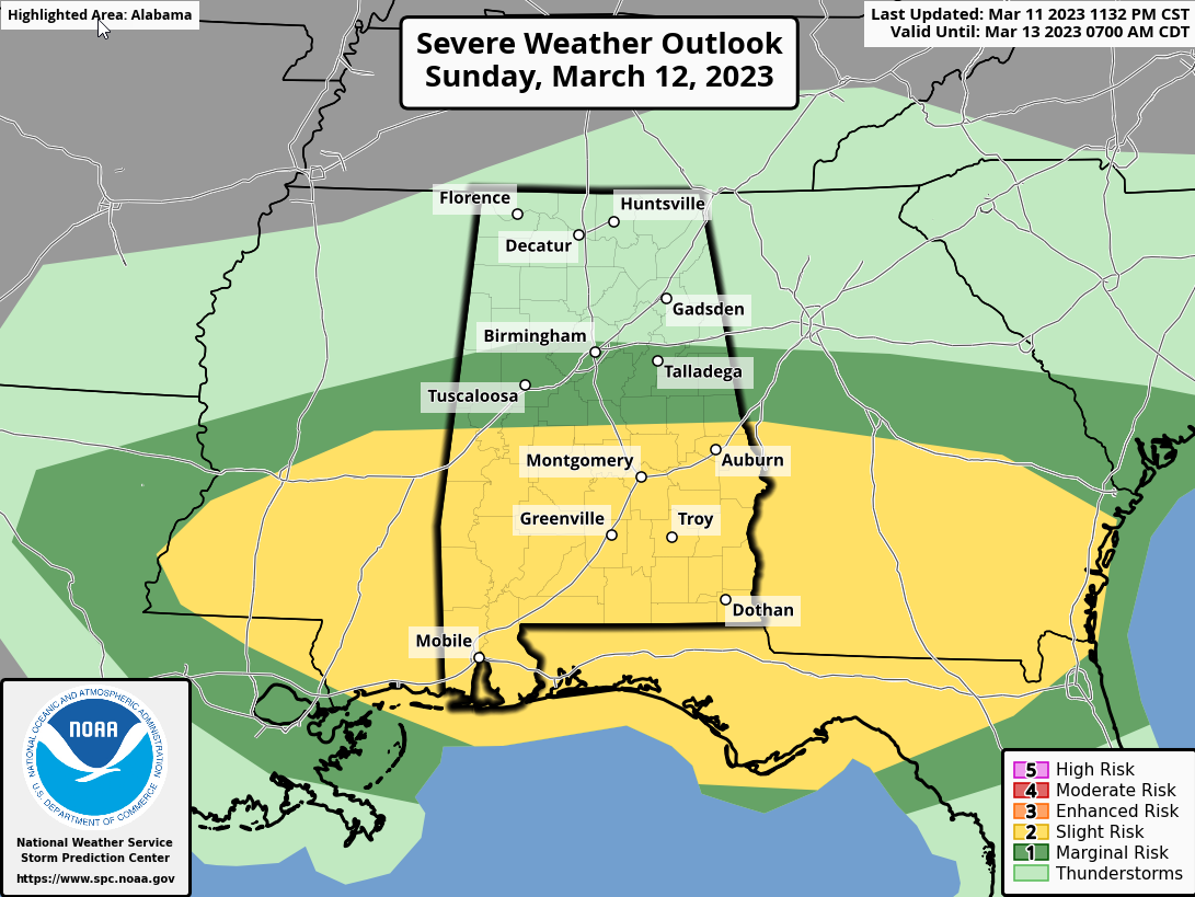
SEVERE POTENTIAL: Scattered showers moved into North and Central Alabama overnight ahead of an area of stronger storms and heavy rain over Mississippi. That heavy rain and thunderstorm activity was pushing southeastward across the area early on this Sunday morning. No severe weather so far, but you can look forward to heavy rain and loud thunder. As the line of storms drops to the south, it will gradually encounter warming and increasing instability, and severe weather is possible generally south of a line from Eutaw to Clanton to Alex City.
By noon, unstable conditions will cover the southern two-thirds of the state with CAPE values in excess of 1,000 joules/kg expected. A second wave of storms will ride along I-20 and point south during the early afternoon, with the potential for severe storms. Damaging winds will be the biggest threat and we can’t rule out an isolated tornado, so stay weather aware. But the storms should intensify as they sag south, with the severe weather threat ramping up during the afternoon and evening for South Central and South Alabama. Damaging winds, hail, and a marginal threat of tornadoes will be in place for South Alabama late Sunday afternoon and evening as the storms sink storm the Florida Panhandle. Places like Jackson, Monroeville, Evergreen, Andalusia, and Ozark will have to be on alert, including down into the Florida Panhandle.
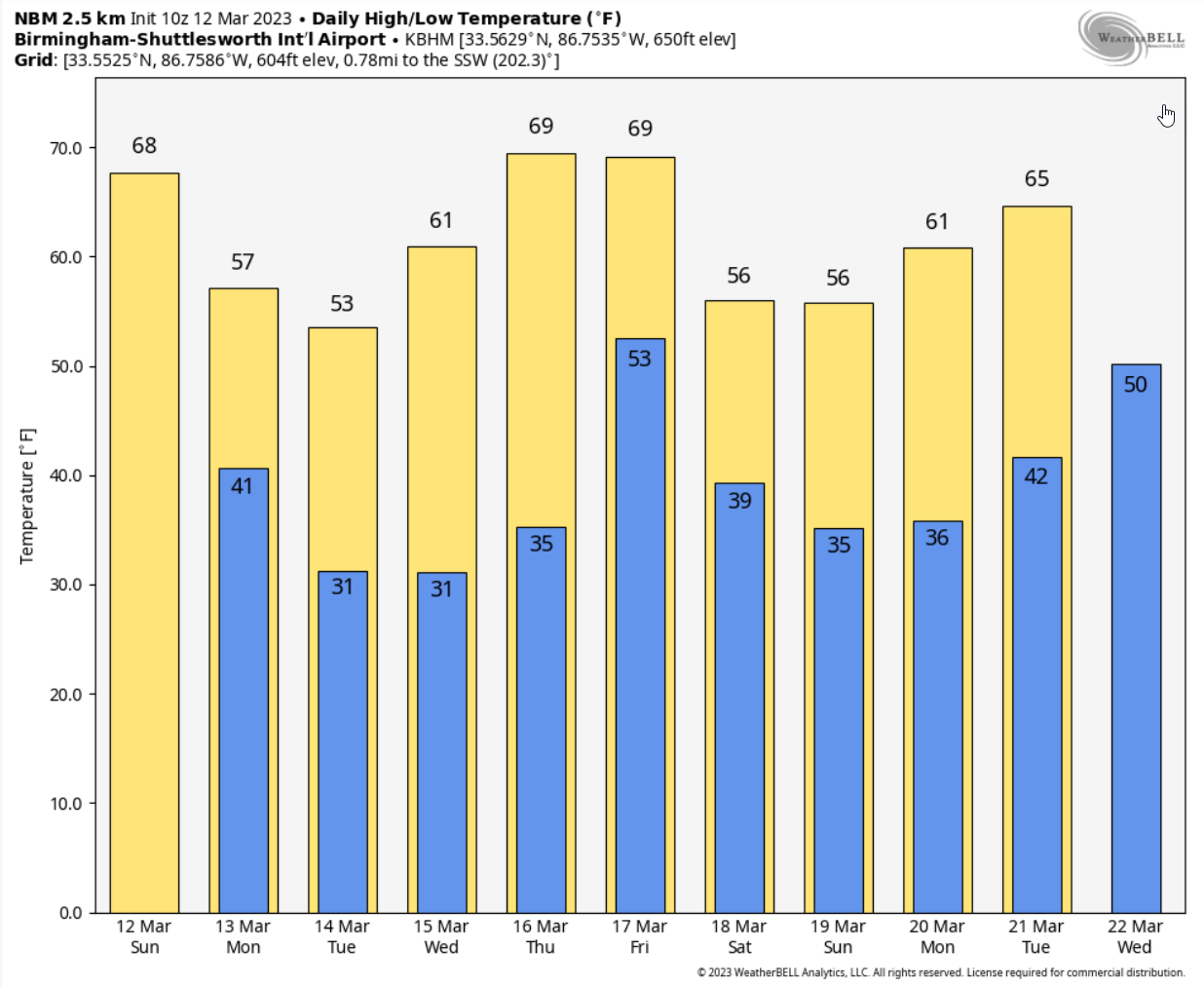
AFTER THE STORMS: Gusty northwesterly winds will usher in cooler air Sunday night with lows falling into the upper 30s to lower 40s. Skies will begin to clear overnight. Those gusty winds will continue into Monday with mostly sunny skies. But high temperatures will climb only into the 50s and lower 60s. Look for an overnight freeze in many locations Monday night and again Tuesday night. Tuesday highs will be in the 50s areawide. We should bounce back into the 60s Wednesday and 70s Thursday for the first round of the NCAA Men’s Basketball Championship at the Legacy Arena. A few showers will show up on Friday with rain likely Friday night, but the precipitation should move out before the second-round games on Saturday. There are some indications from the GFS that the system might move through a little faster, with the heavy rain on Friday during the day, moving out Friday night. We will take that. Temperatures will be in the 70s Friday and 50s on Saturday.
WEEK TWO VOODOO: Rain and storms return pretty quickly on Sunday the 19th. There is a bit of a severe weather look with that system. The GFS hints at some snow mixing in with the rain on the back side of that system. We will be monitoring both possibilities. A second system moves through on Wednesday the 22nd. It looks wet through the remainder of the week and into the weekend. The rest of those Week Two systems don’t seem to have a severe weather or a winter weather look at this time.
BEACHCAST: Rain and thunderstorms will settle into the coastal region later today and tonight but be mostly gone by tomorrow morning. The midweek system will stay south of the beautiful beaches of Alabama and Northwest Florida. More rain and storms will return Friday and depart Friday night, setting the stage for a nice Saturday. But, alas, the rain will return Sunday. ^0s for highs most of the week, except the 70s early and late week. It will be back in the 60s next weekend. Lows will be in the 40s and 50s, except 60s Sunday and Friday mornings. Water temperatures are around 70s. Rip current risk will be high today and tonight, and low to moderate the rest of the way until Wednesday.
Click here to see the Beach Forecast Center page.
NATIONALLY: On November 1st of last year, a record 85.28 percent of the nation was either in drought or abnormally dry. It was an all-time record during the Drought Monitor era. Things have improved substantially in the past five months. Now 54.87% of the nation is either abnormally dry or in drought conditions. That number will probably improve further as California’s conditions improved again with more rain and snow.
DANCING WITH THE STATS: 79F at Galveston Friday afternoon was the warmest for the date. The morning low of 70F also matched the record warm minimum for the date.
GLOBALLY: The longest-lived tropical cyclone in world history, Cyclone Freddy, finally moved inland ostensibly for the last time on the coast of Madagascar last night with top winds of 95 knots or 110 mph. It is its second landfall there after traversing the Mozambique Channel three times and impacting Mozambique as well. The storm originally formed near Indonesia on February 6th and has been around for 34 days since. The system has undergone an amazing six periods of rapid intensification. It should weaken slowly and stall over the next 36 hours before dissipating.
ADVERTISE WITH US: Deliver your message to a highly engaged audience by advertising on the AlabamaWX.com website. We have a lot of big plans for this year. Don’t miss out! We can customize a creative, flexible, and affordable package that will suit your organization’s needs. Contact me, Bill Murray, at (205) 687-0782, and let’s talk.
WEATHERBRAINS: This week, the panel will entertain. Check out the show at www.WeatherBrains.com. You can also subscribe on iTunes. You can watch the show live on our new YouTube channel for the show. You will be able to see the show on the James Spann 24×7 weather channel on cable or directly over the air on the dot 2 feed.
ON THIS DATE IN 1976: A tornado just east of Chicago’s O’Hare Airport missed President Gerald Ford’s motorcade by eight minutes as he was en route to a campaign appearance at the downtown Marriott Hotel. The tornado ripped across an expressway on the President’s route. The F2 tornado was one of eighteen tornadoes that touched down across northern Illinois and Northwest Indiana. Six people died and over 100 were injured. Follow my weather history tweets on Twitter. I am @wxhistorian at Twitter.com.
Category: Alabama's Weather, ALL POSTS, Severe Weather
About the Author (Author Profile)
Bill Murray is the President of The Weather Factory. He is the site's official weather historian and a weekend forecaster. He also anchors the site's severe weather coverage. Bill Murray is the proud holder of National Weather Association Digital Seal #0001 @wxhistorianSubscribe
If you enjoyed this article, subscribe to receive more just like it.


