Dry Today/Tomorrow; Rain Returns Friday
ANOTHER COLD MORNING: Here are some temperatures shortly before sunrise across Alabama…
Gadsden 26
Haleyville 26
Pell City 26
Fort Payne 26
Morris 26
Chelsea 26
Hueytown 27
Jasper 27
Scottsboro 28
Thorsby 28
God Hope 28
Sylacauga 29
Bessemer 29
Birmingham 30
Selma 30
Heflin 30
Anniston 31
Huntsville 31
Tuscaloosa 32
Muscle Shoals 34
Montgomery 35
Dothan 36
Mobile 42
These temperatures will likely drop another degree or two before they begin to rise.
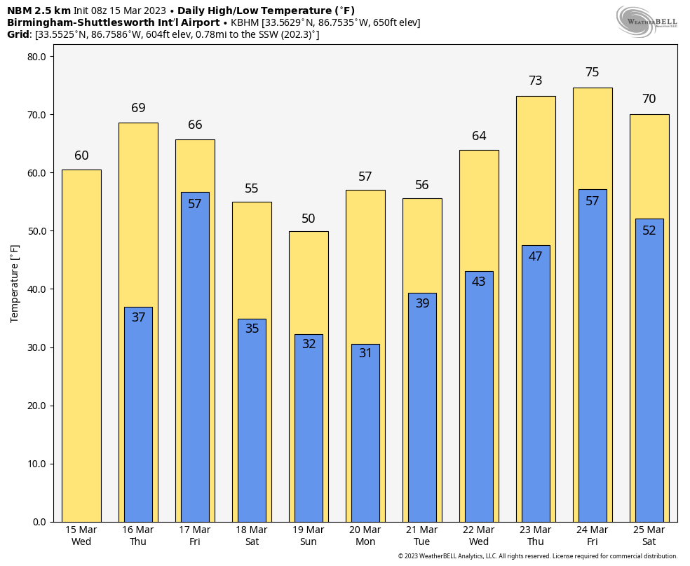
The day ahead will feature sunshine in full supply with highs mostly in the 60s. Tomorrow will be the warmest day of the week with a high in the 68-74 degree range… the air stays dry and the sky will be partly to mostly sunny. Clouds return tomorrow night.
FRIDAY: A cold front will bring rain to the state Friday. SPC has introduced a “slight risk” (level 2/5) of severe thunderstorms for the southwest corner of the state, including places like Mobile, Gulf Shores, Jackson, and Atmore. A “marginal risk” (level 1/5) extends as far north as Greensboro and Auburn.
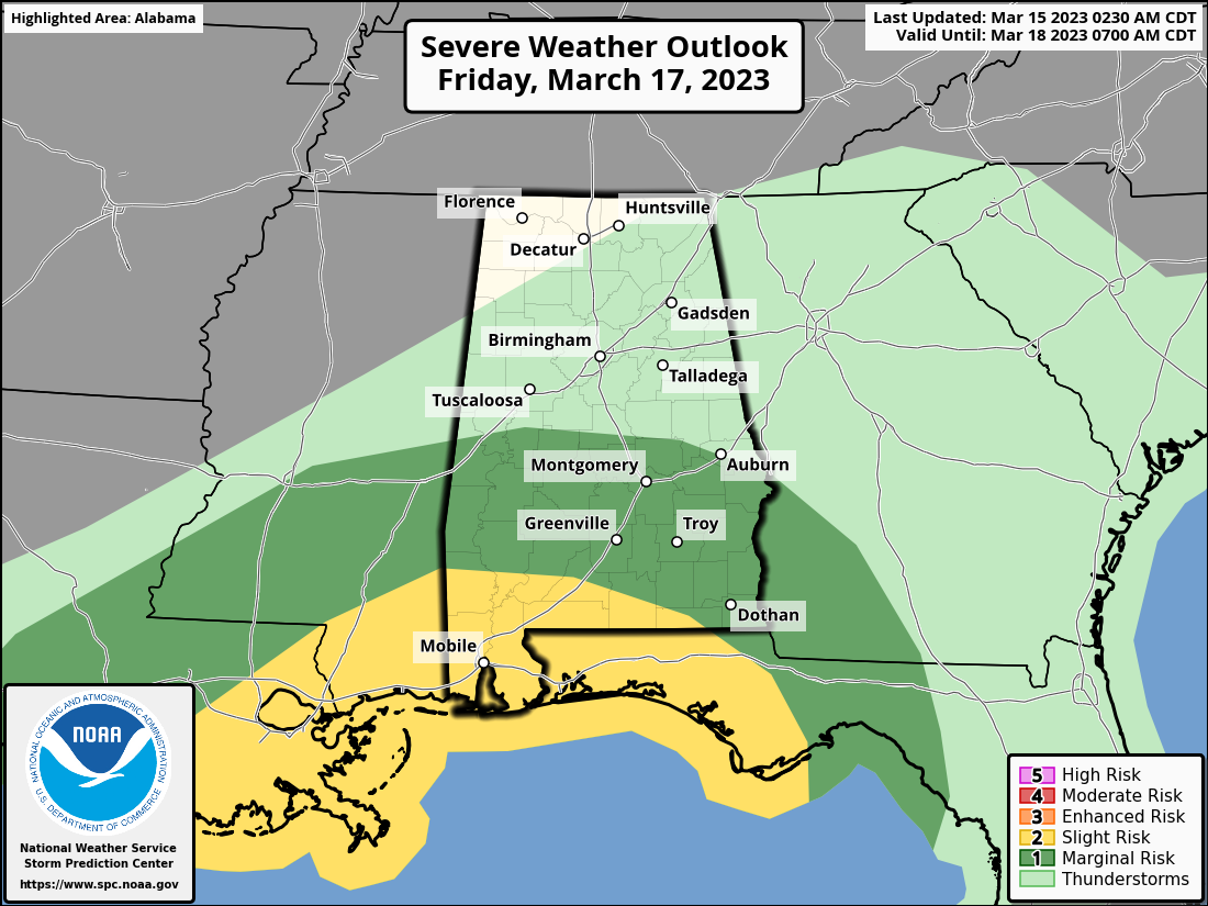
The core risk of heavy storms Friday will be near the Gulf Coast, where some surface based instability will be available. The main threat will come from strong, gusty winds… an isolated tornado can’t ruled out. But, most of the state will simply have a cool, rainy day in a stable airmass. Rain amounts Friday will average around one inch, with isolated heavier totals. Temperatures will hold in the 50s over the northern counties.
THE ALABAMA WEEKEND: Another shot of cold air rolls into the Deep South over the weekend. Temperatures will be in the low to mid 30s early Saturday with a brisk north wind. The sky will become sunny Saturday with a high in the 50s. Clear weather is the story Sunday with another late season freeze during the early morning hours… lows will dip into the 24-34 degree range. The high Sunday will be in the 50s again, about 10-15 degrees below average.
NEXT WEEK: Another freeze is likely early Monday with a low in the upper 20s and low 30s. The day will be mostly sunny with a high in the 50s and 60s. Then, a low forms in the northeast Gulf of Mexico, and rain is likely statewide Tuesday. It will be a cold rain with temperatures only in the 40s and 50s. Rain will end Wednesday morning as the low moves northeast. Thursday looks dry at this point, followed by a chance of showers Friday. Temperatures will likely reach the 70s by the end of the week… See the video briefing for maps, graphics, and more details.
ON THIS DATE IN 1938: A tornado hit McPaul, Iowa, while moving from southeast to northwest. Another tornado raced through Batesville, Illinois, at 60 to 65 mph. Another tornado causing F4 damage killed 10 and injured 12 in St. Clair County, Missouri. This tornado was part of an outbreak that produced four different tornadoes and was responsible for 11 deaths and 42 injuries.
ON THIS DATE IN 2008: An F2 tornado moved through southern Cherokee County, north of Piedmont. The damage was consistent with winds near 115 mph; thankfully there were no injuries.
BEACH FORECAST: Click here to see the AlabamaWx Beach Forecast Center page.
Look for the next video briefing here by 3:00 this afternoon… enjoy the day!
Category: Alabama's Weather, ALL POSTS, Weather Xtreme Videos
About the Author (Author Profile)
James Spann is one of the most recognized and trusted television meteorologists in the industry. He holds the AMS CCM designation and television seals from the AMS and NWA. He is a past winner of the Broadcast Meteorologist of the Year from both professional organizations.Subscribe
If you enjoyed this article, subscribe to receive more just like it.


