Midday Nowcast: Sunny South, Cloudy North
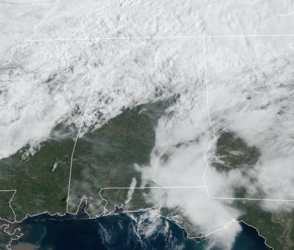
The morning showers across North Alabama continue to fade away and push north into Tennessee. This afternoon we are seeing a mix of sun and clouds across North Alabama, while more sun is shining across Central and South Alabama. It is warmer today with highs surging into the low and mid 70s across the area this afternoon.
THURSDAY/FRIDAY: The warming trend continues tomorrow under a mostly sunny sky; highs tomorrow will be in the low to mid 80s. The day Friday will also be warm and dry with a mix of sun and clouds with more 80s as s strong southerly breeze kicks in ahead of a cold front that will bring rain and storms to Alabama Friday night.
FRIDAY NIGHT STORMS: The cold front will push into Alabama late Friday night and will bring an organized band of thunderstorms into the state. As we expected, the SPC has expanded the severe weather risk into much of Alabama for late Friday night and into Saturday morning. For now, a “slight risk” (level 2/5) of severe storms includes areas west of a line from Fort Payne to Verbena to Camden to Jackson. A “marginal risk” extends as far east and south as Opelika and Geneva.
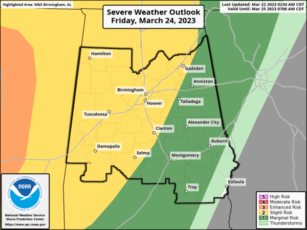
The is a very dynamic system with strong upper-level and surface support, but the main question involves how much instability will be available for the storms as they move through the state. However, strong dynamics can overcome lack of instability sometimes and we are going to be watching the storms carefully as they move into and through the state. This will likely be a linear event with the main threat coming from strong, potentially damaging straight line winds, but a few tornadoes are very possible.
For now, the line of strong to severe storms will approach far West Alabama as early as 9PM, advancing through the state through the early morning hours Saturday. This will be an overnight event, and everyone will need a reliable way of getting warnings. The storms will be exiting the state by sunrise Saturday morning, with improving weather through the day. Most of Saturday will be dry with a mix of sun and clouds and highs in the upper 70s.
SUNDAY, INTO NEXT WEEK: Clouds return quickly Sunday, and some rain looks to move back into the state Sunday afternoon as a warm front begins to lift north through the state. Highs will be in the 70s and 80s on Sunday. Rain and storms remain in the forecast Sunday night, Monday and Tuesday as the air will be warm and unstable, allowing for the chance of some strong storms as well. Highs will remain in the upper 70s through to start the week. The second half of the week looks drier with highs in the 60s and 70s.
BEACH FORECAST CENTER: Get the latest weather and rip current forecasts for the beaches from Fort Morgan to Panama City on our Beach Forecast Center page. There, you can select the forecast of the region that you are interested in visiting.
WORLD TEMPERATURE EXTREMES: Over the last 24 hours, the highest observation outside the U.S. was 107.6F at Matam, Senegal. The lowest observation was -83.4F at Dome A, Antarctica.
CONTIGUOUS TEMPERATURE EXTREMES: Over the last 24 hours, the highest observation was 91F at Falcon Lake and Rio Grande Village, TX. The lowest observation was -12F at Seagull Lake, MN.
Category: Alabama's Weather, ALL POSTS
About the Author (Author Profile)
Macon, Georgia Television Chief Meteorologist, Birmingham native, and long time Contributor on AlabamaWX. Stormchaser. I did not choose Weather, it chose Me. College Football Fanatic. @Ryan_StinnetSubscribe
If you enjoyed this article, subscribe to receive more just like it.


