Midday Nowcast: Marvelous March Day; Storms Tomorrow Night
Ample sunshine and warm temperatures are making for a marvelous March day across Alabama. Highs this afternoon are climbing into the low and mid 80s for much of North/Central Alabama, and with little to no humidity, it if feeling oh so nice. Tonight will be mild with increasing clouds; lows near 60°. Little change tomorrow as another warm day is in store, highs again in the 80s, and it will become more breezy as southerly winds increase.
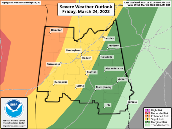
FRIDAY NIGHT STORMS: During the day tomorrow, a significant severe weather outbreak is expected across the ARKLAMISS, where some strong tornadoes are possible, and the SPC has that region outlined in a “moderate risk” (level 4/5) of severe storms. Thankfully, we are not expecting that in Alabama, but as those storms push east into Alabama, we are going to have to deal with the risk of some severe storms in Alabama.
WHAT WE KNOW: The associated front will push into Alabama late tomorrow night bringing strong to severe thunderstorms into the state. The SPC has expanded the “enhanced risk” (level 3/5) of severe thunderstorms into Northwest Alabama, including places like Florence, Russellville, Hamilton, Winfield, Fayette, Vernon, and Gordon. A “slight risk” (level 2/5) extends as far east as Weiss Lake, Sylacauga, and Jackson. A “marginal risk” (level 1/5) covers the rest of East and South Alabama.
The is a very dynamic system with strong upper-level support, but still, the main question involves how much instability will be available for the storms as they move through the state. Again, strong dynamics can overcome lack of instability sometimes and we are going to be watching the storms carefully as they move into and through the state. The main threat will come from strong, potentially damaging straight line winds, perhaps to 70 mph, but a few tornadoes are likely as well, especially in the “enhanced risk” area across Northwest Alabama…Some hail is possible as well.
With events like this it is very important that you have a way of hearing weather warnings in the middle of the night. The baseline for every home and business is a NOAA Weather Radio. Be sure your phone has WEA (Wireless Emergency Alerts) enabled, and “Do Not Disturb” is not active. Know the safe place in your home, and have helmets for everyone in the family there. If you live in a mobile home, know the location of the nearest shelter (or business that is open 24/7 that can serve as a shelter), and the fastest way of getting there. Have transportation available. It sure isn’t convenient going to a shelter during the pre-dawn hours, but you can’t risk your life staying in a mobile home if you are in a tornado warning polygon.
Rain amounts will average 1/2 to 1 inch… for now flooding issues are not expected.
WEEKEND WEATHER: The rain and storms will be exiting the state early Saturday morning, and the day will feature improving weather. The sky becomes mostly sunny Saturday afternoon and the day will be warm with a high in the low 80s. For Sunday, the front will begin to lift back north, meaning clouds and rain will return to the state through the day. The air will be unstable, and strong storms are possible Sunday afternoon, with the main threats coming from strong winds and hail. The high Sunday will be in the upper 70s.
NEXT WEEK: Rain and storms remain in the forecast Monday and Tuesday as the air will be warm and unstable, allowing for the continued chance of some strong storms as well. Highs will remain in the upper 70s Monday and Tuesday. Dry and cooler air return for Wednesday and Thursday, with highs falling back into the 60s, while lows will be in the upper 30s and lower 40s.
BEACH FORECAST CENTER: Get the latest weather and rip current forecasts for the beaches from Fort Morgan to Panama City on our Beach Forecast Center page. There, you can select the forecast of the region that you are interested in visiting.
WORLD TEMPERATURE EXTREMES: Over the last 24 hours, the highest observation outside the U.S. was 106.7F at Marble Bar, Australia. The lowest observation was -85.7F Vostok, Antarctica.
CONTIGUOUS TEMPERATURE EXTREMES: Over the last 24 hours, the highest observation was 99F at Rio Grande Village, TX. The lowest observation was -13F at White Sulphur Springs, MT.
Category: Alabama's Weather, ALL POSTS


