A Quick Look at Alabama’s Severe Weather Situation
Checking conditions to the west of Alabama this afternoon. We find a weak surface low over western Arkansas and eastern Oklahoma. A deep upper-level trough is pushing eastward out of the Four Corners region of the Southwest.
A warm airmass is currently over Alabama. Dewpoints are in the 60s west of I-65, with 50s to the east. Overnight, the higher dewpoints will overspread the rest of the state as the surface low tracks into Indiana,
A much more unstable airmass exists to the west of Alabama. A narrow wedge of this higher instability will work into western Alabama late this evening. But it will be cut off fairly quickly by a southeastward-moving cold front.
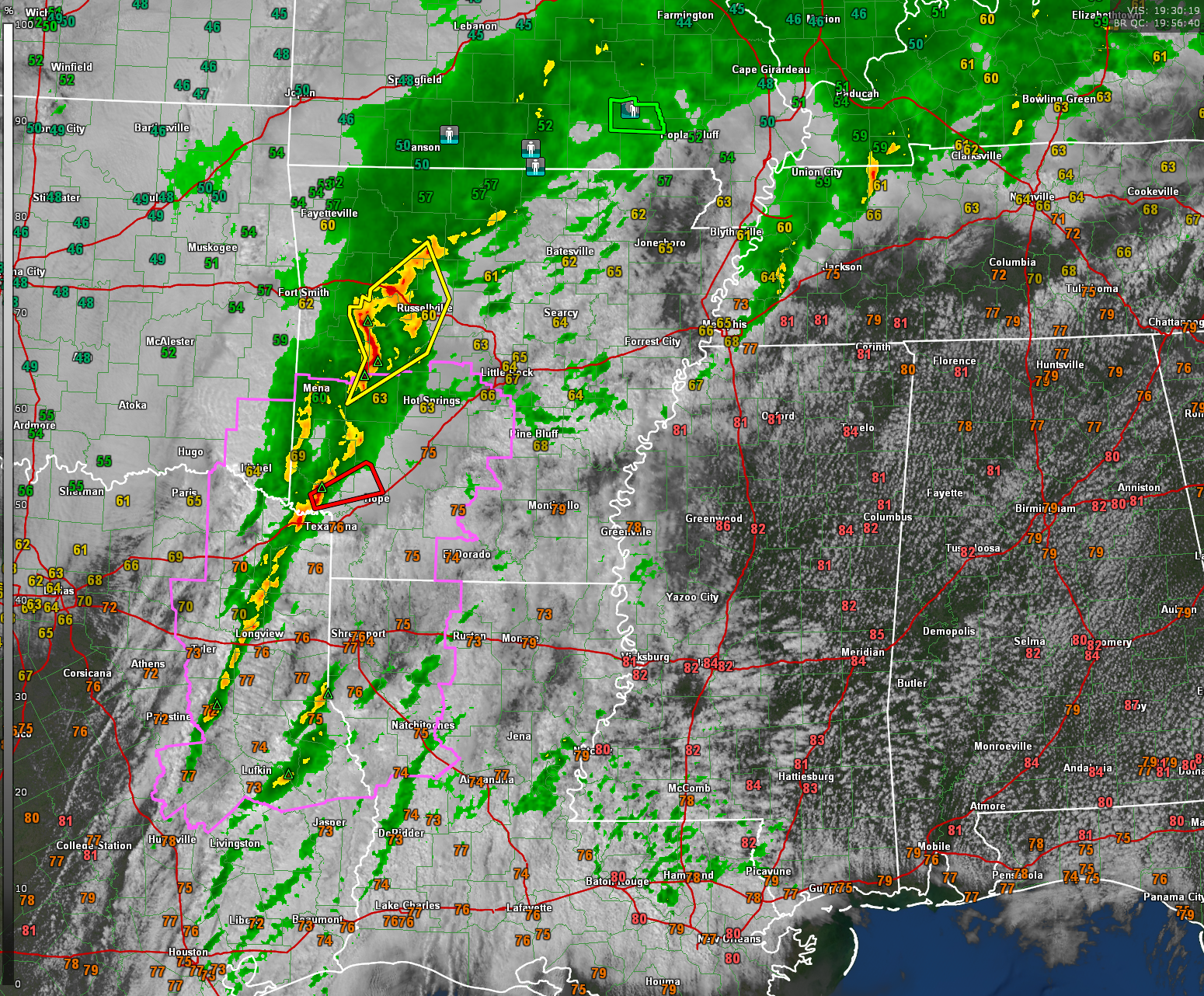
Storms are intensifying now over Northeast Texas and southwestern Arkansas. A large severe thunderstorm warning covers areas in and around Russellville, AR. A tornado warning has just been issued for areas just north of Texarkana.
A tornado watch is in effect for extreme southeastern Oklahoma, Northeast Texas, Northwest Louisiana, and southwestern Arkansas. It goes until 7 p.m. Additional tornado watches will be needed for downstream areas across Araknsas, Tennessee, Louisiana, Mississippi, and Alabama later this afternoon and tonight.
The storms are going to continue to intensify through the rest of the afternoon and the threat of large hail, damaging winds, and tornadoes will increase as well.
As is often the case, the storms will occur during the nighttime hours over Mississippi, much of Tennessee, and Alabama, which makes them even more dangerous. Make sure you have your redundant ways to get alerts during the overnight hours.
The storms should move into the Shreveport area by 5 p.m. and reach the Ruston area along I-20 between 6-8 p.m. The storms will be crossing the Mississippi River in the 7-8 p.m. time frame.
UPDATE
The new SWODY1 is just out from the SPC and it is changed slightly. The SPC has spred the Enhanced Risk deeper into Alabama, bringing it almost as far southeast as I-59.
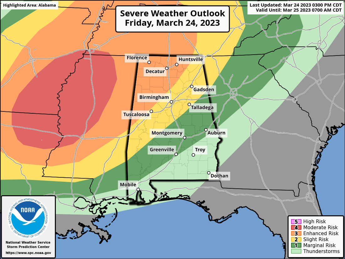
The Moderate Risk is over the ArkLaMiss to our west.
There is a threat of some large, long-track tornadoes over the Mississippi Delta, including places like Monticello AR, Monroe LA, Vicksburg, Yazoo City, Greenville, Greenwood, and Oxford MS. That threat should lessen as the storms congeal into a broken line of storms. Embedded supercells will still be capable of producing tornadoes, but the threat should evolve to more of a wind threat.
The storms will reach the Florence/Muscle Shoals area around 11 pm – midnight. Huntsville and Jasper should see them by 1-2 am. Birmingham, Gadsden, and Tuscaloosa will get them around 230am-330 am. Be aware that timing is approximate and could change.
The rain should move out of the Birmingham/Gadsden areas by 5-6 a.m. and out of Auburn and East Alabama by 7-8 a.m.
James will have the video in just a minute. Check it out. Be prepared. Share information with your neighbors, family, friends, and social networks. The key is awareness. And please check back for frequent updates throughout the night.
Category: Alabama's Weather, ALL POSTS, Severe Weather
About the Author (Author Profile)
Bill Murray is the President of The Weather Factory. He is the site's official weather historian and a weekend forecaster. He also anchors the site's severe weather coverage. Bill Murray is the proud holder of National Weather Association Digital Seal #0001 @wxhistorianSubscribe
If you enjoyed this article, subscribe to receive more just like it.


