Midday Nowcast: Sunny North, Stormy South
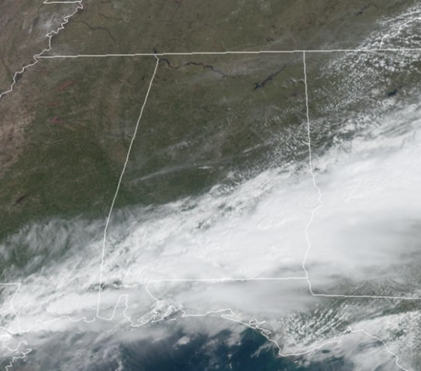
The persistent area of rain continues to shift south today, and the main area for rain and storms is across South Alabama this afternoon and tonight. The SPC maintains a “marginal risk” (level 1/5) of severe thunderstorms this afternoon and evening hours for the southern half of the state, mainly south of a line from Linden to Verbena to Alexander City. With a live 2/5 “slight risk” for the Wiregrass Region of Southeast Alabama.
Heavier storms there could produce strong winds and small hail; we don’t expect any tornadoes due to lack of shear as winds are unidirectional. For North/Central Alabama, the rest of the day will be dry with ample sunshine and high in the 70s.
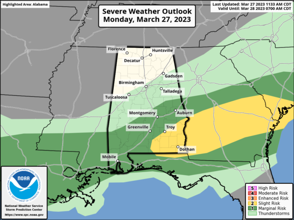
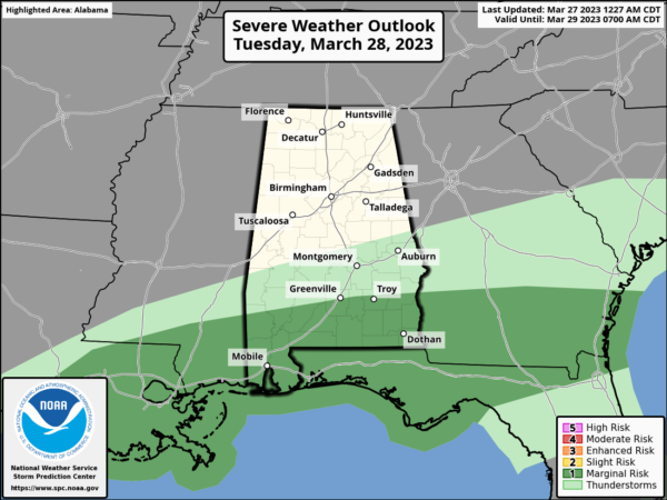
TOMORROW: Most of North/Central Alabama will be dry, showers and storms are possible across the southern half of the state. Once again, SPC has a “marginal risk” (level 1/5) in place there, where strong wind gusts and small hail could occur with the heavier thunderstorms. The risk tomorrow is south of a line from Grove Hill to Greenville to Troy to Eufaula. Highs tomorrow will range from the upper 60s to lower 70s.
WEDNESDAY/THURSDAY: Dry air will cover Alabama, and we get a chance to dry out with sunny pleasant days and clear cool nights. Highs will be in the 60s over North Alabama, with 70s across the southern counties. Colder spots across the northern half of the state could see lows in the mid to upper 30s, but freezing temperatures are not expected this go round.
FRIDAY: Friday will be dry with a mix of sun and clouds with highs surging into the upper 70s and lower 80s. A significant severe weather event is expected during the day Friday north and west of Alabama, and those showers and storms will move in here Friday night. For now, it looks like the main dynamic support will be shunted well north of here thanks to an upper ridge, and the overall severe weather risk looks low. But, we will monitor trends in the coming days as we always have to keep an eye on any system like this in late March and early April.
WEEKEND WEATHER: Showers and storms Saturday morning over North Alabama will shift into the southern counties off the state by Saturday afternoon; the day will be warm with a high in the low 80s in most spots. On Sunday, dry air settles into the state and we are forecasting a mostly sunny sky highs will be in the 60s and 70s.
NEXT WEEK: Moisture begins to return Monday, and the week looks unsettled with potential for multiple rounds for rain and storms. Way too early to know if severe weather will be an issue, but tis the season, as we are in our most active month for severe weather in Alabama.
BEACH FORECAST CENTER: Get the latest weather and rip current forecasts for the beaches from Fort Morgan to Panama City on our Beach Forecast Center page. There, you can select the forecast of the region that you are interested in visiting.
WORLD TEMPERATURE EXTREMES: Over the last 24 hours, the highest observation outside the U.S. was 109.9F at Kolda, Senegal. The lowest observation was -86.8F Concordia, Antarctica.
CONTIGUOUS TEMPERATURE EXTREMES: Over the last 24 hours, the highest observation was 98F at Zapata, TX. The lowest observation was -34F at Peter Sinks, UT.
WEATHER ON THIS DATE IN 1890: An outbreak of tornadoes occurred in the Ohio Valley. One of the tornadoes struck Louisville, KY killing 78 persons and causing four million dollars damage.
Category: Alabama's Weather, ALL POSTS
About the Author (Author Profile)
Macon, Georgia Television Chief Meteorologist, Birmingham native, and long time Contributor on AlabamaWX. Stormchaser. I did not choose Weather, it chose Me. College Football Fanatic. @Ryan_StinnetSubscribe
If you enjoyed this article, subscribe to receive more just like it.


