
Midday Nowcast: Mix of Sun and Clouds; Storms down South
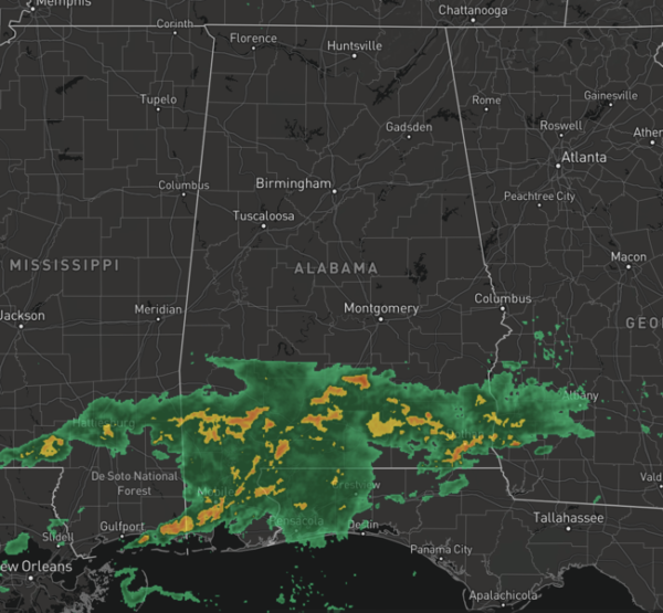
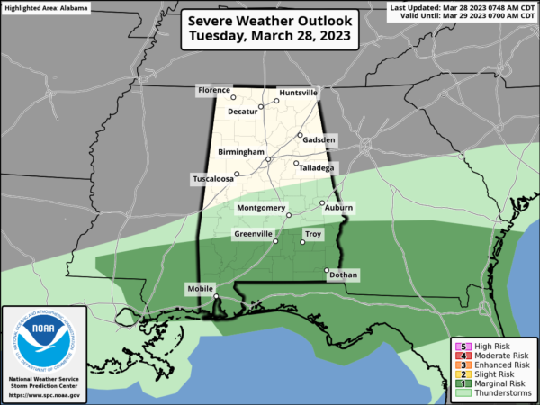
North/Central Alabama is dry and cooler today, but showers and strong storms are ongoing across the southern third of the state and along the Gulf Coast. The SPC has a “marginal risk” (level 1/5) in place there, where strong wind gusts and small hail could occur with the heavier thunderstorms. The risk today is south of a line from Thomasville to Camden to Troy to Eufaula.
Highs this afternoon are in the 60s to lower 70s. Tonight will be breezy and chilly with lows in the upper 30s and lower 40s.
TOMORROW/THURSDAY: Dry air will cover Alabama these two days, and we get a chance to dry out with sunny pleasant days and clear cool nights. Highs will be in the 60s over North Alabama, with 70s across the southern counties. Colder spots across the northern half of the state could see some patchy frost.
FRIDAY: The day will be dry with a mix of sun and clouds with highs surging into the upper 70s and lower 80s. A significant severe weather event will occur during the day Friday north and west of Alabama, and those storms will move into Alabama late Friday night.
STORMS RETURN: A band of rain and thunderstorms will push into the state Friday night into Saturday morning ahead of cold front. The SPC has defined a risk of severe thunderstorms for areas north and west of Birmingham in their “Day 4” outlook, which runs through 7AM Saturday. While the main dynamic support will be passing well to the north of Alabama, the air will be unstable, and severe storms certainly could develop. The SPC is likely to expand the risk into a larger part of Alabama in future outlooks.
WEEKEND WEATHER: The storms Saturday morning over North Alabama will shift into the southern counties off the state by Saturday afternoon. The northern half of the state will see a clearing sky and highs in the 70s. On Sunday, dry air settles into the state and we are forecasting a mostly sunny sky highs will be in the 60s.
NEXT WEEK: Moisture begins to return Monday, and much of the week looks unsettled with the potential for multiple rounds for rain and storms. Way too early to know if severe weather will be an issue, but we will be in our most active month for severe weather in Alabama as April has the the highest amount of tornadoes.
BEACH FORECAST CENTER: Get the latest weather and rip current forecasts for the beaches from Fort Morgan to Panama City on our Beach Forecast Center page. There, you can select the forecast of the region that you are interested in visiting.
WORLD TEMPERATURE EXTREMES: Over the last 24 hours, the highest observation outside the U.S. was 110.3F at Matam, Senegal. The lowest observation was -83.4F Vostok, Antarctica.
CONTIGUOUS TEMPERATURE EXTREMES: Over the last 24 hours, the highest observation was 98F at Zapata, TX. The lowest observation was -34F at Peter Sinks, UT.
Category: Alabama's Weather, ALL POSTS
About the Author (Author Profile)
Macon, Georgia Television Chief Meteorologist, Birmingham native, and long time Contributor on AlabamaWX. Stormchaser. I did not choose Weather, it chose Me. College Football Fanatic. @Ryan_StinnetSubscribe
If you enjoyed this article, subscribe to receive more just like it.


