Midday Nowcast: Sunny Thursday; Storms Late Friday Night
After the morning chill, we are warming up nicely today, and by the end of the day many of us will be in the mid 70s under a sky full of sunshine. Tonight, a few more clouds return and it will be milder with most locations in the 50s. Our Friday will be another a great day of weather; it will be dry, breezy, and warm with highs in the upper 70s to lower 80s.
USA BRIEF: Heavy snow will extend from the mountains of California and the Intermountain West into the Northern Plains. Gusty to strong winds may produce critical fire weather risks over portions of the Central and Southern High Plains. Multi-hazard impacts will stretch from the Lower Mississippi Valley to the Great Lakes by Friday into the weekend.
TO OUR WEST TOMORROW: A significant outbreak of severe weather will occur north and west of Alabama, where the SPC has a “moderate risk” (level 4/5) of severe storms. For Alabama tomorrow night, the SPC maintains an “enhanced risk” (level 3/5) of severe thunderstorms for the northwest corner of Alabama around the Shoals. A “slight risk” (level 2/5) extends as far east as Gadsden, Hoover, and Eutaw. And, there is a “marginal risk” defined as far south as Heflin, Clanton, and Butler.
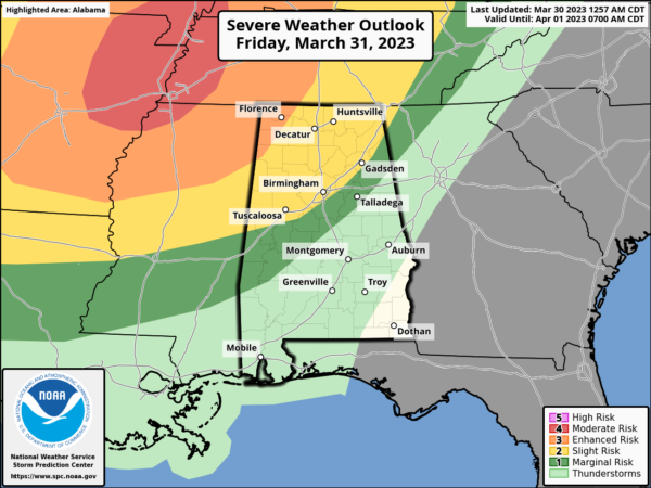
Late tomorrow night, a line of thunderstorms will enter Northwest Alabama around midnight, then progressing southeastward through the pre-dawn hours Saturday. The primary threat will come from strong, potentially damaging winds, but an isolated tornado can’t be ruled out. Highest tornado probabilities are northwest of Alabama.
Another overnight event, everyone will need to have a reliable way of hearing severe weather warnings; the baseline is a NOAA Weather Radio. Be sure “Do Not Disturb” and “Sleep Mode” as disabled on your phone so you won’t miss any notifications.
WEEKEND WEATHER: The storms push south Saturday morning, and the day will feature a clearing sky and highs in the upper 70s and lower 80s. Rain and storms Saturday afternoon will be confined to South Alabama. On Sunday, dry air settles into the state and we are forecasting a mostly sunny sky highs will be in the 70s.
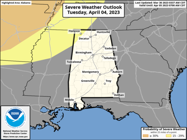
NEXT WEEK: Moisture begins to return Monday, and much of the week looks unsettled with the potential for multiple rounds for rain and storms. Another storm system will bring the risk of severe thunderstorms to the Deep South sometime in the Tuesday/Wednesday time frame, and the SPC has already issued a severe weather threat for the region; way too early to be specific on this threat.
Drier air returns at the end of the week Friday. Highs reach the mid 80s by Tuesday and Wednesday, but should fall back into the 70s to end the week.
BEACH FORECAST CENTER: Get the latest weather and rip current forecasts for the beaches from Fort Morgan to Panama City on our Beach Forecast Center page. There, you can select the forecast of the region that you are interested in visiting.
WORLD TEMPERATURE EXTREMES: Over the last 24 hours, the highest observation outside the U.S. was 112.3F at Diourbel, Senegal. The lowest observation was -85.9F Concordia, Antarctica.
CONTIGUOUS TEMPERATURE EXTREMES: Over the last 24 hours, the highest observation was 91F at Fort Meyers, FL. The lowest observation was -11F at Wakefield, MI.
Category: Alabama's Weather, ALL POSTS
About the Author (Author Profile)
Macon, Georgia Television Chief Meteorologist, Birmingham native, and long time Contributor on AlabamaWX. Stormchaser. I did not choose Weather, it chose Me. College Football Fanatic. @Ryan_StinnetSubscribe
If you enjoyed this article, subscribe to receive more just like it.


