Rare High Risk Areas Added to Day One Severe Weather Outlook
The SPC has added two High Risk areas (level 5/5) to the new Day One, including parts of Iowa, Illinois, and extreme northeastern Missouri, as well as a separate area for southwestern Tennessee, eastern Arkansas, and northern Mississippi.
Here is the text of the Public Severe Weather Outlook:
PUBLIC SEVERE WEATHER OUTLOOK
NWS STORM PREDICTION CENTER NORMAN OK
1139 AM CDT FRI MAR 31 2023
…Outbreak of tornadoes and severe thunderstorms expected over
parts of the portions of the Midwest and the lower MS/TN River
Valleys this afternoon and tonight…
* LOCATIONS…
Illinois
Iowa
Arkansas
Mississippi
Tennessee
Missouri
Kentucky
Alabama
Indiana
Wisconsin
Louisiana
Ohio
* HAZARDS…
Numerous tornadoes, several intense and long track
Widespread damaging winds, some hurricane force
Scattered large hail, some baseball size
* SUMMARY…
A severe weather outbreak appears increasingly likely, centered
on this afternoon and evening, across a large portion of the
Mississippi Valley. At least a few long-track, strong to
potentially violent tornadoes are probable, particularly over
portions of the Mid-Mississippi Valley to the Mid-South. Swaths
of intense damaging wind gusts along with very large hail are
expected as well.
Preparedness actions…
Review your severe weather safety procedures for the possibility
of dangerous weather today. Stay tuned to NOAA Weather Radio,
weather.gov, or other media for watches and warnings. A tornado
watch means that conditions are favorable for tornadoes to form
during the next several hours. If a tornado warning is issued for
your area, move to a place of safety, ideally in a basement or
interior room on the lowest floor of a sturdy building.
&&
..Bentley.. 03/31/2023
For us in Alabama, we have four out of the five risk levels:
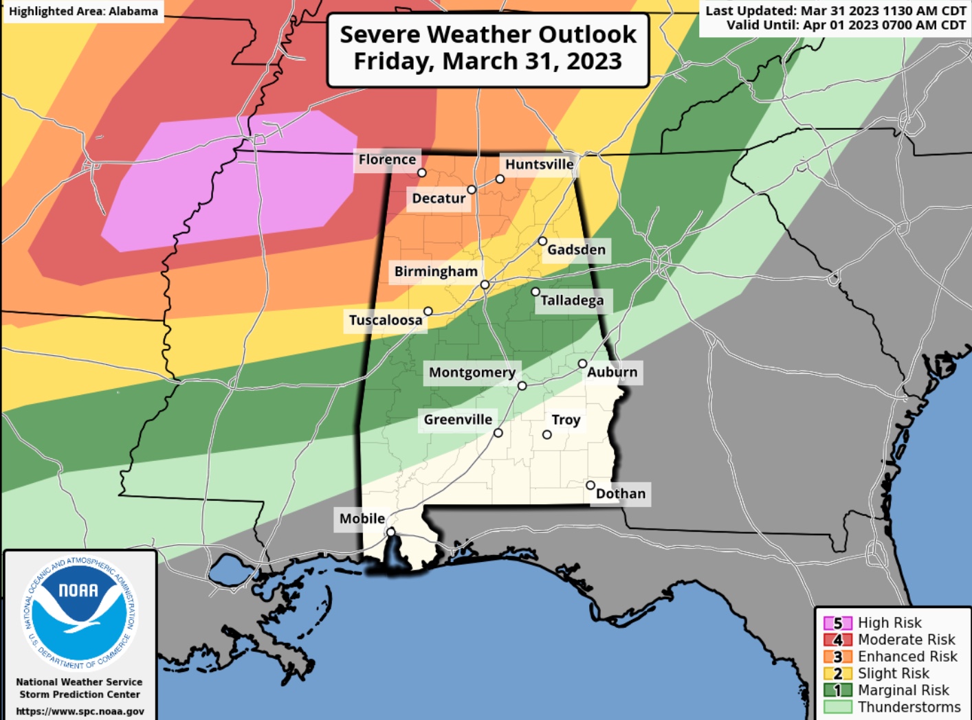
There is a Moderate Risk (level 4/5) for the Quad Cities around Florence and Muscle Shoals. A line of intense thunderstorms should reach the Shoals around 11 pm-midnight. An Enhanced Risk area (level 3/5) is north of a line from Reform to Jasper to Hanceville to Scottsboro. This also includes a higher threat of tornadoes, including the threat of EF2 of greater tornaoes.
Southward to a line from Geiger to Moundville to Pelham to Anniston, there is a Slight Risk (level 2/5), which is the SPC standard risk area. It includes the threat of damaging winds of 60 mph or greater, a slightly lesser chance of tornadoes, and a small risk of large hail.
Beyond that, a Marginal Risk (level 1/5) goes as far south as Pine Hill, Millbrook, and Lafayette. Damaging winds will be the main threat here, with a small chance of a tornado.
Now is the time to review your severe weather safetly plan, set your safety kit out and check your alert reception devices. Monitor the weather closely this evening and overnight into Saturday morning.
Category: Alabama's Weather, ALL POSTS, Severe Weather
About the Author (Author Profile)
Bill Murray is the President of The Weather Factory. He is the site's official weather historian and a weekend forecaster. He also anchors the site's severe weather coverage. Bill Murray is the proud holder of National Weather Association Digital Seal #0001 @wxhistorianSubscribe
If you enjoyed this article, subscribe to receive more just like it.


