

A Late Upgrade to Tonight’s One Severe Weather Outlook over Southwest Alabama
SPC has upgraded tonight’s severe weather outlook to Slight (2/5) over Southwest Alabama in the Mobile area.
Strong storms are expected to form in the next couple of hours along the Louisiana/Mississippi border. They will push eastward reaching the Alabama/Mississippi border counties around Choctaw, Washington, and Clarke Counties around 530-6 a.m. These storms could be severe. Hence the upgrade over southern Mississippi, southeastern Louisiana, and Southwest Alabama.
A large complex of rain and thunderstorms is pushing eastward through the Mississippi Delta at this hour. It extends back into much of Arkansas and northern Louisiana. This activity will move into West Central Alabama around 5 a.m. and will push across Central Alabama through the morning. The rain and storms should reach Birmingham around 7 or 8 a.m.
After the morning activity moves through Central Alabama, additional storms could form between 2-p.m. in areas along and south of I-22 and US-280 or roughly from Hamilton to Birmingham to Alex City to Auburn. Storms that form across Central Alabama during the afternoon could be severe with damaging winds and large hail. Storms northeast of that line should remain subsevere.
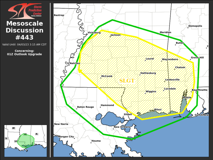
Mesoscale Discussion 0443
NWS Storm Prediction Center Norman OK
1019 PM CDT Sun Apr 02 2023
Areas affected…Southern portions of LA/MS/AL
Concerning…01Z Outlook upgrade
Valid 030319Z – 030815Z
SUMMARY…Portions of southeast Louisiana, southern Mississippi into
southwest Alabama should be considered upgraded from the 01z
Convective Outlook, with a Marginal Risk at the coast and a Slight
Risk over interior areas (see graphic). This is related to
tornado/thunderstorm wind damage potential through the 12z time
frame (and potentially beyond).
DISCUSSION…Concern has increased for the potential, at least on an
isolated/conditional basis, for severe storms overnight across
portions of southeast Louisiana/southern Mississippi and into
southwest Alabama by the predawn hours of Monday. Steady low-level
moistening is expected to occur across the region through the
late-night/early morning hours in tandem with a northward-shifting
warm front. A convectively augmented mid-level vort max will
continue to shift eastward from the ArkLaTex toward the Tennessee
Valley Monday morning, with increasing ascent and strengthening
deep-layer winds progressively influencing the region overnight.
A somewhat separate mesoscale branch of increasingly strong 850
mb/1-2km AGL winds should overspread the region, resulting in
elongating low-level hodographs. Strong/severe storms currently over
northern Louisiana may persist east-southeastward overnight.
Additional storms may develop/increase, at least on a widely
scattered basis, within a near-coastal low-level confluence regime.
With this potential, the expected environmental trends causes
concern for the possibility of supercells, which may include tornado
potential, a bit farther south/southeast that previously thought.
Recent HRRR runs and 00z guidance such as the NSSL-WRF lend credence
to this potential.
..Guyer.. 04/03/2023
Category: ALL POSTS
About the Author (Author Profile)
Bill Murray is the President of The Weather Factory. He is the site's official weather historian and a weekend forecaster. He also anchors the site's severe weather coverage. Bill Murray is the proud holder of National Weather Association Digital Seal #0001 @wxhistorianSubscribe
If you enjoyed this article, subscribe to receive more just like it.


