Unsettled Week Ahead; Strong Storms Possible Later Today
RADAR CHECK: A large mass of rain is moving through Alabama early this morning. Stronger thunderstorms are across South Alabama, where a severe thunderstorm warnings have been needed for some of the counties counties due to the potential for large hail. We expect a dry period later this morning, but more storms will form during the afternoon and evening hours, and those could be strong to severe. SPC has defined a “slight risk” (level 2/5) for areas south of a line from Thomasville to Greenville to Ozark, and a “marginal risk” as far north as Hamilton, Birmingham, and Opelika.
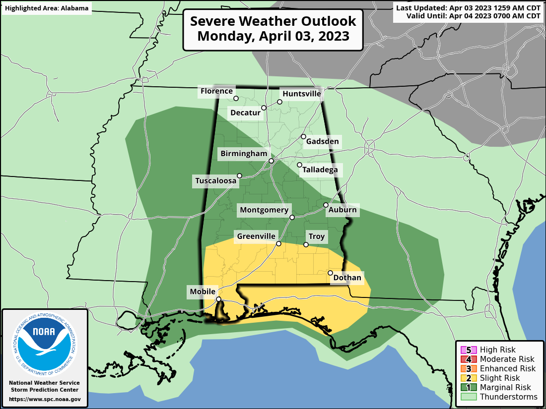
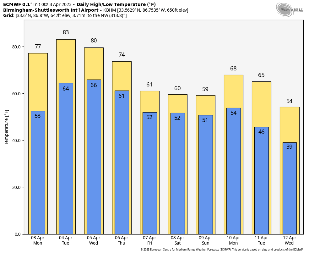
The window for the heavier storms will come from 2:00 until 9:00 p.m.. and the main threats will come from hail and strong winds. However, an isolated tornado or two is possible across South Alabama in the “slight risk”. Expect a high today in the 70s across North Alabama, with 80s for the southern counties.
Tomorrow should be the driest day of the week. With a mix of sun and clouds, temperatures rise into the 80s statewide with only a few isolated afternoon showers or storms. The chance of any one spot getting wet is 10-20 percent.
WEDNESDAY/THURSDAY: Wednesday will be another very warm day with highs in the 80s. An organized band of showers and storms will move into the state late in the day and Wednesday night ahead of a cold front… SPC has defined a “marginal risk” (level 1/5) north of a line from Butler to Hoover to Alexandria.
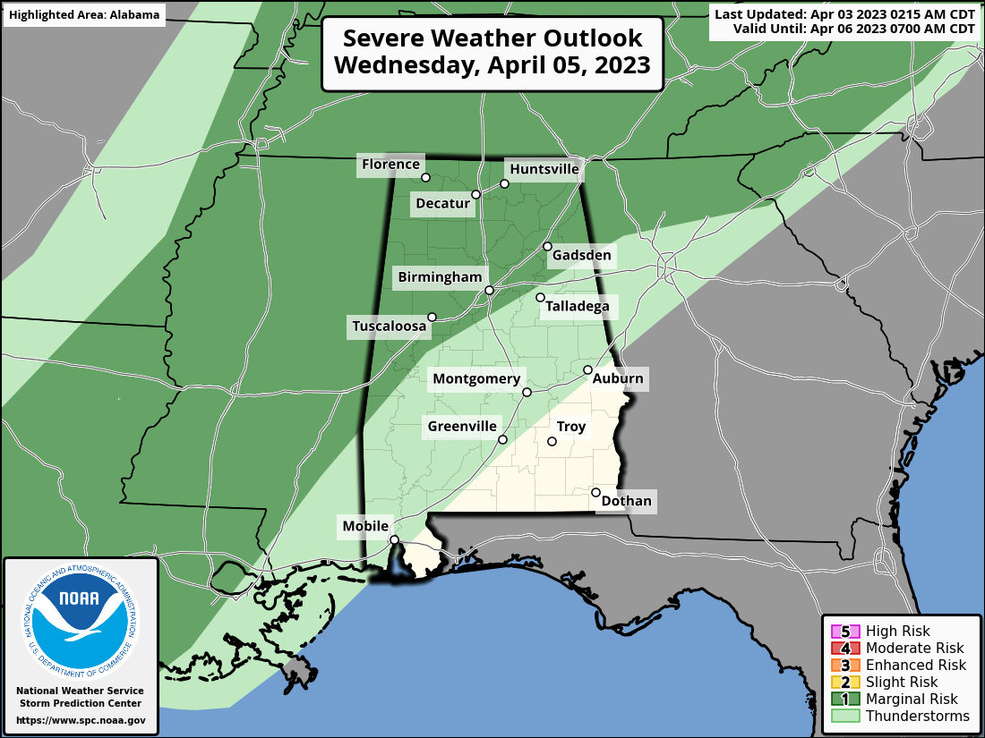
While the upper dynamic support will be lifting far north of Alabama, a few storms Wednesday night could produce strong gusty winds. The tornado threat is very low.
The front will drift into Central Alabama and stall out Thursday. Periods of rain will continue through the day Thursday, and there will be a big thermal contrast with highs in the 60s for North Alabama, 70s for the central counties, and 80s for the southern quarter of the state.
FRIDAY AND THE EASTER WEEKEND: The front remains stalled, and occasional rain is likely Friday and Saturday with the wide temperature spread continuing. The front gets a southward push Sunday; we will keep a chance of rain going for the morning hours, but by afternoon the northern counties of the state should be dry. Some rain will remain possible across South Alabama through the afternoon… highs will be in the 70s.
NEXT WEEK: Model consistency is very poor for next week, leading to a very low confidence forecast. The reliable European model suggests a good shot of colder air at mid-week, with some potential for frost/freezing temperatures for the northern half of the state, but the American GFS model keeps the weather mild. On the positive side we aren’t seeing any severe weather signals for now… See the video briefing for maps, graphics, and more details.
ON THIS DATE IN 1974: The 1974 Super Outbreak underway. It was the second-largest tornado outbreak on record for a single 24-hour period, just behind the 2011 Super Outbreak. It was also the most violent tornado outbreak ever recorded, with 30 F4/F5 tornadoes confirmed. From April 3–4, 1974, there were 148 tornadoes confirmed in 13 U.S. states and the Canadian province of Ontario.
In Alabama, at least eight tornadoes, including four extremely intense and long-lived storms, brought death and extreme storm destruction that night. The communities of Guin and Jasper were hit hard. Eighty-six persons were killed, 949 were injured.. Sixteen counties in the northern part of the state were hit the hardest. It ranks as the third deadliest tornado outbreak in Alabama history. It is surpassed by the tornado outbreak of March 21, 1932, when over 300 people died in a series of tornadoes, as well as the historic outbreak of April 27, 2011, when 252 Alabamians lost their lives.
BEACH FORECAST: Click here to see the AlabamaWx Beach Forecast Center page.
Look for the next video briefing here by 3:00 this afternoon… enjoy the day!
Category: Alabama's Weather, ALL POSTS, Weather Xtreme Videos
About the Author (Author Profile)
James Spann is one of the most recognized and trusted television meteorologists in the industry. He holds the AMS CCM designation and television seals from the AMS and NWA. He is a past winner of the Broadcast Meteorologist of the Year from both professional organizations.Subscribe
If you enjoyed this article, subscribe to receive more just like it.


