Midday Nowcast: Sunny and Warm for North/Central Alabama
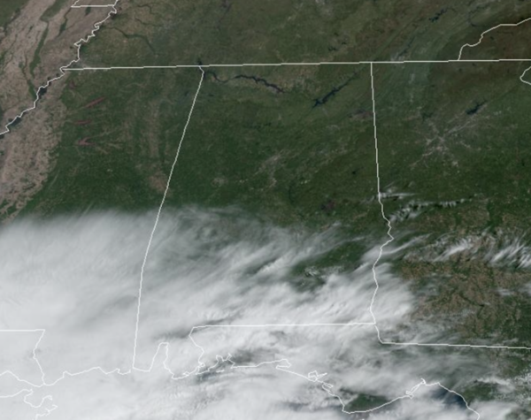
Another incredible spring day for most of Alabama today, with ample sunshine and afternoon temperatures in the mid to upper 70s. Enjoy today, because rain will return tomorrow. In fact, locations along the Alabama and Northwest Florida Gulf coast are already seeing more clouds and increasing rain and storms due to a low in the northern Gulf of Mexico. The low begins to move north tonight, and could allow for a few severe storms along the immediate coast this evening and overnight. There is a “marginal risk” (level 1/5) of severe storms as a few storms could produce gusty winds. A brief waterspout or tornado can’t be ruled out.
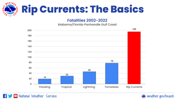
Also along the coast, rip current risk remain very high, and many beaches have Double Red Flags flying, which means the waters are closed to swimmers. In case you didn’t know, rip currents are the number one weather-related killer along the northern Gulf Coast.
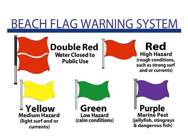
This includes all the beaches of Alabama: Dauphin Island, Ft. Morgan, Gulf Shores, Orange Beach continuing east through the Florida Panhandle: Pensacola Beach, Navarre Beach, Destin, Ft. Walton, 30A, and Panama City Beach. Please, anytime you head to those beautiful beaches to pay attention to the flag warning system, life guards, and beach patrol.
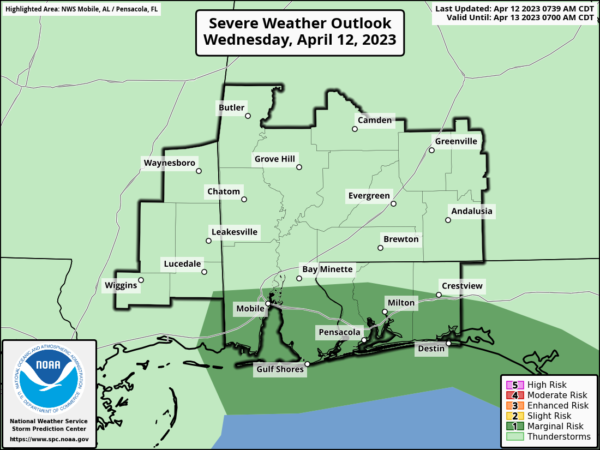
RAIN RETURNS: As the Gulf low moves northward tomorrow, widespread rain and storms will move return to Alabama. The SPC has expanded the low end “marginal risk” (level 1/5) of severe thunderstorms tomorrow for most of Alabama.
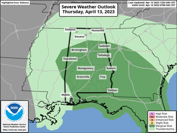
A few storms tomorrow afternoon, during peak daytime heating, could produce small hail and gusty winds. A brief, isolated tornado can’t be totally ruled out, but isn’t likely. It won’t rain all day, but make plans to keep the rain gear close as rain and storms will be possible at anytime. Highs tomorrow will be in the low 70s. The widespread rain will end late tomorrow night, but a few lingering scattered showers are possible Friday over the northern half of the state, as the low continues to pull away. A decent part of the day Friday will be dry with highs in the 70s.
WEEKEND WEATHER: Saturday will be a warm, dry day with more sun than clouds and highs in the low to mid 80s. Late Saturday night and early Sunday, a front will push a band of rain and thunderstorms into the state. The storms could be strong as they push into the northwest corner of the state with some potential for hail, but they will be weakening quickly during as they push southeast through the night. The overall severe weather threat for the rest of the state is very low. Most of the rain will end early Sunday, as the sky becomes mainly sunny by the afternoon. Highs will be in the upper 60s to lower 70s.
NEXT WEEK: Behind the front, a dry airmass will settle into the state Monday and looks to linger through midweek. The first half to the week looks dry and pleasant with mild afternoons and cool nights. Highs Monday will be in the 70s, and we should see 80s the rest of the week.
BEACH FORECAST CENTER: Get the latest weather and rip current forecasts for the beaches from Fort Morgan to Panama City on our Beach Forecast Center page. There, you can select the forecast of the region that you are interested in visiting.
WORLD TEMPERATURE EXTREMES: Over the last 24 hours, the highest observation outside the U.S. was 112.1F at N’Guigmi, Niger. The lowest observation was -92.6F Amundsen-Scott South Pole Station, Antarctica.
CONTIGUOUS TEMPERATURE EXTREMES: Over the last 24 hours, the highest observation was 102F at Cibola, AZ. The lowest observation was 12F at Peter Sinks, UT.
Category: Alabama's Weather, ALL POSTS
About the Author (Author Profile)
Macon, Georgia Television Chief Meteorologist, Birmingham native, and long time Contributor on AlabamaWX. Stormchaser. I did not choose Weather, it chose Me. College Football Fanatic. @Ryan_StinnetSubscribe
If you enjoyed this article, subscribe to receive more just like it.


