Sunday Weather Briefing — Scattered Showers & Storms Each Day Through the Forecast Period
We’ll have a weak front working into the northern parts of the area, and it will eventually stall out. Scattered showers and storms will start developing with the heating of the day and will move in a southerly direction. One or two storms may become strong with gusty winds this afternoon, but widespread severe weather is not expected. It will be a hot one today as highs reach the upper 80s to the lower 90s.
The stalled front will be the catalyst for more scattered showers and storms on Monday, especially over the northeastern parts of the area. We’ll remain hot, as highs will be in the upper 80s to the lower 90s.
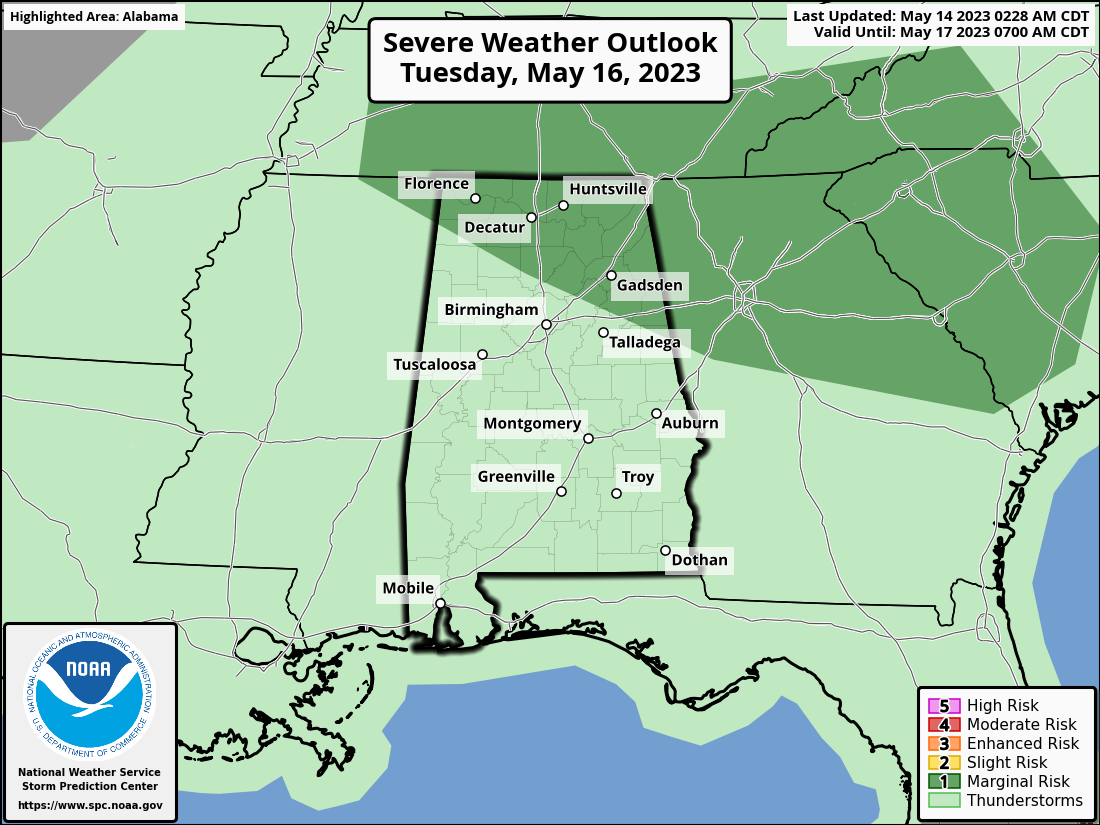
Another weak front will push into the area on Tuesday that will set the stage for showers and storms once again, but this time will be higher in coverage. Some strong storms are expected and the SPC has issued a Marginal Risk along and north of a line from Phil Campbell to Springville to just north of Wedowee, as isolated damaging winds will be the threat. Highs in the mid to upper 80s.
The front will slowly move across the southern portions of the area on Wednesday that will keep a good chance of scattered showers and storms in the forecast along and south of the front, with fewer chances north. Highs in the 80s.
Thursday will feature more scattered showers and storms as a short wave is modeled to move across Central Alabama. Highs in the 80s.
Friday looks to be the driest day of the week as we’ll be in-between systems. Only a very small chance of an isolated shower or two during the afternoon hours. We’ll have partly to mostly sunny skies, with highs in the 80s.
And at the end of the forecast period on Saturday… a front pushes into and through the area, bringing showers and thunderstorms. For now, activity looks to be scattered in nature, but we’ll keep an eye on it for the possibility of strong storms. Highs mostly in the lower to mid 80s.
That will do it for today’s video. We’ll have notes on the blog throughout the day. Spann will be back tomorrow morning with the next video. I’m meteorologist Scott Martin. Have a great day and God bless.
Category: Alabama's Weather, ALL POSTS, Severe Weather, Weather Xtreme Videos
About the Author (Author Profile)
Scott Martin is an operational meteorologist, professional graphic artist, musician, husband, and father. Not only is Scott a member of the National Weather Association, but he is also the Central Alabama Chapter of the NWA president. Scott is also the co-founder of Racecast Weather, which provides forecasts for many racing series across the USA. He also supplies forecasts for the BassMaster Elite Series events including the BassMaster Classic.Subscribe
If you enjoyed this article, subscribe to receive more just like it.


