

Midday Nowcast: Another Stormy Afternoon
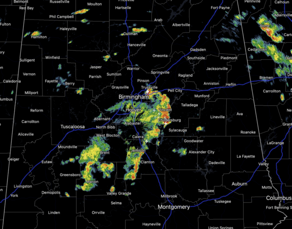
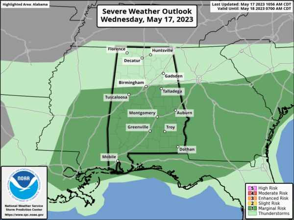
More showers and storms are ongoing today and some of them will pack a punch as the SPC maintains a “marginal risk” (level 1/5) of severe thunderstorms for about the southern 2/3 of the state. Stronger storms this afternoon and evening will be capable of producing strong, gusty winds, small hail, heavy rain, and lots of lighting.
As in recent days, these tropical downpours can lead to areas of isolated flash flooding. In between and around the storms, it will be mainly cloudy, very muggy, with afternoon temperatures ranging from the upper 70s to lower 80s.
TOMORROW/FRIDAY: Scattered showers and storms are likely again tomorrow, as a weak surface boundary remains in place. By Friday, the boundary will be closer to the Gulf Coast, and that should allow for fewer showers and storms for the northern half of the state. Highs will remain in the upper 70s and low 80s, which is below average for mid-May in Alabama.
WEEKEND WEATHER: A surface front will pass through the state Saturday, and another batch of showers and thunderstorms is likely. It won’t rain all day, and it won’t rain everywhere. Saturday’s high will remain close to 80°. On Sunday, a drier, continental airmass will drop into the state, bringing lower humidity and a mostly sunny sky. The high Sunday will be in the low 80s and it will feel very comfortable.
INTO NEXT WEEK: Look for pretty routine late May weather with a mix of sun and clouds and some widely, scattered showers and storms, mainly during the afternoon and evening hours. Daily rain chances will be in the 20-30% range and afternoon highs generally in the 80s.
BEACH FORECAST CENTER: Get the latest weather and rip current forecasts for the beaches from Fort Morgan to Panama City on our Beach Forecast Center page. There, you can select the forecast of the region that you are interested in visiting.
WORLD TEMPERATURE EXTREMES: Over the last 24 hours, the highest observation outside the U.S. was 114.3F at Bilma, Niger. The lowest observation was -95.1F Concordia, Antarctica.
CONTIGUOUS TEMPERATURE EXTREMES: Over the last 24 hours, the highest observation was 109F at Death Valley, CA. The lowest observation was 16F at Mount Washington, NH.
Category: Alabama's Weather, ALL POSTS
About the Author (Author Profile)
Macon, Georgia Television Chief Meteorologist, Birmingham native, and long time Contributor on AlabamaWX. Stormchaser. I did not choose Weather, it chose Me. College Football Fanatic. @Ryan_StinnetSubscribe
If you enjoyed this article, subscribe to receive more just like it.


