Sunday AlabamaWX Weather Briefing: A Wedge This Week
Storms formed Saturday afternoon ahead of a cold front that moved through Alabama overnight. That front is is lying over Southeast Alabama early on this Sunday morning. Despite decent instability, the storms stayed generally below severe limits. The front will exit the state by noon, perhaps triggering a few storms in its vicinity.
FOR YOUR SUNDAY: We are starting the day mostly cloudy to partly sunny, except over Northwest Alabama where enough dry air has worked its way in to produce a sunny start to the day. Temperatures are beginning the day in the 50s over North Alabama with lower and middle 60s across the Central part of the state. Everyone should be dry today, with the exception of the aforementioned showers over the Wiregrass, You should see a decent supply of sunshine for a short period during the day, but clouds will thicken once again by afternoon as Atlantic moisture gets pulled in from the east. Afternoon readings will be in the upper 70s Northwest, with mostly lower 80s elsewhere. Under mostly cloudy skies tonight, lows will drop into the 50s North once again, with 60s to the south.
SHOWERS MAKE A COMEBACK: Our airmass never really changes and with the Atlantic moisture moving in late today and tomorrow, a chance of rain and some isolated thunder will return for your Monday. Highs will be a few degrees cooler than those of today thanks to the clouds and precipitation. The precipitation chances will be with us through the overnight hours, but the rain showers should begin to diminish by Tuesday as a wedge muscles its way in from the northeast. It will be cooler Tuesday and a little breezy with that wedge in place. Look for highs in the 70s areawide.
MIDWEEK AND BEYOND: The wedge will be reinforced by a large anticyclone over the Great Lakes by Wednesday. It will remain breezy Wednesday, but highs will edge back up into the 80s. Thursday, Friday, Saturday, and Sunday should be mostly rain free, although we can’t rule out a passing shower with any cool fronts that get propelled into from the northeast by the big ridge to the north. Highs through the period will be in the lower and middle 80s, with overnight lows centered around 60F.
VOODOO COUNTRY: A fairly strong subtropical ridge will project Alabama from any wet weather through much of the Week Two period, although showers and storms may show back up by late Thursday and Friday as the ridge breaks down. It will become quite warm, with some signs that highs may reach well into the 90s by the last few days of May and the first few days of June. Not a good sign.
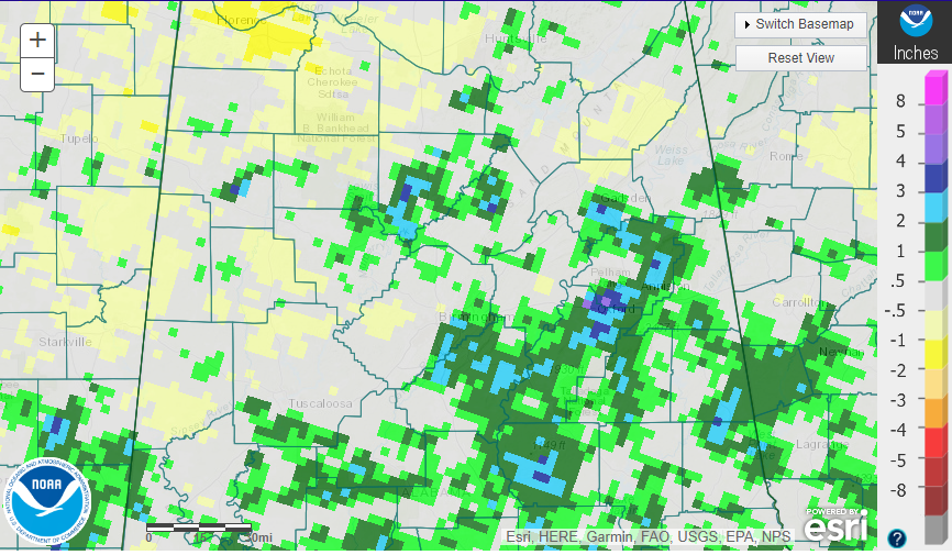
LAWN AND GARDEN OUTLOOK: Recent rains have helped to alleviate the dryness in some areas, including southern Jefferson and Shelby Counties.
But lots of other areas were still dry. Here are rainfall anomalies over the past 7 days:
BEACHCAST: Widely scattered showers and storms will be a part of the forecast for the foreseeable future along the beautiful beaches of Alabama and Northwest Florida. But rain chances will be elevated especially Monday, Tuesday, and Wednesday this week with this old front hanging around. Highs will be in the 8-s all week, with lows in the 70s until midweek, when cooler Canadian high pressure will take over, dropping those overnight readings into the more refreshing 60s. Water temperatures are running in the comfortable upper 70s. The rip current risk will be low through the early part of the week, but will be in the moderate risk again from midweek on.
Click here to see the Beach Forecast Center page.
NATIONALLY: The country as a whole is rather calm with only a few flood warnings and a couple of flash flood watches in effect. Severe weather today will be limited to the northern Rockies, including parts of eastern Oregon and Washington, parts of Idaho, and western Montana.
DANCING WITH THE STATS: 0.82” of rain yesterday at Flagstaff AZ was a record for the date as an unusual monsoon-like pattern has been affecting the Southwest. The only severe weather across the country today will be over the northern Rockies, including parts of eastern Oregon and Washington into Idaho and extreme western Montana.
ADVERTISE WITH US: Deliver your message to a highly engaged audience by advertising on the AlabamaWX.com website. We have a lot of big plans for this year. Don’t miss out! We can customize a creative, flexible, and affordable package that will suit your organization’s needs. Contact me, Bill Murray, at (205) 687-0782 and let’s talk.
WEATHERBRAINS: This week, the panel will entertain Sam Lashley, who will be providing weather support for the Indianapolis 500. Our very own race weather expert Scott Martin will be joining as well! Be sure to catch the show wherever you get your podcasts. You can also check out the show at www.WeatherBrains.com and watch live at on our YouTube channel for the show.You will be able to see the show on the James Spann 24×7 weather channel on cable or directly over the air on the dot 2 feed.
ON THIS DATE IN 2001: Tristan da Cunha, a remote island in the South Atlantic, was ravaged by a powerful tropical cyclone. The resilient community of 300 faced unimaginable destruction, but through unity and resilience, they rebuilt their lives. A testament to the human spirit! Follow my weather history tweets on Twitter. I am @wxhistorian at Twitter.com.
Category: Alabama's Weather, ALL POSTS, Weather Xtreme Videos
About the Author (Author Profile)
Bill Murray is the President of The Weather Factory. He is the site's official weather historian and a weekend forecaster. He also anchors the site's severe weather coverage. Bill Murray is the proud holder of National Weather Association Digital Seal #0001 @wxhistorianSubscribe
If you enjoyed this article, subscribe to receive more just like it.


