Midday Nowcast: New Day, Same Forecast
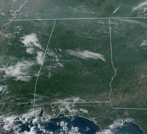
Today and tomorrow, expect more of the same with partly to mostly sunny days and highs in the upper 80s to lower 90s, which is close to average for this time of year. During the peak heating of the day, we will have random, widely scattered showers and thunderstorms that form. Many places won’t see a drop, but some communities will experience a heavy storm with potential for small hail and strong gusty winds. The chance of any one specific location seeing a shower or thunderstorm both days is in the 20-30% range, and most of the activity will come from 2-10PM.
ACROSS THE USA: Air Quality Alerts and Fire Weather concerns will continue for the Great Lakes and Northeast through today. Meanwhile, the pattern for the west remains unsettled with more showers and thunderstorms and locally heavy rainfall continues through the middle of this week. Warming temperatures will climb above seasonable normal values for the Pacific Northwest and northern Plains through Thursday.
FRIDAY AND THE WEEKEND: Much drier air will drop into the state Friday and Saturday; on these two days we expect a mostly sunny sky. Rain chances will be near zero, and nights will be a bit cooler, some spots could reach the 50s early Friday and Saturday morning. On Sunday, moisture levels rise and we will bring back the chance of “scattered, mostly afternoon and evening showers and thunderstorms” with a mix of sun and clouds. Highs will remain in the upper 80s and low 90s.
NEXT WEEK: A persistence forecast is what we will go with for much of the week. Partly sunny days with the chance of a passing afternoon thunderstorm in scattered spots. By midweek, it looks like a warming trend will begin as a ridge builds in over the Deep South, meaning hotter temperatures as mid 90s are possible.
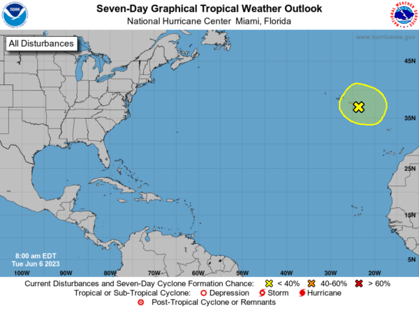
IN THE TROPICS: All is quiet in the Gulf of Mexico, Caribbean Sea, and most of the Atlantic. But a non-tropical area of low pressure located between the Azores and Canary Islands is producing disorganized showers and thunderstorms with winds to gale force over the northeastern Atlantic Ocean. This system could acquire some subtropical characteristics during the next day or so while it meanders to the east and southeast of the Azores. By late Wednesday, the system is forecast to move northeastward over cooler waters, and further development is not expected. Regardless of development, heavy rains and gusty winds will continue across portions of the Canary Islands, Madeira Island, and the Azores over the next day or so. Formation chance through 48 hours…low…10 percent. Formation chance through 7 days…low…10 percent. Next name up is Bret.
BEACH FORECAST CENTER: Get the latest weather and rip current forecasts for the beaches from Fort Morgan to Panama City on our Beach Forecast Center page. There, you can select the forecast of the region that you are interested in visiting.
WORLD TEMPERATURE EXTREMES: Over the last 24 hours, the highest observation outside the U.S. was 116.2F at Basrah International Airport, Iraq. The lowest observation was -105.2F Concordia, Antarctica.
CONTIGUOUS TEMPERATURE EXTREMES: Over the last 24 hours, the highest observation was 108F at Death Valley and Stovepipe Wells, CA. The lowest observation was 27F at Peter Sinks, UT.
Category: Alabama's Weather, ALL POSTS
About the Author (Author Profile)
Macon, Georgia Television Chief Meteorologist, Birmingham native, and long time Contributor on AlabamaWX. Stormchaser. I did not choose Weather, it chose Me. College Football Fanatic. @Ryan_StinnetSubscribe
If you enjoyed this article, subscribe to receive more just like it.


