Make Sure You Have Multiple Ways to Receive Warnings Overnight
Even as I wrote this update, the SPC was putting up Mesoscale Discussions for areas to our west and northwest…they are worth reading as they emphasize these same concerns. The SPC watches are coming soon to our west, including the likelihood of a tornado watch.
Things are calm across Alabama right now. A line of showers is pushing northeast from Decatur to Oneonta to Talladega. They are likely forming on the leading edge of the developing warm air advection riding on a low level jet that is building over Mississippi and western Alabama.
We are watching radars to the west and northwest over Arkansas, northern Mississippi, and western Tennessee. Showers and storms should start breaking out over the next coule of hours and they should rapidly intensify in a prime environment for severe weather.
A shortwave trough moving out of Missouri into our neighboring states to the west and northwest will bring slightly cooler temperatures aloft and increased vorticity or spin in the atmosphere to enhance the instability and help initiate the storms.
Several factors seems to point to a tornado threat this evening and into the overnight, including very favorable Lifted Condensation Levels, a key factor in tornado development in the south. Instability values will be approaching 2,000-2,5000 joules over Mississippi and western Alabama later this evening. There is plenty of bulk shear with the convective allowing models showing a decent low level jet developing over the region at 850 mb or 5,000 feet. 50-60 knot winds in the jet will give plenty of shear for organized storms.
We expect the storms to be moving into eastern Mississippi by 11 p.m. this evening. There could be a couple of significant tornadoes over Mississippi, generally between Vicksburg, Columbus, and Greenwood.
The storms will move into Alabama around midnight and reach the Birmingham area before 2 a.m. They will move into East Central Alabama between 3-4 a.m.
But I fear we could see a tornado or two over western sections of Alabama generally west of I-65 and south of I-22. Places like Pickens, Sumter, Lamar, Fayette, Walker, and Tuscaloosa Counties need to be especially alert. Counties to the east like Jeffeson, Shelby, Bibb and Chilton, as well as counties to the south like Dallas and Perry should pay close attention to this developing situation.
Hopefully they will be weakening after midnight and one would expect them to, but a well developed low level jet could cause them to overperform.
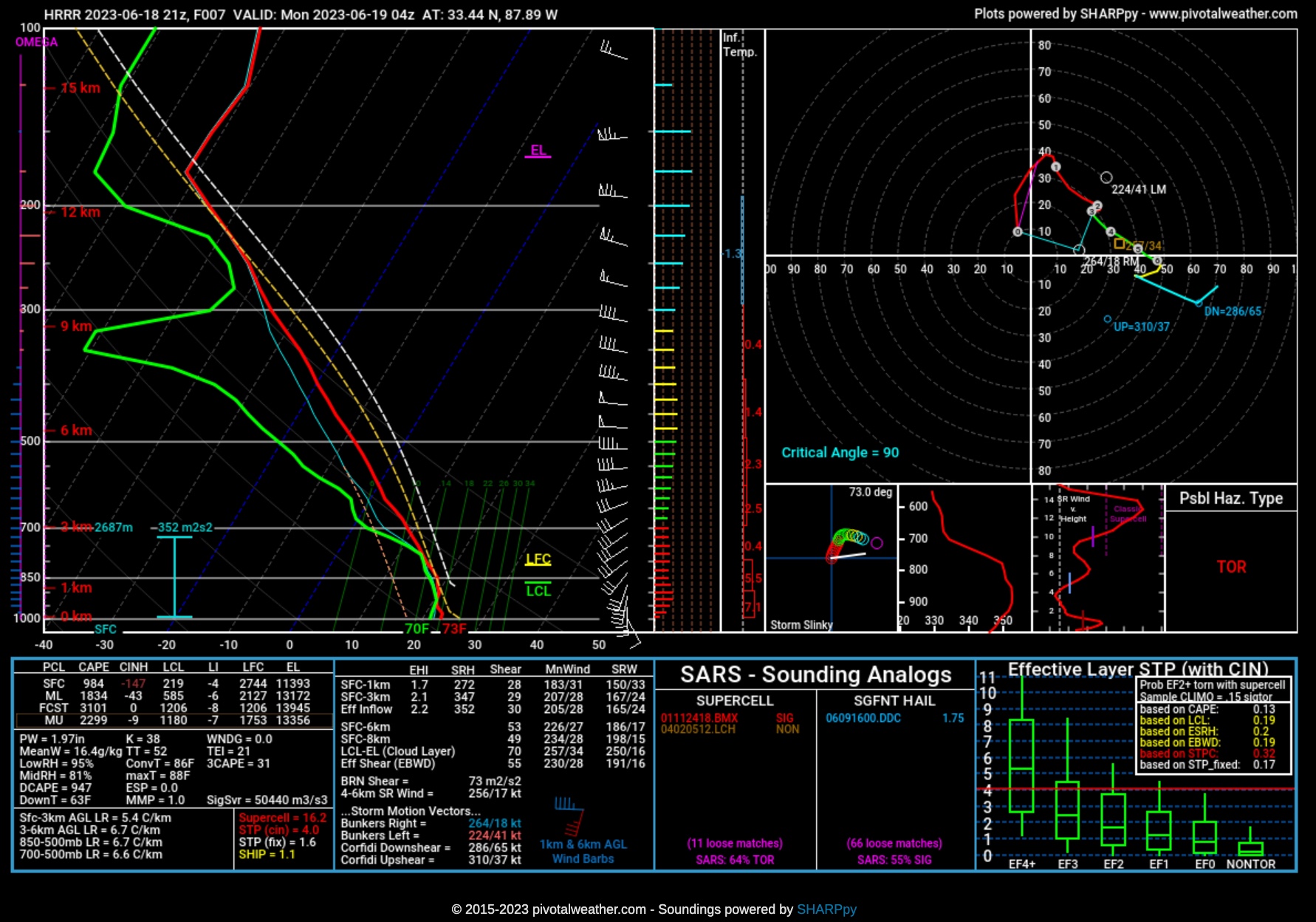
A forecast sounding off the HRRR over West Central Alabama in Northern Pickens around 11 p.m. shows definite potential for a tornado with 2,400 joules of CAPE and 51 knots of bulk shear as well as 278 m2/s2 of 0-1km storm relative helicity. Longer term blog audience members knows that is like a high energy sports drink for a supercell.
The storms should exit the state mostly by 7a.m. but won’t be entirely out of the state until 9-10 a.m.
So, I know you are tired of hearing it, but make sure to have multiple warning sources that will wake you in the middle of the night and be ready to act if a warning is issued for your location.
Category: Alabama's Weather, ALL POSTS, Severe Weather
About the Author (Author Profile)
Bill Murray is the President of The Weather Factory. He is the site's official weather historian and a weekend forecaster. He also anchors the site's severe weather coverage. Bill Murray is the proud holder of National Weather Association Digital Seal #0001 @wxhistorianSubscribe
If you enjoyed this article, subscribe to receive more just like it.


