A Couple of Watches Coming Soon to our West, Including a Tornado Watch Says SPC
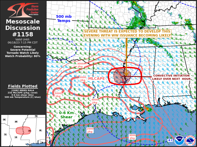
Mesoscale Discussion 1158
NWS Storm Prediction Center Norman OK
0611 PM CDT Sun Jun 18 2023
Areas affected…Far Southeast Arkansas…Northeast
Louisiana…Western and Central Mississippi
Concerning…Severe potential…Tornado Watch likely
Valid 182311Z – 190015Z
Probability of Watch Issuance…80 percent
SUMMARY…A severe threat will likely develop across parts of the
lower Mississippi Valley early this evening. A potential for wind
damage, large hail and tornadoes are expected to develop. Weather
watch issuance will likely be needed.
DISCUSSION…Water vapor imagery currently shows west-northwesterly
mid-level flow over the lower Mississippi Valley, with a 700 mb
speed max of 40 to 50 knots located in southwest Arkansas. At the
surface, a trough is located from northeast Texas into south-central
Arkansas. Ahead of this feature, surface dewpoints are mostly in the
70s F. This is contributing to moderate to strong instability, with
the RAP estimating MLCAPE in the 3000 to 5000 J/kg range. In spite
of the instability, large-scale ascent is weak across much of the
region. However, as low-level convergence increases along the
surface trough and southward into northern Louisiana early this
evening, convective initiation will become likely. Based on cam
guidance, storms appear likely to initiate over the next couple of
hours. The 21Z sounding at Jackson, Mississippi has 0-6 km shear
near 60 kt with 0-3 km storm relative helicity near 400 m2/s2. As
the storms grow upscale, supercells with large hail and wind damage
will become likely. A tornado threat is also expected to develop.
..Broyles/Grams.. 06/18/2023
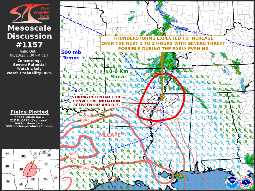
Mesoscale Discussion 1157
NWS Storm Prediction Center Norman OK
0531 PM CDT Sun Jun 18 2023
Areas affected…Eastern Arkansas…Far Southwest
Tennessee…Northwest and North-central Mississippi
Concerning…Severe potential…Watch likely
Valid 182231Z – 190030Z
Probability of Watch Issuance…80 percent
SUMMARY…The severe threat is expected to gradually increase across
northeastern Arkansas and may impact areas further south across
eastern Arkansas and northwest Mississippi, especially as convective
initiation becomes more likely. Weather watch issuance will be
likely over the next couple of hours.
DISCUSSION…The latest water vapor imagery shows an upper-level
trough over the Ozarks. At the surface, a moist airmass is located
across much of the lower to mid Mississippi Valley. The RAP has
moderate instability across southeastern Arkansas and north-central
Mississippi with weaker instability further north into northeast
Arkansas and western Tennessee. A severe threat has recently
developed in far northeast Arkansas, near a mid-level vorticity max
associated with the upper-level trough. The severe threat will
likely continue as storms gradually intensify southward across
northeast Arkansas. As the vorticity max moves east-southeastward,
additional convective initiation is expected from east-central
Arkansas eastward across northwest Mississippi. The moderate
instability, strong deep-layer shear and strengthening low-level
shear will make supercell development possible later this evening.
Large hail and wind damage will initially be possible, but an
tornado threat may also eventually develop especially across
northern Mississippi.
..Broyles/Grams.. 06/18/2023
Category: Alabama's Weather, ALL POSTS, Severe Weather
About the Author (Author Profile)
Bill Murray is the President of The Weather Factory. He is the site's official weather historian and a weekend forecaster. He also anchors the site's severe weather coverage. Bill Murray is the proud holder of National Weather Association Digital Seal #0001 @wxhistorianSubscribe
If you enjoyed this article, subscribe to receive more just like it.


