Invest 92L Likely to Become Depression Soon and Bret Early in the Week
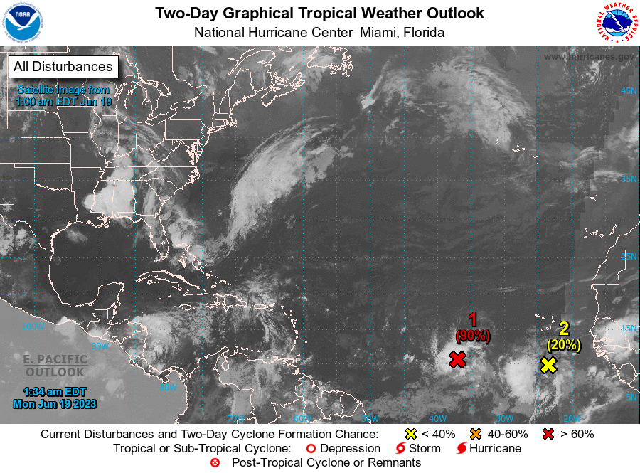
Invest 92-L is expected to develop into a tropical cyclone in the eastern Atlantic over the next couple of days. That is a very unusual situation, as the eastern Atlantic is not usually favorable for development in June. But water temperatures are very warm, dry Saharan air is absent, and vertical shear is low. This means gradual development is expected.
Early on this Monday morning, convection does seem to be increasing, as does outflow, and a tropical depression may be forming near 40W or about 1,200 miles east of the Lesser Antilles.
The GFS has been very aggressive and quick with development, but it is biased in that direction historically. So the system will likely develop more slowly than the GFS thinks, and a weaker system is less likely to feel the pull of the trough to the north that could recurve it.
The GFS has it a pretty strong hurricane, and is supported by the HWRF and HAFS models. But these models also tend to be very aggressive before the cyclone actually develops.
In any case, we should have a tropical depression later today or Tuesday. It looks like a tropical storm will form by about Tuesday night or Wednesday morning in the central Tropical Atlantic.
The Latest Model Guidance seems to suggest that the idea of Invest 92-L turning to the north before reaching the Caribbean is becoming less of a possibility. Instead, model guidance consensus seems to point towards a track to the west and west-northwest and for Invest 92-L to affect the Leeward Islands, the Virgin Islands and Puerto Rico around Friday or so.
Beyond this, we should probably see this system head on a west-northwestward track taking it over the southern and central Leeward Islands in the vicinity of Dominica and Guadeloupe as perhaps a 50-60 mph tropical storm during the day on Friday.
From there, weakening to a depression seems quite possible next week as this system tracks into the northeastern Caribbean in the vicinity of Puerto Rico and Hispaniola. It could die over the graveyard of the eastern Caribbean, so called because of unfavorable wind patterns early in the hurricane season.
There is some chance that if it is stronger, it would likely respond to a trough that will be passing north of the Bahamas this week, opening a door for the stranger system to recurve.
It will be interesting to watch.
Category: Tropical
About the Author (Author Profile)
Bill Murray is the President of The Weather Factory. He is the site's official weather historian and a weekend forecaster. He also anchors the site's severe weather coverage. Bill Murray is the proud holder of National Weather Association Digital Seal #0001 @wxhistorianSubscribe
If you enjoyed this article, subscribe to receive more just like it.


