Midday Nowcast: Wet at Times; Tropical Depression Three Forms
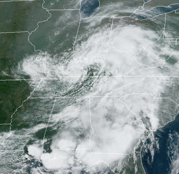
An upper low over the region will keep the weather unsettled through most of the week with the chance of occasional showers and storms. Unlike last week, we should not see as much severe weather, but still scattered strong storms are possible daily, with gusty winds and hail. The greater chance for stronger storms this week will be along the Gulf Coast. The main issue this week will continue to be heavy rainfall as moisture levels remain high. We will have to keep an eye on possible areas of isolated flash flooding.
When it is not raining, the days will be mostly cloudy with highs in the mid to upper 80s…a few degrees below average for mid to late June in Alabama. Rain chances the next several days will be in the 60-80% range, so keep the umbrella close.
FRIDAY AND THE WEEKEND: Towards the end of the week, the upper low begins to pull out towards the northeast. Rain chances will come down some, but still expect widely scattered showers and storms with a partly sunny sky. Highs will be around 90° these days.
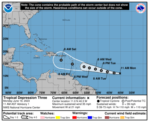
IN THE TROPICS: Getting active in the Atlantic early this season as sea surface temperatures are well-above average for this time of year, which will at least provide plenty of fuel for any potential system.
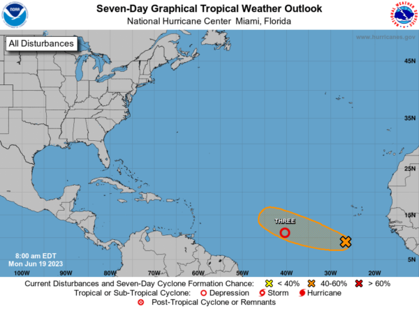
Soon to be Bret, we now have newly formed Tropical Depression Three. At 1100 AM AST, the center of Tropical Depression Three was located near latitude 11.0 North, longitude 40.3 West. The depression is moving toward the west near 21 mph, and this motion is expected to continue for the next several days. On the forecast track, the system should be approaching the Lesser Antilles late this week. Maximum sustained winds are near 35 mph with higher gusts. Some strengthening is forecast, and the depression is forecast to become a hurricane in a few days. The estimated minimum central pressure is 1009 mb (29.80 inches).
Behind this feature, showers and thunderstorms have increased in association with a tropical wave located several hundred miles south-southwest of the Cabo Verde Islands. Further development of this system is possible, and a tropical depression could form within the next few days while the system moves westward at 10 to 15 mph across the eastern and central tropical Atlantic. Formation chance through 7 days…medium…40 percent. The next name up would be Cindy.
BEACH FORECAST CENTER: Get the latest weather and rip current forecasts for the beaches from Fort Morgan to Panama City on our Beach Forecast Center page. There, you can select the forecast of the region that you are interested in visiting.
WORLD TEMPERATURE EXTREMES: Over the last 24 hours, the highest observation outside the U.S. was 121.6F at Zabol, Iran. The lowest observation was -83.0F Amundsen-Scott South Pole Station, Antarctica.
CONTIGUOUS TEMPERATURE EXTREMES: Over the last 24 hours, the highest observation was 114F at Falcon Lake, TX. The lowest observation was 25F at Evaro, MT.
Category: Alabama's Weather, ALL POSTS
About the Author (Author Profile)
Macon, Georgia Television Chief Meteorologist, Birmingham native, and long time Contributor on AlabamaWX. Stormchaser. I did not choose Weather, it chose Me. College Football Fanatic. @Ryan_StinnetSubscribe
If you enjoyed this article, subscribe to receive more just like it.


