Midday Nowcast: Showers, Storms, & Active Atlantic
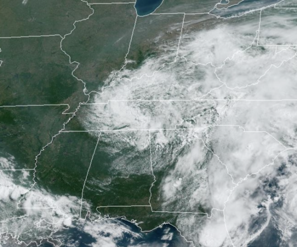
An upper low is dropping south from the Ohio Valley into the Tennessee Valley, and it will keep our weather unsettled the next few days. Rain will be possible at anytime, but it won’t rain all the time or everywhere. The greatest coverage of showers and storms will come during the afternoon and evening hours. A few strong storms are possible, with gusty wind and small hail, but the overall severe weather threat remains very low. The main issues with any storms this week will be tremendous amounts lightning and torrential tropical downpours. Due to the clouds and higher rain chances, we are seeing below average temperatures with highs in the low to upper 80s this week.
SWELTERING TEXAS: Record breaking heat in Texas caused by a stationary upper-level ridge will continue for the next several days. High temperatures will be in the 100s and 110s across southern Texas. There will be little respite in the evenings as lows only drop into the 70s and 80s. Excessive Heat Warnings and Heat Advisories are in effect for much of Texas as a result.
FRIDAY AND THE WEEKEND: On Friday, the upper low begins to lift back north out of the region, decreasing our rain chances for Friday and the weekend. We will still have scattered afternoon showers and storms daily, but the coverage will be less. Expect a partly sunny sky, hot and humid conditions as highs return to the lower 90s.
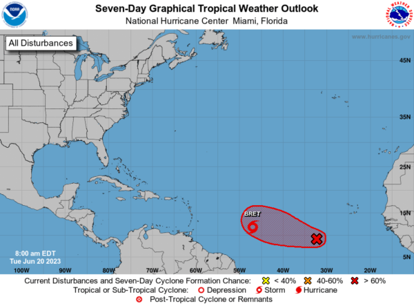
IN THE TROPICS: Bret and soon to be Cindy, which is Invest 93-L: Showers and thunderstorms are gradually showing signs of organization in association with a tropical wave located several hundred miles southwest of the Cabo Verde Islands. Environmental conditions appear conducive for further development of this system, and a tropical depression will likely form during the next couple of days while the system moves westward at 10 to 15 mph across the eastern and central tropical Atlantic. Formation chance through 48 hours…high…70 percent.
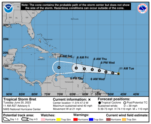
TROPICAL STORM BRET: The center of Tropical Storm Bret was located near latitude 11.9 North, longitude 47.0 West. Bret is moving toward the west near 21 mph, and this general motion is expected to continue for the next several days. On the forecast track, the center of Bret could move across portions of the Lesser Antilles Thursday afternoon through Thursday night. Maximum sustained winds are near 40 mph with higher gusts. Some strengthening is forecast during the next couple of days, and Bret is expected to be a tropical storm when it reaches the Lesser Antilles Thursday and Thursday night. The estimated minimum central pressure is 1008 mb (29.77 inches).
NEXT WEEK: For now, next week looks fairly routine for the final week of June across Alabama. Partly sunny days, hot and humid, with scattered, mainly afternoon and evening showers and storms. High will range from the upper 80s to perhaps mid 90s across the state.
BEACH FORECAST CENTER: Get the latest weather and rip current forecasts for the beaches from Fort Morgan to Panama City on our Beach Forecast Center page. There, you can select the forecast of the region that you are interested in visiting.
WORLD TEMPERATURE EXTREMES: Over the last 24 hours, the highest observation outside the U.S. was 119.7F at Zabol, Iran. The lowest observation was -81.2F Concordia, Antarctica.
CONTIGUOUS TEMPERATURE EXTREMES: Over the last 24 hours, the highest observation was 117F at Rio Grande Village, TX. The lowest observation was 25F at Evaro, MT.
Category: Alabama's Weather, ALL POSTS
About the Author (Author Profile)
Macon, Georgia Television Chief Meteorologist, Birmingham native, and long time Contributor on AlabamaWX. Stormchaser. I did not choose Weather, it chose Me. College Football Fanatic. @Ryan_StinnetSubscribe
If you enjoyed this article, subscribe to receive more just like it.


