Midday Nowcast: A Cloudy and Wet First Day of Summer
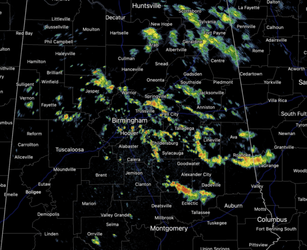
A cloudy and wet first day of summer across much of Alabama as the pesky upper low is sitting and spinning over Northern Georgia. Rain and storms are increasing in coverage as we head through the afternoon hours due to daytime heating causing higher instability. Rain and storms are moving northeast to southwest since we are on the western side of the low. Though organized severe storms are not expected, a few strong storms are possible, with gusty wind and small hail, but the overall severe weather threat remains very low. The main issues with storms will be tremendous amounts of lightning and torrential tropical downpours which could lead to isolated areas of flash flooding.
Due to the clouds and greater coverage of rain and storms, we are seeing below average temperatures with highs in the low to mid 80s. In fact, some locations are likely to stay in the 70s today. The forecast does not change much tomorrow, so keep the rain gear close as the radar will remain active.
SWELTERING TEXAS: An upper ridge centered over northern Mexico will continue to expand through the Central US over the next several days. The response will be a widespread and persistent record breaking heat wave across Texas. Air temperatures in the 100s and 110s and dewpoints in the 70s and 80s during the day followed by low temperatures in the 70s and 80s overnight will make for oppressive outdoor conditions over much of southern Texas. Excessive Heat Warnings and Heat Advisories are in effect for much of Texas and southern New Mexico. Repeated and lengthy exposure to heat can increase the risk of health impacts, including heat exhaustion and heat stroke.
FRIDAY AND THE WEEKEND: On Friday, the upper low pulls out of the region, decreasing our rain chances for Friday and the weekend. We will still have some afternoon showers and storms daily, but the coverage will be much less. Expect a partly sunny sky, hot and humid conditions as highs return to the lower 90s.
IN THE TROPICS: Invest 93-L: Satellite images indicate that the broad area of low pressure located about midway between the west coast of Africa and the Lesser Antilles has become better organized overnight. Environmental conditions appear conducive for further development of this system, and a tropical depression will likely form during the next couple of days. This system is expected to move westward to west-northwestward at 10 to 15 mph across the central tropical Atlantic through the early part of the weekend. Formation chance through 7 days…high…80 percent.
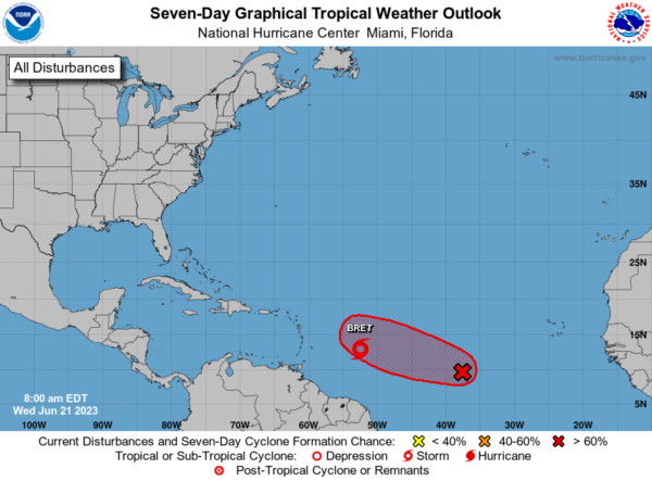
TROPICAL STORM BRET: The center of Tropical Storm Bret was located near latitude 13.0 North, longitude 52.5 West. Bret is moving toward the west near 14 mph, and this general motion with an increase in forward speed is expected during the next several days. On the forecast track, the center of Bret is expected to approach the Lesser Antilles on Thursday, move across the Lesser Antilles late Thursday and Thursday night, and then move westward across the eastern and central Caribbean Sea Friday and Saturday.
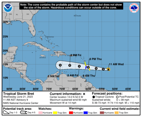
Maximum sustained winds are near 60 mph with higher gusts. Some increase in strength is forecast before Bret reaches the Lesser Antilles. Weakening is expected by Friday once Bret moves over the Caribbean Sea, and the system is likely to dissipate on Saturday. Tropical-storm-force winds extend outward up to 60 miles from the center. The estimated minimum central pressure is 1001 mb (29.56 inches).
NEXT WEEK: For now, next week looks fairly routine for the final week of June across Alabama. Partly sunny days, hot and humid, with scattered, mainly afternoon and evening showers and storms. High will range from the upper 80s to perhaps mid 90s across the state.
BEACH FORECAST CENTER: Get the latest weather and rip current forecasts for the beaches from Fort Morgan to Panama City on our Beach Forecast Center page. There, you can select the forecast of the region that you are interested in visiting.
WORLD TEMPERATURE EXTREMES: Over the last 24 hours, the highest observation outside the U.S. was 120.6F at Zabol, Iran. The lowest observation was -82.8F Amundsen-Scott South Pole Station, Antarctica.
CONTIGUOUS TEMPERATURE EXTREMES: Over the last 24 hours, the highest observation was 118F at Rio Grande Village, TX. The lowest observation was 22F at Crescent, OR.
Category: Alabama's Weather, ALL POSTS
About the Author (Author Profile)
Macon, Georgia Television Chief Meteorologist, Birmingham native, and long time Contributor on AlabamaWX. Stormchaser. I did not choose Weather, it chose Me. College Football Fanatic. @Ryan_StinnetSubscribe
If you enjoyed this article, subscribe to receive more just like it.


