Midday Nowcast: Watching the Radar
HEAT, HUMIDITY, DAILY STRONG STORMS: The forecast just doesn’t change much this time of year…for the next three days, expect a mix of sun and clouds with highs in the low 90s. The radar gets active during the afternoon and evening hours, with some strong storms possible and a few of them could become locally severe with strong, gusty winds and hail.
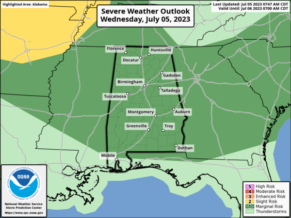
The SPC continues to have most of Alabama outlined in “marginal risk” (level 1/5) of severe thunderstorms this afternoon…BIG HEAT, BIG STORMS. The storms will be random and scattered, so it won’t rain everywhere and all summer storms produce tremendous amounts of lightning and heavy rainfall.
WEEKEND WEATHER & NEXT WEEK: More of the same with partly sunny, hot, humid weather Saturday and Sunday with the chance of random, scattered afternoon and evening storms. Chance of any one spot getting wet both days is 40-50 percent, highs will be in the low 90s for most communities. This pattern will persist into next week, but we continue to monitor forecast model output on whether the upper ridge across the Deep South could be bit stronger next week. If that is the case, heat levels will be rising, and coverage of afternoon storms dropping. Highs will be in the low to mid 90s.
IN THE TROPICS: All is quiet with no development expected the next seven days in the Gulf of Mexico, the Caribbean Sea, and across the Atlantic.
BEACH FORECAST CENTER: Get the latest weather and rip current forecasts for the beaches from Fort Morgan to Panama City on our Beach Forecast Center page. There, you can select the forecast of the region that you are interested in visiting.
CONTIGUOUS TEMPERATURE EXTREMES: Over the last 24 hours, the highest observation was 115F at Stovepipe Wells, CA. The lowest observation was 29F at Crescent, OR.
Category: Alabama's Weather, ALL POSTS
About the Author (Author Profile)
Macon, Georgia Television Chief Meteorologist, Birmingham native, and long time Contributor on AlabamaWX. Stormchaser. I did not choose Weather, it chose Me. College Football Fanatic. @Ryan_StinnetSubscribe
If you enjoyed this article, subscribe to receive more just like it.


