Midday Nowcast: Sunshine and Heat
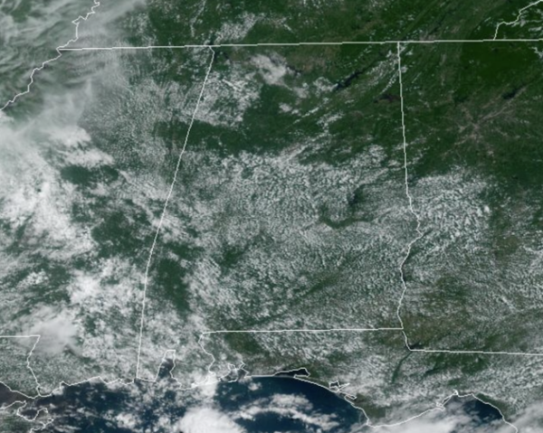
HOT AND MAINLY DRY DAYS: Today and tomorrow we stay generally stay dry over the northern 2/3 of the state. Moisture begins to return tomorrow, and a few scattered storms are possible mainly over the west-central counties. Heat levels will rise into low 90s this afternoon, with mid 90s in many places tomorrow.
ACROSS THE USA: Torrential rains across parts of New England will be slow to subside and dissipate and significant flooding remains possible. Flood watches will remain in effect for much of the region through varying times on Tuesday. Severe storms are possible the next few days from parts of the Plains into the Midwest. Dangerous heat across the Southern U.S. will gradually build and expand this week
THURSDAY/FRIDAY: These days we will mention scattered showers and thunderstorms statewide, mainly during the afternoon and evening hours. Highs will be in the 90°-95° range both days. Pretty routine weather for mid-July across Alabama.
WEEKEND AND BEYOND: Nothing unusual in the forecast and we will go with a classic summer weather for Alabama and most of the Deep South. Partly sunny days with scattered showers and thunderstorms, and afternoon highs will remain in the low to mid 90s. We note, that we could see some heat advisories issued across portions of the Deep South, including Alabama by the weekend as heat index values could approach the 105° danger range.
The only heat relief will come from those random, daily thunderstorms. Most of the activity will occur during the afternoon and evening hours, 2PM-10PM. Of course, summer storms producing gusty winds, torrential rainfall, and the most dangerous part of summer storms, tremendous amounts of lightning. Always remember if you can hear thunder, you can be struck by lightning, even if it is sunny and clear at your location, lightning can travel miles and miles outside of the parent thunderstorm…WHEN THUNDER ROARS, GO INDOORS!!!
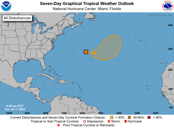
IN THE TROPICS: A trough of low pressure is producing disorganized showers and thunderstorms a few hundred miles east-northeast of Bermuda. Environmental conditions are forecast to be marginally conducive for gradual development of this system, and a subtropical or tropical depression could form on Thursday or Friday while the system moves generally eastward. By the weekend, the low should turn northward bringing the system over cooler waters, likely limiting additional development. Formation chance through 48 hours…low…30 percent. Formation chance through 7 days…medium…50 percent.
BEACH FORECAST CENTER: Get the latest weather and rip current forecasts for the beaches from Fort Morgan to Panama City on our Beach Forecast Center page. There, you can select the forecast of the region that you are interested in visiting.
WORLD TEMPERATURE EXTREMES: Over the last 24 hours, the highest observation outside the U.S. was 120.9F at Basrah-Hussen, Iraq. The lowest observation was -89.0F Dome A, Antarctica.
CONTIGUOUS TEMPERATURE EXTREMES: Over the last 24 hours, the highest observation was 113F at Death Valley, CA. The lowest observation was 31F at Loyalton, CA.
Category: Alabama's Weather, ALL POSTS
About the Author (Author Profile)
Macon, Georgia Television Chief Meteorologist, Birmingham native, and long time Contributor on AlabamaWX. Stormchaser. I did not choose Weather, it chose Me. College Football Fanatic. @Ryan_StinnetSubscribe
If you enjoyed this article, subscribe to receive more just like it.


