Midday Nowcast: Heat and Storms
HEAT AND STORMS: Classic mid-July weather across Alabama through the weekend. We will see scattered to numerous showers and storms each day, but also we will keep an eye on potential thunderstorm clusters riding around the edge of the ridge. Rain chances will be in the 50%-70% range for much of Alabama. Expect partly sunny days with highs in the low 90s. It won’t rain every where each day, but each day, the radar will be active with rain and storms.
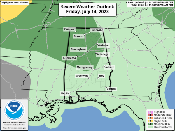
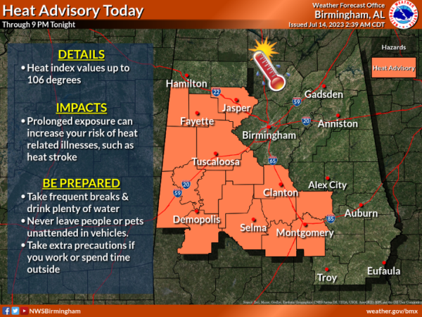
For today, the SPC has defined a “marginal risk” (level 1/5) of severe thunderstorms for about the northern 2/3 of the state this afternoon; heavier storms that form could produce strong winds. Along with the storm threat heat levels are an issue today, and likely at time over the next week. A “heat advisory” is in effect for parts of Central and West Alabama, where the heat index could touch 105° today.
NEXT WEEK: The ridge to the west will intensify and begin to expand east, meaning our temperatures will be climbing higher while rain chances will decrease and become more isolated. Mid to upper 90s are expected across Alabama and with high dew points, we are likely to see more heat alerts across Alabama as heat index values will likely exceed the 105° danger range. Be prepared!!!
IN THE TROPICS: We now have Don….At 1100 AM AST, the center of Subtropical Storm Don was located near latitude 33.7 North, longitude 47.3 West. Don is moving toward the north-northwest near 8 mph, and that general motion should continue through tonight. A turn toward the north is expected Saturday, followed by a turn toward the east by Sunday or Monday.
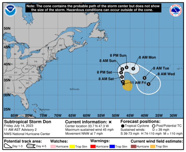
Recent satellite-derived wind data indicate that maximum sustained winds have decreased to near 45 mph with higher gusts. Additional gradual weakening is expected during the next few days, and Don could possibly become a post-tropical cyclone or remnant low at any time. Winds of 40 mph extend outward up to 205 miles from the center. The estimated minimum central pressure is 1004 mb (29.65 inches). The rest of the basin is quiet with no development expected through the next week.
BEACH FORECAST CENTER: Get the latest weather and rip current forecasts for the beaches from Fort Morgan to Panama City on our Beach Forecast Center page. There, you can select the forecast of the region that you are interested in visiting.
WORLD TEMPERATURE EXTREMES: Over the last 24 hours, the highest observation outside the U.S. was 123.4F at Ahwaz, Iran. The lowest observation was -101.4F Vostok, Antarctica.
CONTIGUOUS TEMPERATURE EXTREMES: Over the last 24 hours, the highest observation was 118F at Topock, AZ. The lowest observation was 32F at Mackay, ID.
Category: Alabama's Weather, ALL POSTS
About the Author (Author Profile)
Macon, Georgia Television Chief Meteorologist, Birmingham native, and long time Contributor on AlabamaWX. Stormchaser. I did not choose Weather, it chose Me. College Football Fanatic. @Ryan_StinnetSubscribe
If you enjoyed this article, subscribe to receive more just like it.


