Sunday Weather Briefing Video: More Hot Weather Ahead
The Alabama hot summer continues rolling along as we cruise through July. More highs in the 90s, more humidity, and more dangerously high heat indices. Let’s dig into the details.
FOR YOUR SUNDAY: A weak cold front, or something like one, slipped into Alabama overnight. It is the result of low pressure over the Upper Midwest that found a way to muscle slightly drier air into our state. But don’t look for any fall like temperatures anytime soon. We will be mostly dry today, with only the smallest chance of an isolated shower or storm, and highs between 90-94. Lows tonight will be in the upper 60s North and lower 70s South. I guess that is an improvement, right?
START TO THE WORK WEEK: Guidance says most of Monday will be dry and hot, although the highs in the middle 90s could trigger a few showers and storms during the afternoon and evening, especially as another shortwave passes to our north.
HEAT BUILDS: The ridge that has been baking the Southwest over to Texas will flex its muscles a bit over the Deep South, and pressures will build over Alabama by Tuesday. In fact, Tuesday, Wednesday, and Thursday look to be dry and hot. Highs each day will be in the middle and upper 90s, approaching 100 degrees in spots. Heat index values will be climbing as well, ranging from 94-100 Tuesday to 96-104 on Wednesday, and 97-105. This will all most likely trigger heat advisories across the area.
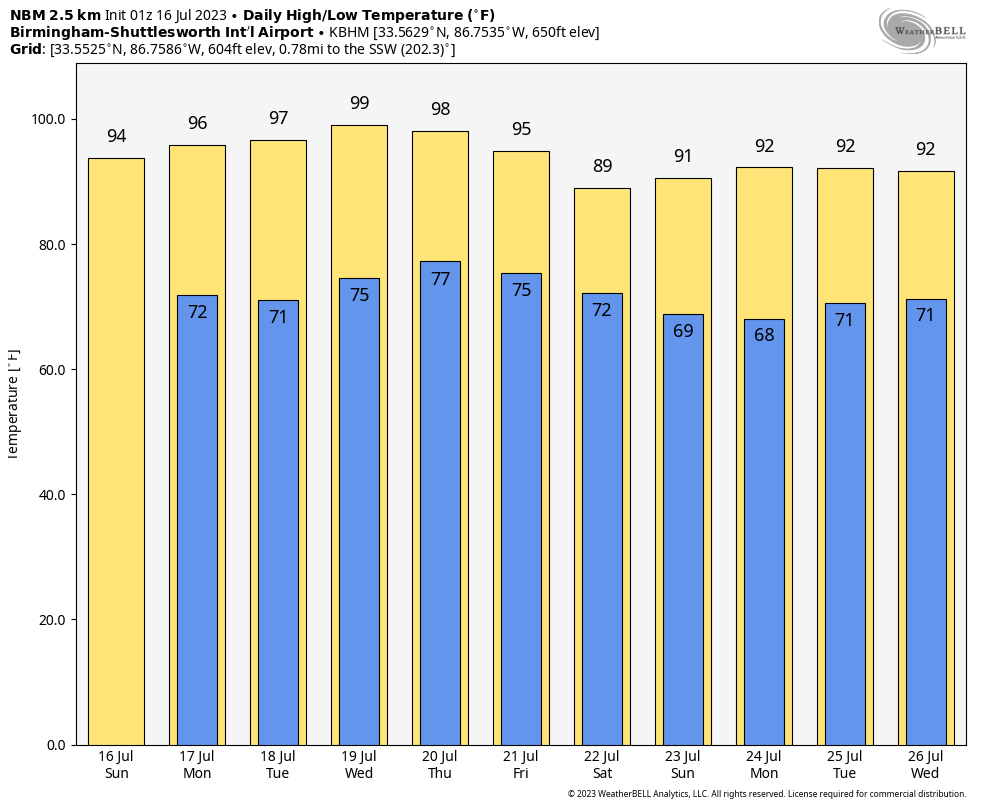
WEEKEND RESPITE: Looks like the eastern end of the ridge will begin to break down by Friday into the weekend, bringing back a chance of showers and storms and slightly cooler temperatures. Highs Friday, Saturday and Sunday will trend back into the 89-92 range, more normal for this time of year, with lows in the upper 60s to lower 80s.
WEEK TWO VOODOO: The ridge slowly builds back over Alabama and the Deep South, which means more heat and humidity for us. The ridge seems to finally have its back broken by the end of the month, which could spell some relief for the Southwest. But if that happens, we might really see our heat turning up.
BEACHCAST: Showers and thunderstorms will be likely through Tuesday before there is a break in the action from Wednesday through much of Friday. Storms become more common by Friday night through the weekend. The days won’t be total washouts, but there will be extended periods of rain and storms. Highs this week will be in the lower and middle 90s. Lows will be in the upper 70s. Water temperatures are in the lower 80s. The rip current risk is expected to be low except perhaps around storms.
Click here to see the Beach Forecast Center page.
IN THE TROPICS: Subtropical Storm Don is describing a large clockwise turn across the North Atlantic. It is about 900 miles east northeast of Bermuda. Top winds are only 40 mph, so it is barely hanging on since it has been moving northward over colder water. But as it continues to curve right, it will move over warmer waters, and could strengthen. Still, it is a long way from mattering to anything but shipping. Nothing else threatening to become a tropical cyclone over the next week to ten days. There is a strong tropical wave over the eastern Atlantic, but the models don’t do anything with it.
NATIONALLY: It’s heat vs. flooding in this epic American Weather Smackdown. Flood watches carpet the areas from northern Virginia to the Canadian Border in Maine. Meanwhile, heat advisories and excessive heat warnings extend from South Florida and South Alabama all the way to Washington State.
DANCING WITH THE STATS: 118F at Phoenix yesterday broke the record for the date, which was 117F set in 1998.
ADVERTISE WITH US: Deliver your message to a highly engaged audience by advertising on the AlabamaWX.com website. We have a lot of big plans for this year. Don’t miss out! We can customize a creative, flexible, and affordable package that will suit your organization’s needs. Contact me, Bill Murray, at (205) 687-0782 and let’s talk.
WEATHERBRAINS: This week, the panel will entertain the Beach Safety Chiefs from Gulf Shores and Orange Beach. The discussion will be about rip currents and the unacceptable death tolls that are being suffered along the Gulf Beaches. Check out the show at www.WeatherBrains.com. You can also subscribe on iTunes. You can watch the show live on our new YouTube channel for the show.You will be able to see the show on the James Spann 24×7 weather channel on cable or directly over the air on the dot 2 feed.
ON THIS DATE IN 1980: The death toll across the Alabama from an extended heat wave reached 77 and it was rising. Thirty seven of those fatalities were reported in Birmingham. The Magic City was in its 7th straight day of 100F+ degree heat. The high at the Birmingham Airport reached 105F, a record for the date. Other hot highs from the 16th included: 103F at Huntsville and 104F at Pinson; Jasper, Cullman and Scottsboro reached 105F. The string would extend one more day before being broken. At the National Weather Service Forecast Office in Birmingham, meteorologist Harold Quattlebaum said that the forecast was calling for the same thing for the next two days. Alabama Power Company was buying electricity from other utilities and hospitals across the state were running out of beds. Before it was all said and done, 120 Alabamians would perish from heat related maladies during the Heat Wave of 1980. Follow my weather history tweets on Twitter. I am @wxhistorian at Twitter.com.
Category: Alabama's Weather, ALL POSTS
About the Author (Author Profile)
Bill Murray is the President of The Weather Factory. He is the site's official weather historian and a weekend forecaster. He also anchors the site's severe weather coverage. Bill Murray is the proud holder of National Weather Association Digital Seal #0001 @wxhistorianSubscribe
If you enjoyed this article, subscribe to receive more just like it.


