Midday Nowcast: Heat and Storms
HEAT AND STORMS: Highs in the mid to upper 90s again today with a mix of sun and clouds. The sunshine remains filtered due to Canadian wildfire smoke in place across much of the eastern half of the U.S. Later this evening, we are likely to see an MCS (Mesoscale Convective System) drop into North Alabama and the SPC has defined a “marginal risk” (level 1/5) of severe thunderstorms for the northern third of the state…north of a line from Tuscaloosa, Pelham, and Wedowee.
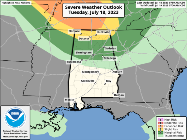
Portions of the Tennessee Valley are in the level 2 threat of severe storms. The main issue will come from damaging wind gusts.
ACROSS THE USA: The heat wave will continue in the Southwest, South Central U.S., and South Florida with record breaking heat is expected each day through midweek. Smoke from the Canadian wildfires will continue to bring poor air quality to parts of the Northern and Central U.S. into the East. Thunderstorms and heavy rains will be possible Tuesday across parts of the mid Mississippi/Lower-Missouri Valley.
REST OF THE WEEK: Hot and generally dry weather highlights the forecast for much of Alabama the rest of the week. Highs will remain in the mid to upper 90s and rain chances remain low, but not zero. By late Friday, but an approaching surface boundary will bring showers and storms into the state late in the day and into Friday night.
WEEKEND WEATHER: Showers and storms remain possible Saturday over the southern 2/3 of the state. Then, on Sunday, unusually dry air for summer will cover much of Alabama with a mostly sunny sky and lower humidity. Heat levels will decrease thus weekend with highs in the mid to upper 80s for much of North/Central Alabama. Any storms on Sunday should be confined to areas near the coast, and even there they should be pretty widely spaced.
NEXT WEEK: For now the week looks fairly quiet with mostly sunny days and only widely scattered afternoon showers or storms…highs will be in the low to mid 90s, which is pretty much what we expect in late July in Alabama.
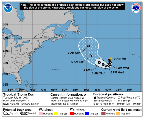
IN THE TROPICS: We still have Don in the Open Atlantic, which is no threat to the U.S. The rest of the basin is quiet and no development issues expected through the upcoming weekend.
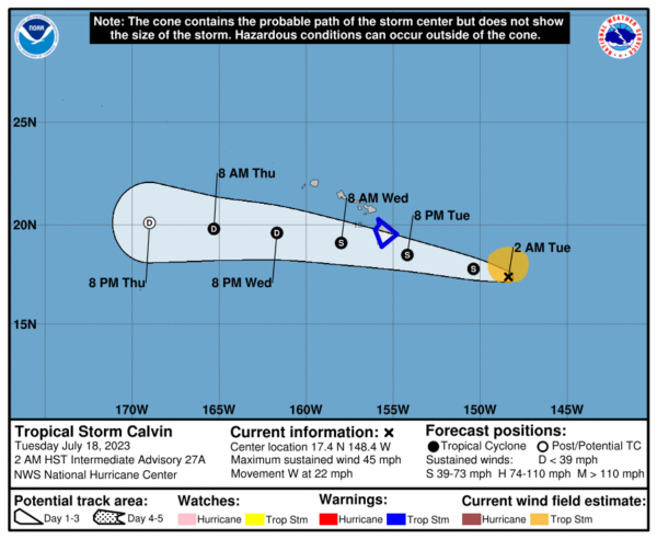
In the Central Pacific, Calvin continues to near Hawaii and it will pass very near the Big Island tomorrow night with tropical storm conditions.
BEACH FORECAST CENTER: Get the latest weather and rip current forecasts for the beaches from Fort Morgan to Panama City on our Beach Forecast Center page. There, you can select the forecast of the region that you are interested in visiting.
WORLD TEMPERATURE EXTREMES: Over the last 24 hours, the highest observation outside the U.S. was 122.0F at Basrah-Hussen, Iraq. The lowest observation was -98.0F Vostok, Antarctica.
CONTIGUOUS TEMPERATURE EXTREMES: Over the last 24 hours, the highest observation was 126F at Death Valley, CA. The lowest observation was 31F at Bynum, MT.
Category: Alabama's Weather, ALL POSTS
About the Author (Author Profile)
Macon, Georgia Television Chief Meteorologist, Birmingham native, and long time Contributor on AlabamaWX. Stormchaser. I did not choose Weather, it chose Me. College Football Fanatic. @Ryan_StinnetSubscribe
If you enjoyed this article, subscribe to receive more just like it.


