Severe Thunderstorm Watch for North Alabama
So far, the storms have been further north than expected, and it remains to be seen if that will change.
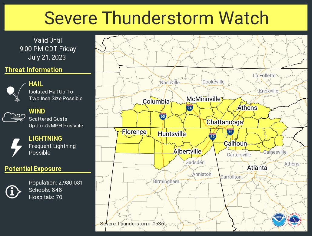
THE NATIONAL WEATHER SERVICE HAS ISSUED SEVERE THUNDERSTORM WATCH
536 IN EFFECT UNTIL 9 PM CDT THIS EVENING FOR THE FOLLOWING AREAS
IN ALABAMA THIS WATCH INCLUDES 11 COUNTIES
IN NORTH CENTRAL ALABAMA
CULLMAN LIMESTONE MADISON
MORGAN
IN NORTHEAST ALABAMA
DEKALB JACKSON MARSHALL
IN NORTHWEST ALABAMA
COLBERT FRANKLIN AL LAUDERDALE
LAWRENCE
IN TENNESSEE THIS WATCH INCLUDES 3 COUNTIES
IN SOUTHERN MIDDLE TENNESSEE
FRANKLIN TN LINCOLN MOORE
THIS INCLUDES THE CITIES OF ALBERTVILLE, ARAB, ATHENS, BOAZ,
COWAN, CULLMAN, DECATUR, DECHERD, ESTILL SPRINGS, FAYETTEVILLE,
FLORENCE, FORT PAYNE, GUNTERSVILLE, HUNTSVILLE, LYNCHBURG,
MOULTON, MUSCLE SHOALS, RAINSVILLE, RED BAY, RUSSELLVILLE,
SCOTTSBORO, SEWANEE, SHEFFIELD, TOWN CREEK, TUSCUMBIA,
AND WINCHESTER.
Category: Alabama's Weather, ALL POSTS, Severe Weather
About the Author (Author Profile)
Bill Murray is the President of The Weather Factory. He is the site's official weather historian and a weekend forecaster. He also anchors the site's severe weather coverage. Bill Murray is the proud holder of National Weather Association Digital Seal #0001 @wxhistorianSubscribe
If you enjoyed this article, subscribe to receive more just like it.


