Tuesday Weather Briefing — Not Terrible Today; Scattered Storms Return on Thursday
Monday’s Highs Across Central Alabama
97 – Troy
95 – Montgomery
94 – Anniston
93 – Shelby Co. Airport
93 – Tuscaloosa
92 – Birmingham
The First Day of August
Ridging will be off to our west which will continue a northerly to northwesterly flow across Central Alabama. While we look to stay dry throughout the day, we will see some clouds move into the area from an MCS that will be moving into Tennessee. Drier air in Alabama will keep any rain from falling from that approaching boundary. Skies will be partly to mostly sunny with highs ranging throughout the 90s.
Today is also known as…
• World Lung Cancer Day
• National Girlfriends Day
• National Planner Day
• National Night Out
• International Child-free Day
• World Wide Web Day
• National Alpaca Day
• Rounds Resounding Day
Hump Day Through Friday
We get back into a more typical late-summer pattern as on Wednesday we’ll see our flow transition from the northwest to out of the south and southwest, increasing humidity levels across the area. For now, heat index values will stay below advisory criteria, but the mugginess will be retuning. Only a few isolated storms are possible with highs in the upper 80s to the mid 90s.
An impulse looks to move into the area on Thursday that will fire off multiple scattered showers and storms mainly during the main heating of the day and into the evening, but don’t be surprised if one or two fire off during the morning. The coverage of rain and cloud cover will keep high temperatures in the mid 80s to the lower 90s. We’ll have to watch for a few strong storms along with heavy rainfall.
More scattered showers and storms can be expected during the afternoon to evening hours across Central Alabama on Friday, as rain chances remain higher. A few strong storms may develop with gusty winds. Highs in the upper 80s to the lower 90s.
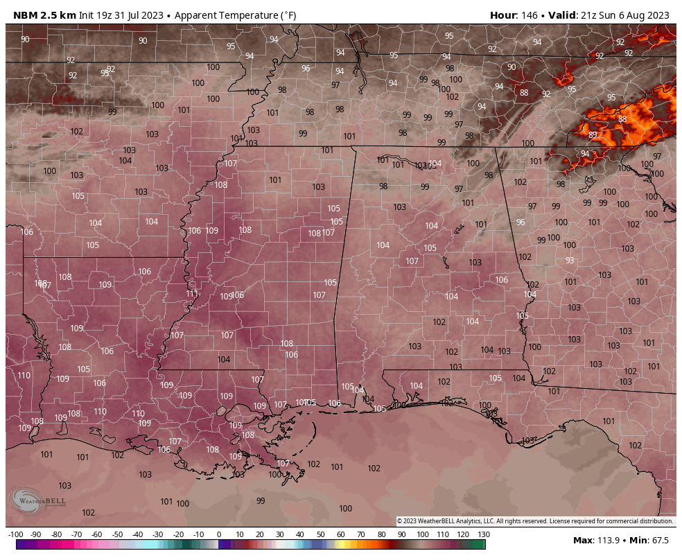
Projected “feels like” temperature at 4 pm Sunday afternoon.
The First Weekend of August 2023
Unfortunately, the heat returns in a big way as highs on both days will be throughout the 90s, and mix that with dewpoints in the mid to upper 70s, heat advisories will probably be issued as heat index values may reach as high as 110º. Our only saving grace is that scattered showers and storms will be possible, hopefully cooling some of us down during the afternoons. However, with this much heat and humidity in place, expect a few storms to be strong with gusty winds and dangerous cloud-to-ground lightning.
A Voodoo Land Peek Into Next Week
For now, it doesn’t look like the weather pattern for the second week of August will be much different than the first week. Scattered afternoon showers and storms will be possible on each afternoon to early evening. Highs on each day will range from the upper 80s to the mid 90s.
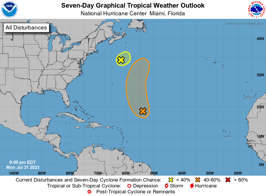
The Tropics (7pm Monday Evening Update)
Central Tropical Atlantic (Invest 96L): Showers and thunderstorms remain disorganized in association with a gale-force low pressure area located about 700 miles northeast of the northern Leeward Islands. Environmental conditions still could support tropical cyclone formation during the next few days while the system moves northwestward and then northward at 10 to 15 mph over the central subtropical Atlantic.
* Formation chance through 48 hours…medium…40 percent.
* Formation chance through 7 days…medium…50 percent.
Western Atlantic (Invest 97L): Shower and thunderstorm activity continues in association with a gale-force non-tropical low pressure system located over the western Atlantic several hundred miles south of Nova Scotia. The low is forecast to move quickly toward the east-northeast at 30 to 35 mph, reaching colder waters overnight. As a result, this system is unlikely to become a tropical storm.
* Formation chance through 48 hours…low…10 percent.
* Formation chance through 7 days…low…10 percent.
Category: Alabama's Weather, ALL POSTS, Tropical, Weather Xtreme Videos
About the Author (Author Profile)
Scott Martin is an operational meteorologist, professional graphic artist, musician, husband, and father. Not only is Scott a member of the National Weather Association, but he is also the Central Alabama Chapter of the NWA president. Scott is also the co-founder of Racecast Weather, which provides forecasts for many racing series across the USA. He also supplies forecasts for the BassMaster Elite Series events including the BassMaster Classic.Subscribe
If you enjoyed this article, subscribe to receive more just like it.


