Midday Nowcast: More Heat and More Storms Later Today
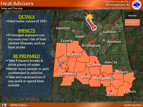
A heat advisory is in effect for portions of Central Alabama today and tomorrow as heat index values will again be over 105°, which is in the danger range. Big HEAT means Big STORMS, and more strong to severe storms will likely impact portions of North and Central Alabama later today and tonight as an MCS drops south out of Tennessee. It won’t rain everywhere, but where storms form they will be potentially strong to severe.
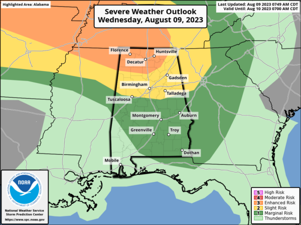
The SPC has defined an “enhanced risk” (level 3/5) of severe thunderstorms for the Tennessee Valley of the state, including Florence, the Shoals, Huntsville, Athens, Decatur, and as far south ass Cullman. A “slight risk” (level 2/5) extends as far south as Tuscaloosa, Calera, and Wedowee, and a “marginal risk” (level 1/5) covers much of the rest of South Alabama.
The general window for the heavier storms will come later today after 3PM, lasting through 11PM. Like recent days, the main concern will come from strong, possibly damaging straight line winds, in the 60-70 mph range. Of course all summer storms bring heavy rain and lots of lighting.
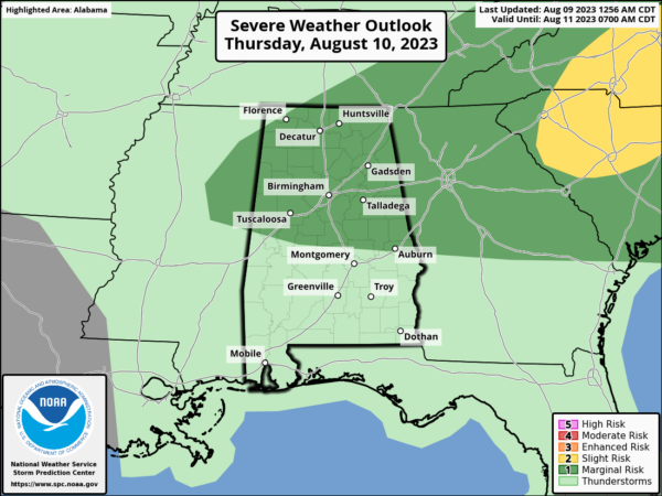
TOMORROW THROUGH THE WEEKEND: The overall pattern won’t change much. Each day we expect a mix of sun and clouds with the possibility of scattered showers and thunderstorms, most active during the afternoon and evening hours. The chance of any one spot getting wet daily is 45-55 percent, and highs will be in the low to mid 90s for most communities, and again heat alerts are likely to continue through the weekend as heat index values will likely be over 105°. We also not, the SPC the northern half of Alabama in the risk of severe weather again tomorrow.
NEXT WEEK: We see no reason the overall weather pattern will change much next week, so the persistence forecast will continue. It will be hot and humid with highs in the low to mid 90s…it is August in Alabama after all. Each day will feature those random, mainly afternoon and evening shower and storms, which will produce gusty winds and frequent lightning.
IN THE TROPICS: All is quiet and no tropical cyclone development is expected through the next seven days.
BEACH FORECAST CENTER: Get the latest weather and rip current forecasts for the beaches from Fort Morgan to Panama City on our Beach Forecast Center page. There, you can select the forecast of the region that you are interested in visiting.
WORLD TEMPERATURE EXTREMES: Over the last 24 hours, the highest observation outside the U.S. was 123.1F at Khanaqin, Iraq. The lowest observation was -112.0F Concordia, Antarctica.
CONTIGUOUS TEMPERATURE EXTREMES: Over the last 24 hours, the highest observation was 114F at Tecopa, CA. The lowest observation was 29F at Peter Sinks, UT.
Category: Alabama's Weather, ALL POSTS
About the Author (Author Profile)
Macon, Georgia Television Chief Meteorologist, Birmingham native, and long time Contributor on AlabamaWX. Stormchaser. I did not choose Weather, it chose Me. College Football Fanatic. @Ryan_StinnetSubscribe
If you enjoyed this article, subscribe to receive more just like it.


