Alabama Update Just After 1 a.m.
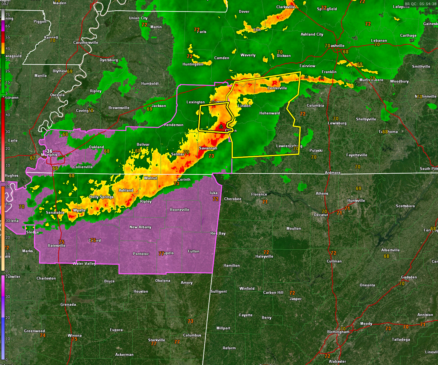
We are tracking a mesoscale convective complex that is moving across southern Tennessee with storms trailing into northern Mississippi.
Severe thunderstorm warnings are in effect for several counties south of I-40. Right now, just significant weather alerts in Mississippi.
I haven’t seen in any damage reports in the past hour.
The trailing storms are projected to reach Northwest Alabama around 1:30 a.m. and the Shoals area around 2 a.m. Cullman/Jasper around 3:30 a.m. Birmingham around 4:30-5 a.m.
The models do believe the storms will be packing a punch still as they push through Alabama, but I would have to believe the earlier convection has helped to stabilize the atmosphere quite a bit.
There is a tornado watch for northern Mississippi and southern Tennessee. A severe thunderstorm watch could be issued for North Alabama, but that is uncertain at this time.
LATE ADDITION
The SPC just issued a mesoscale discussion which put the probability of a watch being issued at 40%. here is the text of the MCD:
MESOSCALE DISCUSSION 1930
NWS STORM PREDICTION CENTER NORMAN OK
1259 AM CDT THU AUG 10 2023
AREAS AFFECTED…SOUTHERN MIDDLE TN INTO NORTH AL
CONCERNING…SEVERE POTENTIAL…WATCH POSSIBLE
VALID 100559Z – 100730Z
PROBABILITY OF WATCH ISSUANCE…40 PERCENT
SUMMARY…SOME DAMAGING-WIND THREAT WILL PERSIST OVERNIGHT AS STORMS
SPREAD EASTWARD. DOWNSTREAM WATCH ISSUANCE IS POSSIBLE IF THERE IS
ANY UPTICK IN STORM INTENSITY/ORGANIZATION.
DISCUSSION…A SMALL BOWING SEGMENT HAS EVOLVED WITHIN A LARGER
THUNDERSTORM CLUSTER ACROSS WESTERN TN. THE DOWNSTREAM ENVIRONMENT
REMAINS FAVORABLE FOR ORGANIZED CONVECTION, WITH RATHER STRONG
LOW/MIDLEVEL FLOW AND FAVORABLE DEEP-LAYER SHEAR NOTED ON REGIONAL
VWPS, ALONG WITH MODERATE BUOYANCY. A LOW-LEVEL TEMPERATURE
INVERSION AND A RELATED TENDENCY FOR CONVECTION TO BE SOMEWHAT
ELEVATED HAS LIMITED THE DAMAGING-WIND THREAT THUS FAR, AND MAY
CONTINUE TO DO SO AS STORMS GENERALLY STAY NORTH OF AN OUTFLOW
BOUNDARY ACROSS CENTRAL AL. HOWEVER, ANY UPTICK IN INTENSITY WITH
THE BOWING SEGMENT AND/OR THE TRAILING CONVECTION TO THE SOUTHWEST
MAY BE ACCOMPANIED BY AN INCREASING RISK FOR DAMAGING GUSTS
OVERNIGHT. SHORT-TERM TRENDS WILL CONTINUE TO BE MONITORED FOR
POSSIBLE WATCH ISSUANCE.
..DEAN/GRAMS.. 08/10/2023
Category: Alabama's Weather, ALL POSTS, Severe Weather
About the Author (Author Profile)
Bill Murray is the President of The Weather Factory. He is the site's official weather historian and a weekend forecaster. He also anchors the site's severe weather coverage. Bill Murray is the proud holder of National Weather Association Digital Seal #0001 @wxhistorianSubscribe
If you enjoyed this article, subscribe to receive more just like it.


