Midday Nowcast: Hot, Hot, Hot
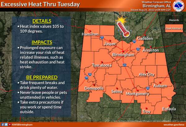
THE HEAT DOME: A strong upper high covers much of the eastern 2/3 of the U.S. and will keep Alabama’s weather mostly dry and very hot all week. We have had dangerous heat levels lately, but that was due to heat index values being so high. This week, it will not be as humid, but the actual air temperatures will be very hot, and likely the hottest actual air temperature of 2023 for most of Alabama. Highs this week, across Alabama will be in the mid to upper 90s, and some locations will see low 100s. Heat index value values will be in the 105°-109° range, and heat advisories are in effect once again.
Rain chances are near zero most of the week due to the sinking air under the upper high. The days will be mostly sunny, with fair nights. An isolated storm could pop up somewhere across South Alabama on a day or two, but most of the state will stay dry through the week.
WEEKEND WEATHER: The weather won’t change much Saturday with very hot and mainly dry conditions, but heat levels are expected to drop Sunday as the upper ridge weakens and shifts to the west. Sunday’s high will be in the low 90s, and a few afternoon showers or storms could pop up thanks to the cooler air aloft. Rolling into the final week of August, highs look to drop into the upper 80s
through the first half of the week, and we will mention a chance of scattered showers and storms daily.
IN THE TROPICS: Sometimes, things that spin get names, and that’s why we have Emily and Gert. These two systems are junk systems, and will dissipate soon with no impacts on anything.
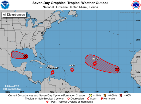
Franklin is moving toward the west near 12 mph. A westward to west-northwestward track is expected to continue today. A sharp turn to the north is expected tonight or early Tuesday, and a generally northward motion is expected on Tuesday. On the forecast track, the center of Franklin is forecast to reach the southern coast of Hispaniola late Tuesday or Tuesday night. Maximum sustained winds are near 50 mph, and some strengthening is forecast before Franklin reaches Hispaniola. The estimated minimum central pressure is 999 mb (29.50 inches). The system will move back into the South Atlantic and is expected to become a hurricane late this week.
In the western Gulf, Invest 91L: Showers and thunderstorms are showing signs of organization in association with a broad area of low pressure located over the central Gulf of Mexico. Environmental conditions appear conducive for development of this system, and a tropical depression or tropical storm is likely to form before it reaches the western Gulf of Mexico coastline on Tuesday. Interests in southern Texas and northern Mexico should monitor the progress of this system as tropical storm watches or warnings are likely to be issued later today. Formation chance: high…80 percent.
Way out in the Eastern Atlantic, Invest 92L: Showers and thunderstorms over the Cabo Verde Islands and portions of the tropical eastern Atlantic are associated with a tropical wave. Environmental conditions appear generally conducive for gradual development of this system, and a tropical depression is likely to form later this week while it moves west-northwestward across the eastern tropical Atlantic. Formation chance through 48 hours…medium…40 percent. Formation chance through 7 days…high…70 percent.
Next several names: Harold, Idalia, Jose, and Katia.
Finally, out west, Hilary has become post-tropical, but continues to dump heavy rainfall across the western states.
BEACH FORECAST CENTER: Get the latest weather and rip current forecasts for the beaches from Fort Morgan to Panama City on our Beach Forecast Center page. There, you can select the forecast of the region that you are interested in visiting.
WORLD TEMPERATURE EXTREMES: Over the last 24 hours, the highest observation outside the U.S. was 121.3F at Nasiriya, Iraq. The lowest observation was -105.5F Concordia, Antarctica.
CONTIGUOUS TEMPERATURE EXTREMES: Over the last 24 hours, the highest observation was 113F at Comanche, TX. The lowest observation was 37F at Walden, CO.
Category: Alabama's Weather, ALL POSTS
About the Author (Author Profile)
Macon, Georgia Television Chief Meteorologist, Birmingham native, and long time Contributor on AlabamaWX. Stormchaser. I did not choose Weather, it chose Me. College Football Fanatic. @Ryan_StinnetSubscribe
If you enjoyed this article, subscribe to receive more just like it.


