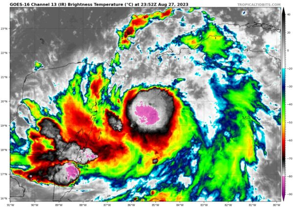
Idalia is Starting to Strengthen a Little This Evening
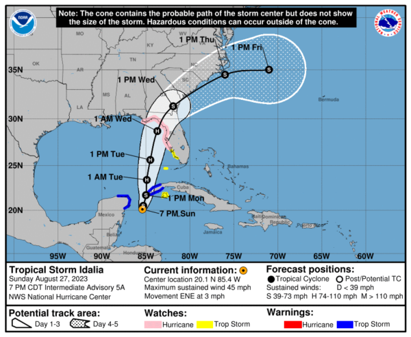
SUMMARY OF 700 PM CDT…0000 UTC…INFORMATION
———————————————-
LOCATION…20.1N 85.4W
ABOUT 100 MI…165 KM ESE OF COZUMEL MEXICO
MAXIMUM SUSTAINED WINDS…45 MPH…75 KM/H
PRESENT MOVEMENT…ENE OR 70 DEGREES AT 3 MPH…6 KM/H
MINIMUM CENTRAL PRESSURE…995 MB…29.39 INCHES
WATCHES AND WARNINGS
——————–
A Tropical Storm Warning is in effect for…
* Yucatán Peninsula from Tulum to Rio Lagartos, including Cozumel
* Pinar del Rio Cuba
A Storm Surge Watch is in effect for…
* Chokoloskee to Indian Pass Florida, including Tampa Bay
A Hurricane Watch is in effect for…
* Englewood to Indian Pass Florida, including Tampa Bay
A Tropical Storm Watch is in effect for…
* Isle of Youth Cuba
* South of Englewood to Chokoloskee Florida
* Dry Tortugas Florida
DISCUSSION AND OUTLOOK
———————-
At 700 PM CDT (0000 UTC), the center of Tropical Storm Idalia was located near latitude 20.1 North, longitude 85.4 West. Idalia is moving toward the east-northeast near 3 mph (6 km/h). A slow, possibly erratic, motion is expected overnight. A generally northward to north-northeastward motion at an increasing forward speed is expected on Monday and Tuesday. On the forecast track, the center will move over the eastern Gulf of Mexico on Monday and Tuesday, and approach the northeastern Gulf coast late Tuesday.
Buoy observations indicate that Idalia’s maximum sustained winds have increased to near 45 mph (75 km/h) with higher gusts. Additional strengthening is forecast, and Idalia is expected to become a hurricane over the southeastern Gulf of Mexico by early Tuesday. Additional strengthening is likely while Idalia approaches the northeastern Gulf coast.
Tropical-storm-force winds extend outward up to 70 miles (110 km) from the center. NOAA buoy 42056 over the far northwestern Caribbean Sea recently reported a sustained wind of 42 mph (68 km/h) and a wind gust to 49 mph (79 km/h). The estimated minimum central pressure is 995 mb (29.39 inches).
KEY MESSAGES
————
1. Idalia is forecast to become a hurricane over the eastern Gulf of Mexico, and there is an increasing risk of life-threatening storm surge and hurricane-force winds along portions of the west coast of Florida and the Florida Panhandle beginning as early as Tuesday. Although it is too soon to specify the exact location and magnitude of these impacts, residents in these areas should monitor updates to the forecast and follow any advice given by local officials. Storm surge and hurricane watches have been issued for portions of the west coast of Florida and the coast of the Florida Panhandle, and residents in these areas should monitor updates to the forecast and follow any advice given by local officials.
2. Scattered flash and urban flooding can be expected across portions of the west coast of Florida, the Florida Panhandle and portions of the Southeast U.S. by Tuesday into Thursday. Flooding from heavy rainfall is likely over portions of the southeast U.S. by mid to late week.
3. Heavy rainfall from Tropical Storm Idalia is expected across portions of the eastern Yucatán and western Cuba and may produce areas of flash and urban flooding as well as landslides across western Cuba.
4. Tropical storm conditions are expected over portions of the Yucatán Peninsula and extreme western Cuba with tropical storm conditions possible on the Isle of Youth.
Category: Alabama's Weather, ALL POSTS, Tropical


