Heat Levels Down; Rain Chances Up
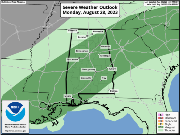
RADAR CHECK: A number of showers and storms are in progress across Alabama early this morning.. .a sign the upper ridge continues weaken over the region. This will lead to lower heat levels today along with higher rain chances. We note SPC has much of Alabama in a “marginal risk” (level 1/5) of severe thunderstorms today…
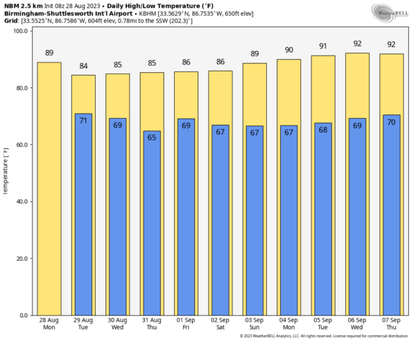
Storms this afternoon and early tonight will have potential for microbursts, small scale areas of damaging straight line winds. Highs today will range from the upper 80s over North Alabama to the low to mid 90s over the southern counties of the state.
REST OF THE WEEK: We expect scattered to numerous showers and thunderstorms tomorrow; the sky will be cloudy at times with a high in the 84-91 degree range. Then, on Wednesday, the best chance of rain will over the southeast part of the state (mainly from Montgomery south and east) as Hurricane Idalia passes through North Florida and South Georgia. Thursday and Friday will be dry with lower humidity and cooler nights; highs will be in the 80s for North Alabama, with low 90s to the south.
LABOR DAY WEEKEND: Most of Alabama will be dry… expect mostly sunny days and fair nights with highs in the upper 80s and low 90s for most communities. We can’t rule out a few isolated showers Saturday over the far southern part of the state, but even there most places will be dry.
NEXT WEEK: The upper ridge begins to rebuild; highs will be in the 90-95 degree range with only isolated afternoon showers or storms around. See the video briefing for maps, graphics, and more details.
MONDAY MORNING NOTES ON IDALIA: Tropical Storm Idalia early this morning is about 125 miles south of the western tip of Cuba with winds of 65 mph. It is expected to become a hurricane later today.
*A hurricane watch remains in effect for the Florida coast from Indian Pass to Englewood, including Tampa Bay.
*No change in the forecast track; the official NHC forecast brings the hurricane into the Florida “Big Bend” region north of Tampa Bay early Wednesday morning.
*Over the Gulf of Mexico, the environment is forecast to become conducive for significant strengthening of Idalia due to a new trough dropping south over the western Gulf of Mexico as a upper-level ridge builds near the system. Additionally, Idalia will be moving over waters in the upper 80s, and some of the guidance is even indicating favorable jet dynamics on Wednesday with Idalia in the right-rear quadrant of the jet over the southeastern U.S.
*The bottom line is that rapid intensification is becoming increasingly likely before landfall, and the NHC forecast now explicitly indicates it between 24-48 h in the forecast. Idalia is expected to be a major, category three hurricane at the time of landfall..
*The risk continues to increase for life-threatening storm surge and dangerous hurricane-force winds along portions of the west coast of Florida beginning as early as late tomorrow.
*Remember, the main impact from wind, rain, storm surge, flooding, and isolated tornadoes will be along and to the right (south down the west coast of the Florida Peninsula) of the circulation center.
*Idalia will bring lots of rain and wind to cities like Orlando and Jacksonville during the day Wednesday.
*The Alabama Gulf Coast and the western part of the Florida Panhandle won’t have much direct impact from Idalia in terms of weather, but dangerous rip currents are likely tomorrow and Wednesday. The hurricane watch does not include places like Panama City, Destin, or points west.
*Alabama will be on the dry side of the system, but a few showers and breezy conditions are likely over the southeast counties of the state Wednesday.
FRANKLIN: The other tropical system on the board this morning is Hurricane Franklin, a major hurricane with winds of 115 mph about 500 miles southwest of Bermuda. Franklin will pass west of Bermuda Wednesday, then it heads out to sea. No impact to the U.S.
ON THIS DATE IN 1990: Between 3:15 p.m. and 3:45 p.m. a devastating F5 tornado ripped a 16.4 mile-long path through portions of Kendall and Will counties in northern Illinois. A total of 29 people were killed, and 350 more were injured.
Look for the next video briefing here by 3:00 this afternoon… enjoy the day!
Category: Alabama's Weather, ALL POSTS, Weather Xtreme Videos


