10 a.m. Look at Idalia: Hurricane is Intensifying
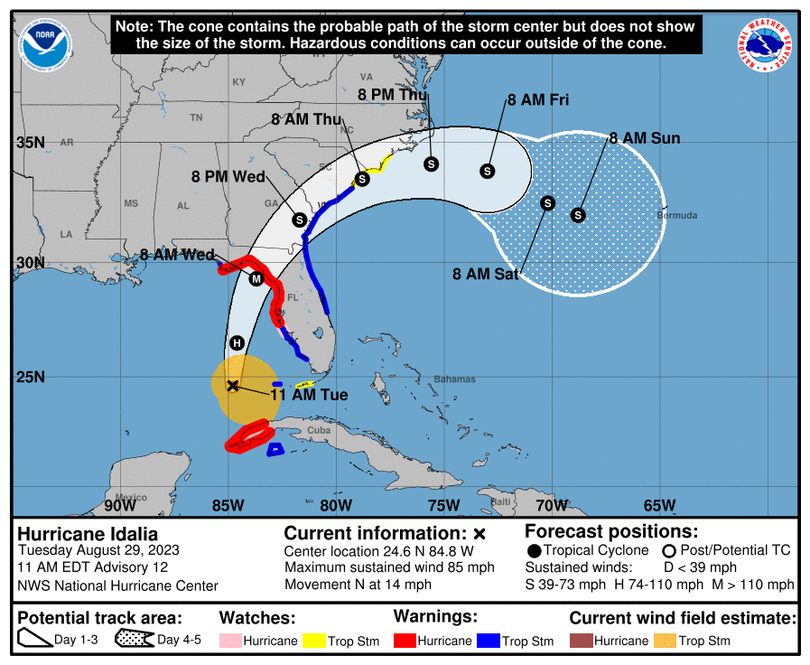
Idalia became better organized overnight and became a hurricane. That trend continues this morning and rapid intensification is expected today and tonight before a Wednesday morning landfall.
The NHC expects Hurricane Idalia to rapidly intensify over warm Gulf waters into a dangerous major hurricane before landfall on Wednesday.
There will be life-threatening storm surge in Florida’s Big Bend and Nature Coast area early Wednesday. Surge could reach 8-12 feet in the area near and east of the landfall somewhere between the Ancilla RIver and Chassahowitzka, FL. Storm surge flooding will be extensive on the west coast of Florida. Consult latest surge maps and evacuation instructions from the National Hurricane Center and local officials.
Top winds are now 85 mph. The central pressure according to the Hurricane Hunters is now 976 mb.
Movement is north at 14 mph. On the Hurricane Center track, it will make landfall early Wednesday morning along Florida’s Big Bend of Nature Coast, near or just west of Cedar Key.
There will be life-threatening storm surge in Florida’s Big Bend and Nature Coast area early Wednesday. Surge could reach 8-12 feet in the area near and east of the landfall somewhere between the Ancilla RIver and Chassahowitzka, FL. Storm surge flooding will be extensive on the west coast of Florida. Consult latest surge maps and evacuation instructions from the National Hurricane Center and local officials.
Tropical storm force winds will begin to spread along the West Coast of Florida as early as late this afternoon. Here is the most likely timetable:
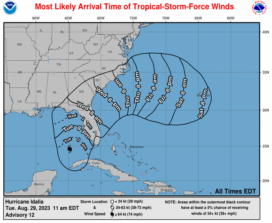
Strong tropical storm force winds 58 mph or greater will reach the coast after midnight tonight with hurricane force winds reaching the coast during the early morning hours.
The model guidance is all in good agreement on track and intensity. Some of it forecasts Idalia to reach 110-120 knots or 125-140 mph before landfall and the hurricane center forecast shows 110 knots/125 mph just before landfall Wednesday morning.
About the Author (Author Profile)
Bill Murray is the President of The Weather Factory. He is the site's official weather historian and a weekend forecaster. He also anchors the site's severe weather coverage. Bill Murray is the proud holder of National Weather Association Digital Seal #0001 @wxhistorianSubscribe
If you enjoyed this article, subscribe to receive more just like it.


