Hurricane Center Raises Max Surge Forecast
The new forecast package from the Hurricane Center is calling for a strong Category 3 125 mph hurricane at landfall with Idalia.
That means residents and emergency managers have to prepare for a Category 4 hurricane which it could easily become.
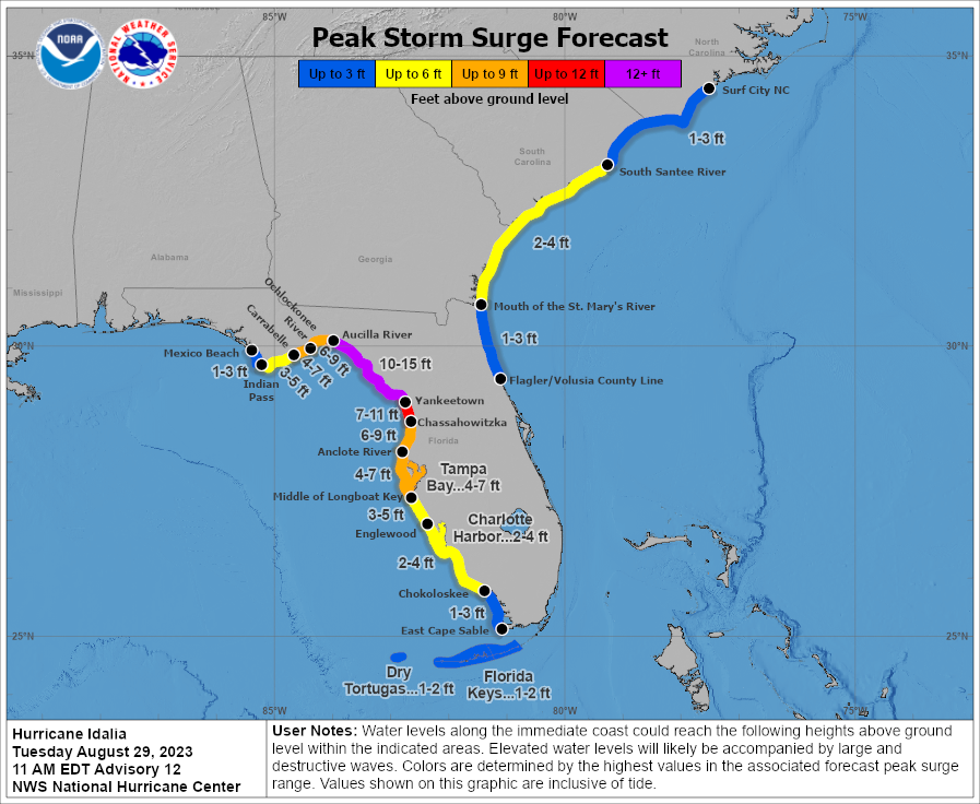
The NHC has raised the max surge values near and to the right of the landfall point. Here are the latest forecasts:
Aucilla River, FL to Yankeetown, FL…10-15 ft
Yankeetown to Chassahowitzka, FL…7-11 ft
Chassahowitzka, FL to Anclote River, FL…6-9 ft
Ochlockonee River, FL to Aucilla River, FL…6-9 ft
Anclote River, FL to Middle of Longboat Key, FL…4-7 ft
Tampa Bay…4-7 ft
Carrabelle, FL to Ochlockonee River, FL…4-7 ft
Middle of Longboat Key, FL to Englewood, FL…3-5 ft
Englewood, FL to Chokoloskee, FL…2-4 ft
Charlotte Harbor…2-4 ft
Indian Pass, FL to Carrabelle, FL…3-5 ft
Mouth of the St. Mary’s River to South Santee, SC…2-4 ft
South Santee, SC to Surf City, NC…1-3 ft
Chokoloskee, FL to East Cape Sable, FL…1-3 ft
Flagler/Volusia County Line, FL to Mouth of St. Mary’s River…1-3
ft
Indian Pass to Mexico Beach…1 to 3 ft.
Florida Keys…1-2 ft
Yankeetown Florida is famous for an amazing rainfall record observed during 1950’s Hurricane Easy. 38.70 inches of rain was recorded in just 24 hours there to set the Florida state record.
About the Author (Author Profile)
Bill Murray is the President of The Weather Factory. He is the site's official weather historian and a weekend forecaster. He also anchors the site's severe weather coverage. Bill Murray is the proud holder of National Weather Association Digital Seal #0001 @wxhistorianSubscribe
If you enjoyed this article, subscribe to receive more just like it.


