Midday Nowcast: Air You Can Wear; Idalia Strengthening
A very muggy air mass is in place across Alabama today, and that will fuel afternoon and evening showers and storms to form again today. The chance of any one spot getting wet today is 40-50%, and like yesterday the storms will be very efficient rain producers and will likely produce areas of isolated flash flooding. When it is not rain, we are seeing a mix of sun and clouds, with highs in the mid to upper 80s over the northern counties, with low 90s to the south.
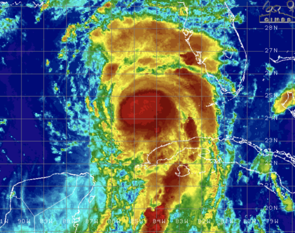
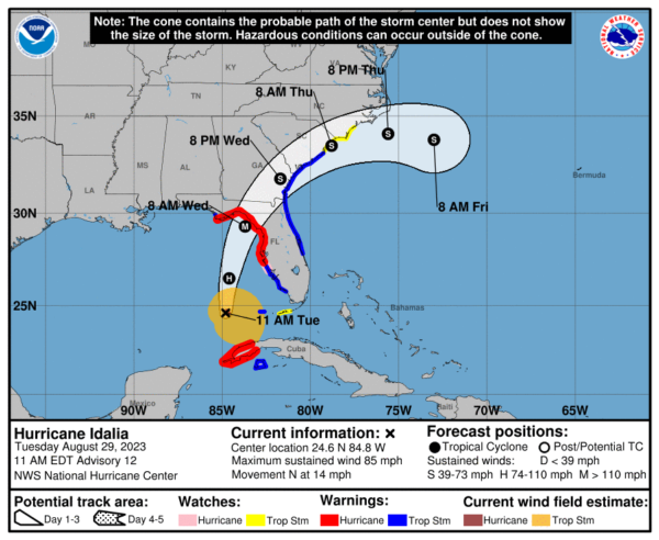
HURRICANE IDALIA: Late morning update, Idalia is strengthening…The center of Hurricane Idalia was located near latitude 24.5 North, longitude 84.8 West. Idalia is moving toward the north near 14 mph. A faster motion toward the north and north-northeast is expected through early Wednesday while Idalia approaches the Gulf coast of Florida. A turn toward the northeast and east-northeast is forecast late Wednesday and Thursday, bringing the center of Idalia near or along the coasts of Georgia and the Carolinas.
Maximum sustained winds have increased to near 85 mph with higher gusts. Rapid intensification is expected before landfall, and Idalia is forecast to be a major hurricane when it reaches the Gulf coast of Florida Wednesday morning. Hurricane-force winds extend outward up to 15 miles from the center and tropical-storm-force winds extend outward up to 160 miles. The estimated minimum central pressure from NOAA Hurricane Hunter aircraft data is 976 mb (28.82 inches).
The risk continues to increase for life-threatening storm surge and dangerous hurricane-force winds along portions of the west coast of Florida beginning as early as late tomorrow. This threat will spread through Northern Florida, and then South and Southeast Georgia tomorrow.
Remember, the main impact from wind, rain, storm surge, flooding, and isolated tornadoes will be along and to the right (south down the west coast of the Florida Peninsula) of the circulation center.
The Alabama Gulf Coast and the western part of the Florida Panhandle won’t have much direct impact from Idalia in terms of weather, but dangerous rip currents are likely today and tomorrow. Alabama will be on the dry side of the system.
REST OF THE WEEK: The best chance of rain across Alabama tomorrow will be over the southeast counties of the state as Idalia passes to the east. Windy and showery conditions are likely from Eufaula to Dothan, but the significant impact of the hurricane will be well to the east. For the rest of the state, expect a mix of sun and clouds with highs in the 80s over North Alabama, with low 90s over the southern counties. On the back side of the system, drier air gets pulled down into the state and Thursday and Friday will be dry with sunny days, lower humidity, and cooler nights. Some of the cooler spots across North Alabama will dip into the 50s early Thursday morning. Highs will stay in the mid to upper 80s over the northern counties, with low 90s to the south.
LABOR DAY WEEKEND: Most of Alabama will be dry… expect mostly sunny days and fair nights with highs in the upper 80s, lows in the 60s. We can’t rule out a few isolated showers Saturday over the far southern part of the state, but even there most places will be dry. Humidity levels will not be bad this weekend, and overall, a fairly nice Labor Day Weekend for much of Alabama.
FOOTBALL WEATHER: College football ramps up this weekend. Thankfully the weather will be very quiet across the Deep South.
UAB’s opener is Thursday against North Carolina AT&T at Protective Stadium in downtown Birmingham (7:00p CT kickoff). The sky will be clear with temperatures falling from 84 at kickoff, into the 70s during the second half.
Auburn will host UMass Saturday afternoon at Jordan-Hare Stadium (2:30p CT kickoff)… the sky will be sunny with a kickoff temperature near 89 degrees, falling into the mid 80s by the final whistle.
And, Saturday evening Alabama hosts Middle Tennessee State at Bryant-Denny Stadium (6:30p CT kickoff). The sky will be clear with temperatures falling from near 90 degrees at kickoff, into the upper 70s by the end of the game.
INTO NEXT WEEK: The upper ridge begins to rebuild; highs will be in the 90-95 degree range with only isolated afternoon showers or storms around.
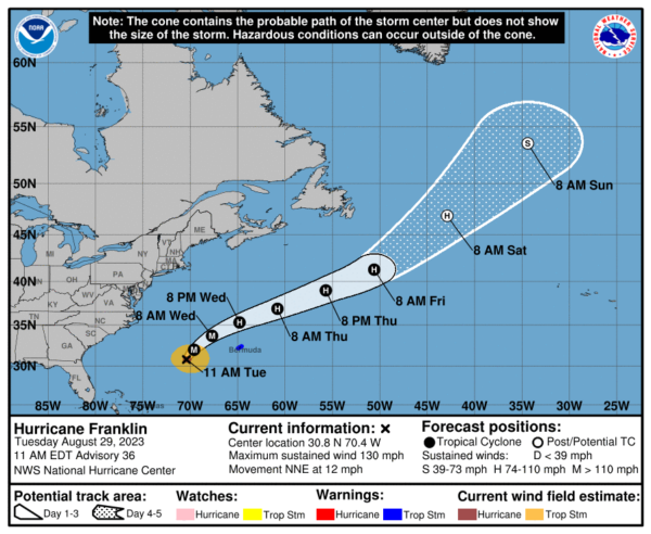
HURRICANE FRANKLIN: Franklin remains a category 4 hurricane. The center of Hurricane Franklin was located near latitude 30.8 North, longitude 70.4 West. Franklin is moving toward the north-northeast near 12 mph. A north-northeastward to northeastward motion with a faster forward speed is expected during the next few days. On the forecast track, the center of Franklin is expected to pass to the northwest of Bermuda on Wednesday.
Maximum sustained winds are near 130 mph with higher gusts. Steady weakening is forecast during the next several days, but Franklin will remain a hurricane through late this week. Hurricane-force winds extend outward up to 35 miles from the center and tropical-storm-force winds extend outward up to 150 miles. The estimated minimum central pressure is 941 mb (27.79 inches).
BEACH FORECAST CENTER: Get the latest weather and rip current forecasts for the beaches from Fort Morgan to Panama City on our Beach Forecast Center page. There, you can select the forecast of the region that you are interested in visiting.
WORLD TEMPERATURE EXTREMES: Over the last 24 hours, the highest observation outside the U.S. was 117.7F at Basrah-Hussen, Iraq. The lowest observation was -100.5F Vostok, Antarctica.
CONTIGUOUS TEMPERATURE EXTREMES: Over the last 24 hours, the highest observation was 120F at Winterhaven, CA. The lowest observation was 32F at Peter Sinks, UT.
Category: Alabama's Weather, ALL POSTS


