Busy Day in the Tropical Atlantic
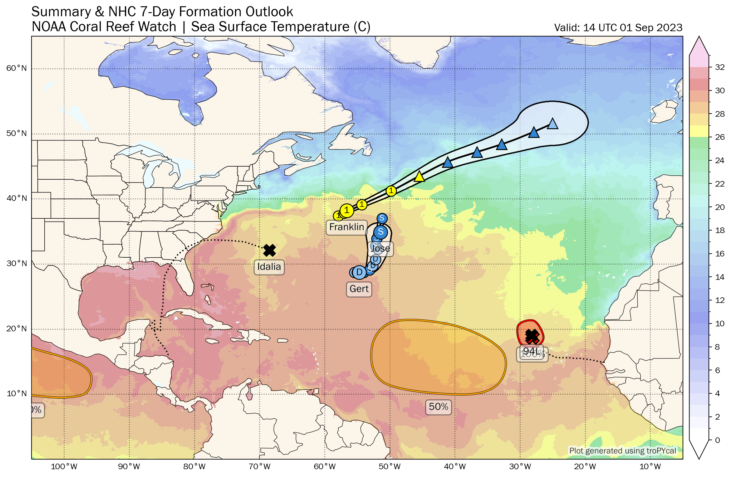
Tropical Depression 11 has formed in the far eastern Atlantic. It is expected to become Tropical Storm Katia.
BULLETIN
Tropical Depression Twelve Advisory Number 1
NWS National Hurricane Center Miami FL AL122023
200 PM CVT Fri Sep 01 2023
…TROPICAL DEPRESSION FORMS OVER THE EASTERN ATLANTIC…
SUMMARY OF 200 PM CVT…1500 UTC…INFORMATION
———————————————-
LOCATION…19.6N 28.3W
ABOUT 375 MI…605 KM NW OF THE CABO VERDE ISLANDS
MAXIMUM SUSTAINED WINDS…35 MPH…55 KM/H
PRESENT MOVEMENT…NNW OR 340 DEGREES AT 8 MPH…13 KM/H
MINIMUM CENTRAL PRESSURE…1007 MB…29.74 INCHES
WATCHES AND WARNINGS
——————–
There are no coastal watches or warnings in effect.
DISCUSSION AND OUTLOOK
———————-
At 200 PM CVT (1500 UTC), the center of Tropical Depression Twelve
was located near latitude 19.6 North, longitude 28.3 West. The
depression is moving toward the north-northwest near 8 mph (13
km/h). A motion toward the north-northwest and northwest at a
faster forward speed is expected through Sunday. A turn toward the
west-northwest is forecast later on Sunday.
Maximum sustained winds are near 35 mph (55 km/h) with higher gusts.
Some strengthening is expected, and the depression is forecast to
become a tropical storm later today or this evening. The system is
likely to weaken early Sunday and degenerate to a remnant low by
late Sunday.
The estimated minimum central pressure is 1007 mb (29.74 inches).
HAZARDS AFFECTING LAND
———————-
None
NEXT ADVISORY
————-
Next complete advisory at 800 PM CVT.
Forecaster Berg
Tropical Storm Gert has regenerated into a tropical storm this morning and assumed its name.
BULLETIN
Tropical Depression Gert Advisory Number 14
NWS National Hurricane Center Miami FL AL062023
500 AM AST Fri Sep 01 2023
…GERT REGENERATES INTO A TROPICAL DEPRESSION…
SUMMARY OF 500 AM AST…0900 UTC…INFORMATION
———————————————-
LOCATION…28.7N 55.0W
ABOUT 635 MI…1020 KM ESE OF BERMUDA
MAXIMUM SUSTAINED WINDS…35 MPH…55 KM/H
PRESENT MOVEMENT…E OR 90 DEGREES AT 8 MPH…13 KM/H
MINIMUM CENTRAL PRESSURE…1008 MB…29.77 INCHES
WATCHES AND WARNINGS
——————–
There are no coastal watches or warnings in effect.
DISCUSSION AND OUTLOOK
———————-
At 500 AM AST (0900 UTC), the center of Tropical Depression Gert was
located near latitude 28.7 North, longitude 55.0 West. The
depression is moving toward the east near 8 mph (13 km/h), and a
slower eastward motion is expected today. A turn toward the
northeast is expected on Saturday and that motion should continue
through late in the weekend.
Maximum sustained winds are near 35 mph (55 km/h) with higher gusts.
Some slight strengthening is possible today, and Gert could become
a tropical storm once again. Gradual weakening is forecast to begin
over the weekend.
The estimated minimum central pressure is 1008 mb (29.77 inches).
HAZARDS AFFECTING LAND
———————-
None
NEXT ADVISORY
————-
Next complete advisory at 1100 AM AST.
$$
Forecaster Brown
Franklin is moving out over the northern Atlantic and losing tropical characteristics…
BULLETIN
Hurricane Franklin Advisory Number 48
NWS National Hurricane Center Miami FL AL082023
1100 AM AST Fri Sep 01 2023
…FRANKLIN LOSING TROPICAL CHARACTERISTICS…
…EXPECTED TO BECOME AN EXTRATROPICAL CYCLONE BY TONIGHT…
SUMMARY OF 1100 AM AST…1500 UTC…INFORMATION
———————————————–
LOCATION…38.7N 55.6W
ABOUT 680 MI…1095 KM NE OF BERMUDA
MAXIMUM SUSTAINED WINDS…75 MPH…120 KM/H
PRESENT MOVEMENT…NE OR 50 DEGREES AT 18 MPH…30 KM/H
MINIMUM CENTRAL PRESSURE…985 MB…29.09 INCHES
Idalia is post-tropical but expected to regain tropical characteristics and bring tropical storm force winds to Bermuda on Saturday.
BULLETIN
Post-Tropical Cyclone Idalia Advisory Number 24
NWS National Hurricane Center Miami FL AL102023
1100 AM AST Fri Sep 01 2023
…IDALIA MOVING TOWARD THE EAST-SOUTHEAST OVER THE WESTERN
ATLANTIC…
…TROPICAL STORM WARNING ISSUED FOR BERMUDA…
SUMMARY OF 1100 AM AST…1500 UTC…INFORMATION
———————————————–
LOCATION…31.9N 67.9W
ABOUT 185 MI…295 KM W OF BERMUDA
MAXIMUM SUSTAINED WINDS…60 MPH…95 KM/H
PRESENT MOVEMENT…ESE OR 110 DEGREES AT 17 MPH…28 KM/H
MINIMUM CENTRAL PRESSURE…998 MB…29.47 INCHES
Jose will be absorbed by Franklin later today.
BULLETIN
Tropical Storm Jose Advisory Number 13
NWS National Hurricane Center Miami FL AL112023
1100 AM AST Fri Sep 01 2023
…JOSE ACCELERATING NORTHWARD…
…EXPECTED TO BE ABSORBED BY FRANKLIN TONIGHT…
SUMMARY OF 1100 AM AST…1500 UTC…INFORMATION
———————————————–
LOCATION…36.0N 50.9W
ABOUT 835 MI…1340 KM ENE OF BERMUDA
MAXIMUM SUSTAINED WINDS…50 MPH…85 KM/H
PRESENT MOVEMENT…NNE OR 15 DEGREES AT 23 MPH…37 KM/H
MINIMUM CENTRAL PRESSURE…999 MB…29.50 INCHES
Another tropical wave that has moved off the African Coast has a pretty good chance to develop into a tropical storm in the week ahead as it steams westward. The European has it north of the Greater Antilles around September 10th. Could it be a threat to the East Coast of the United States?
About the Author (Author Profile)
Bill Murray is the President of The Weather Factory. He is the site's official weather historian and a weekend forecaster. He also anchors the site's severe weather coverage. Bill Murray is the proud holder of National Weather Association Digital Seal #0001 @wxhistorianSubscribe
If you enjoyed this article, subscribe to receive more just like it.


