Midday Nowcast: Scattered Showers and Storms
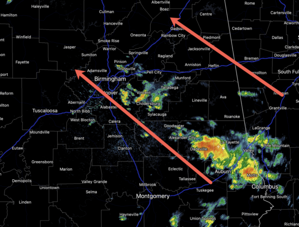
Rain and storms have returned to Alabama as an upper low to the west pulls moist air northward. Rain chances are in the 50-60% range; highs are in the low to mid 80s. Some rain could linger into the evening hours and affect a few of those Friday night football games.
FRIDAY NIGHT LIGHTS: For the high school games across Alabama tonight, a few scattered showers are possible, but many stadiums will be dry. Temperatures will fall through the 70s.
LABOR DAY WEEKEND: Tomorrow will feature a partly sunny sky, and we will mention some risk of scattered showers and thunderstorms over the southern half of the state. Highs will be in the 80s. Then, generally dry weather is expected Sunday and Monday with a good supply of sunshine both days. Highs will be in the mid to upper 80s over the northern counties of the state, with low 90s to the south. A very nice and tolerable weather forecast for the final holiday of summer.
FOOTBALL FORECAST: Tomorrow Jacksonville State hosts East Tennessee State (1:00 CT kickoff)… expect a mostly cloudy sky with temperatures around 80 degrees through the game. Just a slight risk of a shower.
Auburn will host UMass tomorrow afternoon at Jordan-Hare Stadium (2:30p CT kickoff)… the sky will be mostly cloudy; there is a small risk of a shower during the game. Expect a kickoff temperature near 83 degrees, falling to near 80 by the final whistle.
And, tomorrow evening Alabama hosts Middle Tennessee State at Bryant-Denny Stadium (6:30p CT kickoff). Expect a clearing sky with temperatures falling from near 81 degrees at kickoff through the 70s during the game.
THE FIRST FULL WEEK OF SEPTEMBER: Most of next week looks mainly dry and hot, with highs in the low to mid 90s across much of Alabama. We are not done with the summer heat just yet across the Deep South.
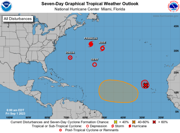
IN THE TROPICS: Idalia has become post-tropical and is approaching Bermuda. Hurricane Franklin is heading out in to the open North Atlantic. Tropical Storm Jose is a fish storm and is no threat to land. Gert is back from the dead and is a tropical depression again. Finally, Invest 94L off the African Coast, is now tropical depression twelve and will become Katia. Next, week, another tropical wave will emerge puff the African Coast, and will likely become Lee. None of these system are a threat to their U.S. anytime soon.
BEACH FORECAST CENTER: Get the latest weather and rip current forecasts for the beaches from Fort Morgan to Panama City on our Beach Forecast Center page. There, you can select the forecast of the region that you are interested in visiting.
WORLD TEMPERATURE EXTREMES: Over the last 24 hours, the highest observation outside the U.S. was 114.3F at In-Salah, Algeria. The lowest observation was -108.0F Vostok, Antarctica.
CONTIGUOUS TEMPERATURE EXTREMES: Over the last 24 hours, the highest observation was 117F at Death Valley and Stovepipe Wells, CA. The lowest observation was 28F at Bynum, MT.
Category: Alabama's Weather, ALL POSTS
About the Author (Author Profile)
Macon, Georgia Television Chief Meteorologist, Birmingham native, and long time Contributor on AlabamaWX. Stormchaser. I did not choose Weather, it chose Me. College Football Fanatic. @Ryan_StinnetSubscribe
If you enjoyed this article, subscribe to receive more just like it.


