Sunday Weather Video Briefing: Dry For Labor Day
Saturday was a very pleasant day across much of Alabama. With a high amount of moisture across the area, clouds were pretty prevalent in most spots. This held temperatures mainly back into the upper 70s and lower 80s. Afternoon highs ranged from 77F at Haleyville to 79F at Alex City to 81F at Birmingham to 84F at Tuscaloosa. Those readings were 5-12 degrees below normal for the first of September. There were a few light showers during the late afternoon, but they only resulted in a few sprinkles in isolated spots.
FOR YOUR SUNDAY: High pressure at the surface is centered near Asheville, North Carolina this morning. This high pressure is ridging down into Alabama. But the return flow underneath the high will permit a few light showers to form over Southwest and West Central Alabama during the morning hours, perhaps into the afternoon. Highs today will be a little warmer, generally getting into the middle and upper 80s with a little more in the
way of sunshine. Lows tonight will be in the upper 60s to lower 70s.
LABOR DAY LOOK: A couple of isolated showers could show up during the day across the same areas as today, mainly West central and Southwest Alabama. But most spots will remain bone dry, which is great for those outings to the lake, the park, or the golf course. Highs tomorrow will be in the around 90 degrees.
REST OF THE WEEK: Tuesday will be a not-so-bad late summer day in Central Alabama, as dry air and high pressure will be in place. No rain is expected and highs in the upper 80s to the lower 90s.
Heat levels will rise on Wednesday as we’ll remain dry with plenty of sunshine. Highs in the lower to mid 90s. The good news is that heat index values look to stay close to the actual temperature.
Thursday will be another day with plenty of sunshine, but there may be just enough moisture in the atmosphere for a very small chance of an isolated afternoon shower. Don’t expect too much in the way of precipitation as dewpoints will remain lower. Highs in the lower to mid 90s. And at the end of the forecast period on Friday… Weather conditions will be almost an exact duplicate of Thursday. Plenty of sun and hot with a very small chance of an isolated afternoon shower. Highs in the lower to mid 90s.
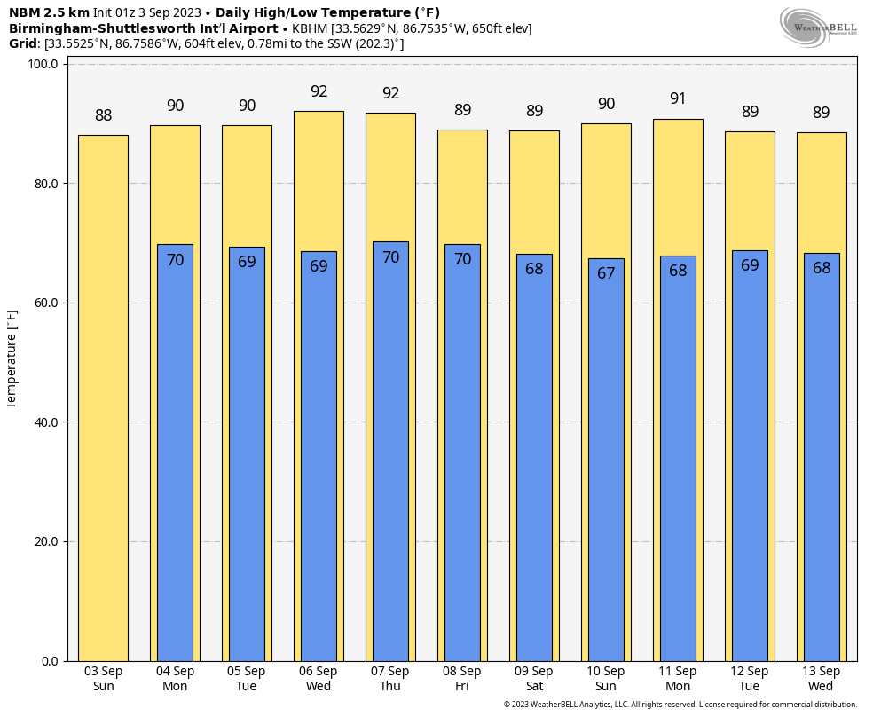
WEEKEND OUTLOOK: The same frontal system that will bring the return of shower chances by Friday will keep them in the forecast for Friday and Saturday. But they won’t be widespread or heavy. Weekend highs will be near 90F, with lows near 70F.
VOODOO TERRITORY: Our pattern will become more progressive during the week two period, bringing a couple of rounds of showers and storms around midweek and the weekend. Highs will be mainly in the 80s until the weekend, when 70s will take over. Lows will be in 60s except over the weekend, when there will be a few 50s.
BEACHCAST: It’s going to be a beautiful week along the gorgeous beaches of Alabama and Northwest Florida. Lots of sunshine and hot temperatures will make beach goers think it is still July. Highs will be warming through the 90s and lows will be in the middle and upper 70s. Water temperatures are in the middle 80s still. There will be a low to moderate rip current risk through much of the week ahead.
Click here to see the Beach Forecast Center page.
IN THE TROPICS: It has been a busy tracking chart across the Atlantic for the past ten days. Idalia is still with us this morning, in a post-tropical state. It passed close to Bermuda yesterday, bringing 56 mph wind gusts to the island. The storm is expected to recurve toward Atlantic Canada before midweek. Tropical Storm Katia is battling wind shear over the eastern Atlantic, but the wind shear will win out by Monday. This morning, Tropical Storm Gert is moving northward over the Central Atlantic. There is not a lot of model consistency on this one, but it is expected to be absorbed by Idalia early in the week. Invest 92L may be our next concern. The system is near longitude 27W, or south of the Cape Verde Island this morning and is showing good signs of organization on satellite. The models bring it to near the northern Lesser Antilles by Friday or Saturday, perhaps as a strong tropical storm, perhaps as something stronger. There is some thought that the low latitude might help the system take a more southerly track into the Caribbean. We will be watching. The next name on the list: Lee.
NATIONALLY: Las Vegas has seen three straight days of rain, including 0.88” on Friday, which caused flooding along the Strip and in various areas around the city.
ADVERTISE WITH US: Deliver your message to a highly engaged audience by advertising on the AlabamaWX.com website. We have a lot of big plans for this year. Don’t miss out! We can customize a creative, flexible, and affordable package that will suit your organization’s needs. Contact me, Bill Murray, at (205) 687-0782 and let’s talk.
WEATHERBRAINS: This week, the panel will entertain a group of forecasters from the SPC. Check out the show at www.WeatherBrains.com. You can also subscribe on iTunes. You can watch the show live on our new YouTube channel for the show.You will be able to see the show on the James Spann 24×7 weather channel on cable or directly over the air on the dot 2 feed.
ON THIS DATE IN 1925: The headline on the Thursday, September 3, 1925 edition of the self proclaimed “South’s Greatest Newspaper,” The Birmingham News, moaned the loss of the U.S. naval dirigible Shenandoah, which broke apart after flying into a line of thunderstorms over Ohio. It had been traveling westward from Lakehurst, NJ when it encountered the squall line. Four Alabamians were on the ship. Also on the front page was the heat in Birmingham. It had started to heat up in Birmingham late in August, when temperatures would normally be expected to begin dropping. But the heat really started in earnest in early September. On the 3rd, the high reached at Birmingham reached 101.5F at 1:15 p.m. in the afternoon at the Birmningham weather office in Fountain Heights. Weatherman E.C. Horton called for fair and warm weather to continue. There would be six more straight days of 100F+ degree heat followed by five more in late September. Add this to the three 100F+ temperatures in late August, and there were 15 100F+ days in 1925, the most ever in Birmingham weather history. Follow my weather history tweets on Twitter. I am @wxhistorian at Twitter.com.
Category: Alabama's Weather, ALL POSTS, Tropical
About the Author (Author Profile)
Bill Murray is the President of The Weather Factory. He is the site's official weather historian and a weekend forecaster. He also anchors the site's severe weather coverage. Bill Murray is the proud holder of National Weather Association Digital Seal #0001 @wxhistorianSubscribe
If you enjoyed this article, subscribe to receive more just like it.


