First snow day update (1220 am CST)
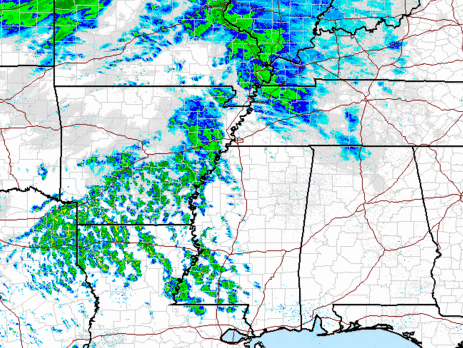
Due to the brief return of southerly flow to our west, some light precipitation has developed over AR, LA, and MS due to the warm air going up and over the colder air near the surface. Some of this precipitation is not reaching the ground, due to very dry air below 5,000 feet or so.
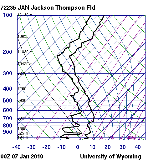
The forecast has gotten more complicated this evening, as balloon data from 00 UTC (6 pm) showed warm air just above the surface to our SW, and dry air here. Below is the balloon data from Jackson, MS (similar to BHM, but without a malfunction at low levels).
Notice the low dewpoints (the left curve) below 800 mb. The relative humidity at some levels is below 30%. So, some of the first precipitation to fall will not reach the ground, reducing potential snow accumulations a little. Some warm air is coming in aloft also, and the actual critical thickness line for snow is now up to Cullman. UAH MPR measurements (temperature profile every minute) show the warming aloft…about 9 degrees F at 1 km above the ground since noon.
However, the dry air and associated evaporative cooling should cool the air aloft enough to allow the rain/snow line to drop quickly south once precipitation starts to reach the ground. Precipitation could even change over to snow as far south as Selma and Montgomery before ending this evening.
With the dry air in place, the main precipitation may start a little later than we previously thought (we could see a few sleet pellets or snow flurries early this morning, but those are not the main event we’re talking about). It could start as early as 9 am in west Alabama, probably around noon in BHM, and afternoon in east Alabama. The highest precip amounts will be south, but the cold air will be north, and it looks like the sweet spot for the maximum snow due to combination of cold air and precipitation will be between BHM and Clanton. Probably about 1″ in BHM and maybe also in MGM, as much as 2″ near Clanton, with amounts 1″ or less in Cullman and Gadsden. Given the very cold ground and likelihood of travel problems once the snow starts, businesses in BHM that are open today should consider letting employees go home by noon, if possible.
The bitterly cold air is still a major concern. So far in 2010, 106 out of 145 hours have been below freezing at BHM. And, other than maybe 2 or 3 hours this morning before the precipitation, at least the next 78 hours, through Sunday morning, will likely be below freezing. Friday and Saturday will be extremely cold, with lows 10 to 15 and highs only in the 20s, with wind chills near zero. Please make sure to check on the elderly and make sure they have adequate, safe heat (space heaters are a fire hazard if used improperly, and kerosene heaters that are old or working improperly can cause carbon monoxide poisoning). If someone you know does not have safe heat, invite them over for a couple of days if possible. Also, please bring the pets in if at all possible, even if you have to put them in a bathroom or something, they won’t mind too much. At this point, many pipes have already frozen, but if you haven’t had any to freeze yet and have any that are vulnerable, do something about them immediately. Also, protect your home from cold air leaking in around poorly-fitting doors and windows using towels or blankets.
Things can still change, but my best guess before shutting it down for some sleep tonight! James will have a video update in a few hours.
Category: Uncategorized


