Midday Nowcast: Storms Later Today; Lee Near Hurricane Strength
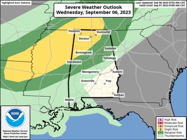
The SPC has defined a “slight risk” (level 2/5) of severe thunderstorms for areas north of a line from Reform to Hanceville to Scottsboro. A “marginal risk” (level 1/5) extends down to Demopolis, Jemison, and Heflin. A boundary will arrive later this afternoon, and will initiate storm development over portions of Alabama. Timing will be from 4PM-10PM. The main threat will strong straight line winds. It won’t rain everywhere, as rain chances are only in the 40-50% range. Storms will weaken and fade late tonight as they drop southward through the state. Where it is not raining, it is hot, with highs in the low 90s. Any showers tomorrow will be confined to far South Alabama and areas near the Gulf Coast. Tomorrow will be partly too mostly sunny with highs in the upper 80s for most locations.
FRIDAY AND THE WEEKEND: Great weather highlights the forecast for the end of the week and into the weekend. The weather will be very pleasant with mostly sunny days, lower humidity, and cooler nights. Highs will be in the mid to upper 80s, with lows well down in the 60s. Cooler spots across North Alabama could reach the 50s.
FOOTBALL WEATHER: The sky will be clear for the high school football games across Alabama Friday night with temperatures falling through the 70s.
Saturday, UAB will take on Georgia Southern in Statesboro, GA (5:00p CT kickoff)… the sky will be occasionally cloudy, and a passing shower or thunderstorm can’t be ruled out during the game. Temperatures will fall from near 89 degrees at kickoff through the 80s during the second half.
Alabama will host Texas Saturday evening at Bryant-Denny Stadium (6:00p CT kickoff)… the sky will be clear with temperatures falling from near 83 degrees at kickoff, into the 70s by the second half.
Auburn will be in Berkeley to take on the California Golden Bears (9:30p CT kickoff)… expect a clear sky with temperatures in the 60s during the game.
NEXT WEEK: Dry air will likely remain in place for much of next week with little risk of showers. Highs will hold in the 85-90 degree range most afternoons with lows in the 60s. Pretty routine mid-September weather for Alabama.
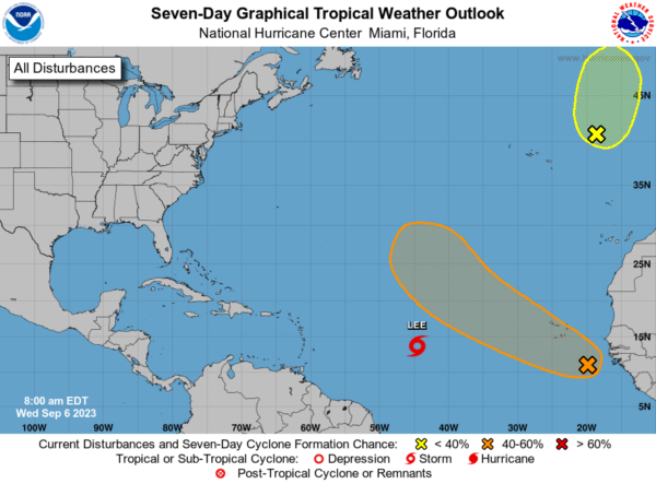
TROPICS: Lee is strengthening and will become a hurricane later today. Lee is moving toward the west-northwest near 14 mph and this motion is expected to continue for the next few days with a slight reduction in forward speed.
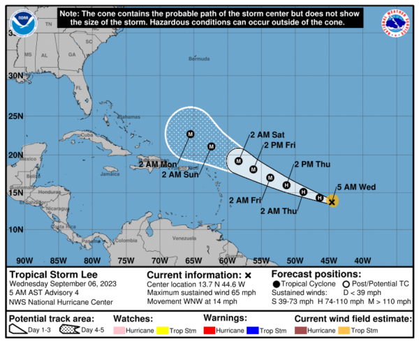
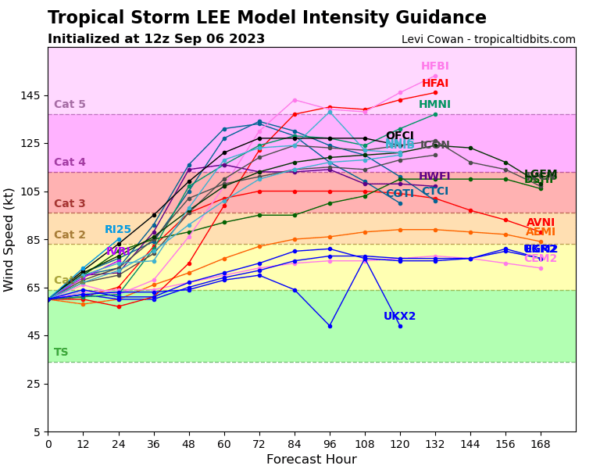
Maximum sustained winds have increased to near 70 mph with higher gusts. Continued steady to rapid strengthening is forecast, and Lee is expected to become a hurricane later today and a major hurricane in a couple of days.
Tropical-storm-force winds extend outward up to 80 miles from the center. The estimated minimum central pressure is 994 mb (29.36 inches). We of course will keep an eye on it, but the global models turn the system to the north, east of the East Coast and west of Bermuda.
Another wave coming off the African Coast will could develop as well, but it should remain in the open waters of the Atlantic. This system could become Margot.
BEACH FORECAST CENTER: Get the latest weather and rip current forecasts for the beaches from Fort Morgan to Panama City on our Beach Forecast Center page. There, you can select the forecast of the region that you are interested in visiting.
WORLD TEMPERATURE EXTREMES: Over the last 24 hours, the highest observation outside the U.S. was 120.6F at Omidieh, Iran. The lowest observation was -112.4F Vostok, Antarctica.
CONTIGUOUS TEMPERATURE EXTREMES: Over the last 24 hours, the highest observation was 115F at Rio Grande Village, TX. The lowest observation was 28F at Mackay, ID.
Category: Alabama's Weather, ALL POSTS
About the Author (Author Profile)
Macon, Georgia Television Chief Meteorologist, Birmingham native, and long time Contributor on AlabamaWX. Stormchaser. I did not choose Weather, it chose Me. College Football Fanatic. @Ryan_StinnetSubscribe
If you enjoyed this article, subscribe to receive more just like it.


