

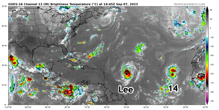
TD14 Forms; Lee On Way to Being a Major Hurricane
BULLETIN
Tropical Depression Fourteen Advisory Number 1
NWS National Hurricane Center Miami FL AL142023
200 PM CVT Thu Sep 07 2023
…DEPRESSION FORMS OVER THE EASTERN TROPICAL ATLANTIC…
SUMMARY OF 200 PM CVT…1500 UTC…INFORMATION
———————————————-
LOCATION…15.7N 26.4W
ABOUT 160 MI…260 KM W OF THE CABO VERDE ISLANDS
MAXIMUM SUSTAINED WINDS…35 MPH…55 KM/H
PRESENT MOVEMENT…WNW OR 295 DEGREES AT 17 MPH…28 KM/H
MINIMUM CENTRAL PRESSURE…1005 MB…29.68 INCHES
WATCHES AND WARNINGS
——————–
There are no coastal watches or warnings in effect.
DISCUSSION AND OUTLOOK
———————-
At 200 PM CVT (1500 UTC), the center of Tropical Depression Fourteen
was located near latitude 15.7 North, longitude 26.4 West. The
depression is moving toward the west-northwest near 17 mph (28
km/h), and this motion is expected to continue during the next
several days.
Maximum sustained winds are near 35 mph (55 km/h) with higher gusts.
Gradual strengthening is expected during the next several days, and
the depression is forecast become a tropical storm later today or
tonight.
The estimated minimum central pressure is 1005 mb (29.68 inches).
HAZARDS AFFECTING LAND
———————-
None
NEXT ADVISORY
————-
Next complete advisory at 800 PM CVT.
Forecaster Kelly/Camposano
Here is a beautiful satellite image of the two systems this morning and their forecast tracks and wind radii.
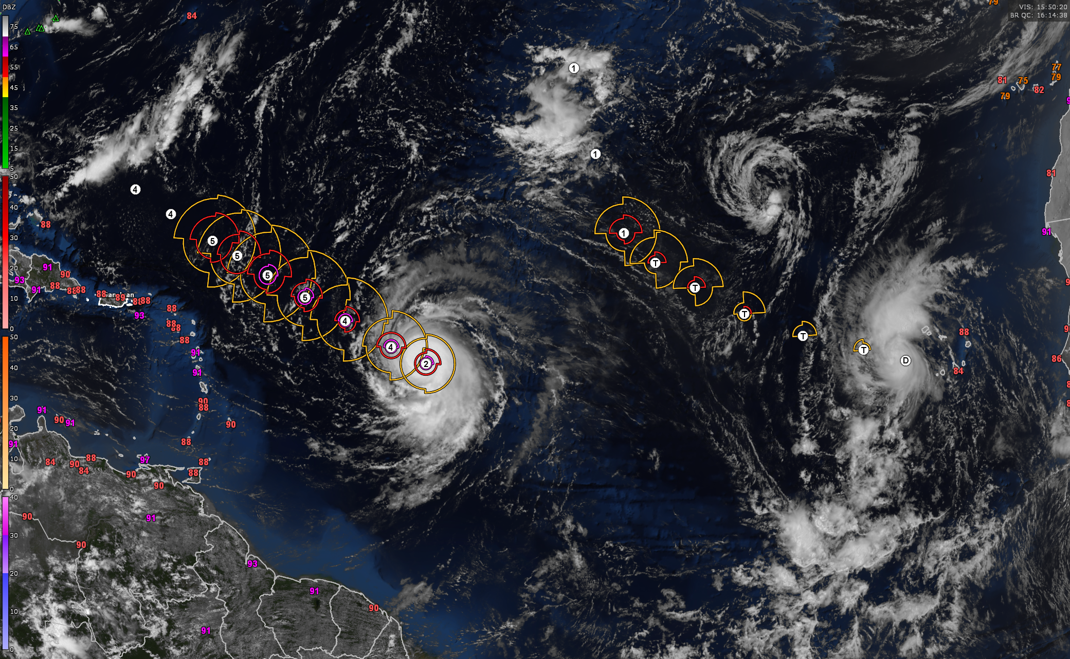
HURRICANE LEE
Hurricane Lee has entered a phase of rapid strengthening, displaying a well-defined eye visible in both infrared and visible satellite imagery. It is highly probable that Lee will further intensify to a Category 4 hurricane by tonight, and potentially reach Category 5 strength by Friday night or Saturday. Maintaining at least Category 4 strength, Lee is expected to persist into the first half of the upcoming week.
Lee’s track for the week appears to be relatively stable, with a west-northwest trajectory on a beeline that should keep the hurricane positioned well north of the northern Leeward Islands, the Virgin Islands, and Puerto Rico, thereby reducing the immediate threat to the northeastern Caribbean. Nonetheless, these regions may experience the outer rain bands of Lee over the weekend, along with hazardous marine conditions like high surf and rip currents from Friday through early next week.
Lee’s forecast becomes increasingly complex and uncertain next week. There is a possibility that Lee could slow down or stall in forward speed during the early part of the week, followed by a potential northward turn towards the middle of the week. The hurricane’s eventual location will be crucial in determining its impact, with scenarios ranging from a threat to areas along the US East Coast, particularly New England, to a track into the open Atlantic. While some model ensembles suggest a direct landfall in New England and a majority indicate a landfall in Atlantic Canada, it is essential to emphasize that forecasts beyond 7 to 9 days remain highly speculative. Therefore, exact location predictions and the positioning of pressure systems should not be heavily relied upon at this time.
At present, the greatest risk areas appear to be New England, especially eastern New England, and the entirety of Atlantic Canada. Bermuda also faces a potentially significant threat from Lee, with a potential impact around the middle of next week, followed by the period of late next week and next weekend (September 15-17) for regions spanning from parts of New England through Atlantic Canada. Nevertheless, it remains essential to exercise caution and monitor updates as the situation develops further.
BULLETIN
Hurricane Lee Advisory Number 9
NWS National Hurricane Center Miami FL AL132023
1100 AM AST Thu Sep 07 2023
…LEE RAPIDLY STRENGTHENING…
…LARGE SWELLS LIKELY TO REACH THE LESSER ANTILLES, THE VIRGIN
ISLANDS, AND PUERTO RICO THIS WEEKEND…
SUMMARY OF 1100 AM AST…1500 UTC…INFORMATION
———————————————–
LOCATION…16.4N 50.0W
ABOUT 870 MI…1405 KM E OF THE NORTHERN LEEWARD ISLANDS
MAXIMUM SUSTAINED WINDS…105 MPH…165 KM/H
PRESENT MOVEMENT…WNW OR 295 DEGREES AT 15 MPH…24 KM/H
MINIMUM CENTRAL PRESSURE…983 MB…29.03 INCHES
WATCHES AND WARNINGS
——————–
There are no coastal watches or warnings in effect.
Interests in the northern Leeward Islands should monitor the
progress of Lee.
DISCUSSION AND OUTLOOK
———————-
At 1100 AM AST (1500 UTC), the center of Hurricane Lee was located
near latitude 16.4 North, longitude 50.0 West. Lee is moving toward
the west-northwest near 15 mph (24 km/h), and this motion is
expected to continue through Friday. A slower motion toward the
west-northwest is forecast over the weekend. On the forecast track,
the core of Lee will move north of the northern Leeward islands
during the next few days.
Maximum sustained have quickly increased to near 105 mph (165 km/h)
with higher gusts. Rapid intensification is expected today and
tonight. Lee will likely become a major hurricane later today. Lee
is forecast to remain a very strong major hurricane through the
weekend
Hurricane-force winds extend outward up to 25 miles (35 km) from the
center and tropical-storm-force winds extend outward up to 90 miles
(150 km).
HAZARDS AFFECTING LAND
———————-
Key messages for Lee can be found in the Tropical Cyclone Discussion
under AWIPS header MIATCDAT3 and WMO header WTNT43 KNHC and on the
web at hurricanes.gov/text/MIATCDAT3.shtml
SURF: Swells generated by Lee are expected to reach portions of
the Lesser Antilles on Friday, and reach the British and U.S.
Virgin Islands, Puerto Rico, Hispaniola, the Bahamas, and Bermuda
this weekend. These swells are likely to cause life-threatening
surf and rip current conditions. Please consult products from your
local weather office.
NEXT ADVISORY
————-
Next complete advisory at 500 PM AST.
Forecaster D. Zelinsky
**Hurricane Lee Intensifying and Tracking West-Northwestward:** Hurricane Lee has entered a phase of rapid strengthening, displaying a well-defined eye visible in both infrared and visible satellite imagery. It is highly probable that Lee will further intensify to a Category 4 hurricane by tonight, and potentially reach Category 5 strength by Friday night or Saturday. Maintaining at least Category 4 strength, Lee is expected to persist into the first half of the upcoming week.
**Track Projections for Lee and Regional Impact:** Lee’s track for the week appears to be relatively stable, with a west-northwest trajectory that should keep the hurricane positioned well north of the northern Leeward Islands, the Virgin Islands, and Puerto Rico, thereby reducing the immediate threat to the northeastern Caribbean. Nonetheless, these regions may experience the outer rain bands of Lee over the weekend, along with hazardous marine conditions like high surf and rip currents from Friday through early next week.
**Uncertain Future for Lee Beyond Next Week:** As we look ahead to next week, Lee’s forecast becomes increasingly complex and uncertain. There is a possibility that Lee could slow down or stall in forward speed during the early part of the week, followed by a potential northward turn towards the middle of the week. The hurricane’s eventual location will be crucial in determining its impact, with scenarios ranging from a threat to areas along the US East Coast, particularly New England, to a track into the open Atlantic. While some model ensembles suggest a direct landfall in New England and a majority indicate a landfall in Atlantic Canada, it is essential to emphasize that forecasts beyond 7 to 9 days remain highly speculative. Therefore, exact location predictions and the positioning of pressure systems should not be heavily relied upon at this time.
**Primary Risk Areas and Timeline:** At present, the greatest risk areas appear to be New England, especially eastern New England, and the entirety of Atlantic Canada. Bermuda also faces a potentially significant threat from Lee, with a potential impact around the middle of next week, followed by the period of late next week and next weekend (September 15-17) for regions spanning from parts of New England through Atlantic Canada. Nevertheless, it remains essential to exercise caution and monitor updates as the situation develops further.
About the Author (Author Profile)
Bill Murray is the President of The Weather Factory. He is the site's official weather historian and a weekend forecaster. He also anchors the site's severe weather coverage. Bill Murray is the proud holder of National Weather Association Digital Seal #0001 @wxhistorianSubscribe
If you enjoyed this article, subscribe to receive more just like it.


