Hurricane Lee Officially Category Five
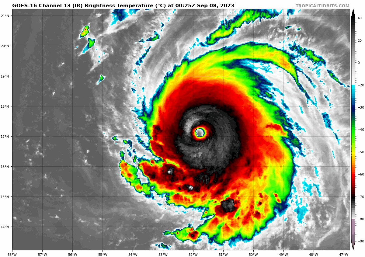
Hurricane Lee is becoming a very powerful storm tonight. Flight level winds of 148 knots were measured by the Hurricane Hunters. SFMR measured 161 mph, so the intensity was upped to 160 mph.
The central pressure is 928 mb.
Read the NHC discussion below. Notice that NHC Forecaster Robbie Berg mentioned that the HAFS-A and HAFS-B model peaks the intensity between 170 and 180 knots, or 195 and 207 mph. Truly rarefied air, as he states. The official forecast peaks it at 175 mph tomorrow evening.
The strongest Atlantic hurricane on record in terms of 1 min sustained winds is Hurricane Allen from 1980, with 190 mph. In terms of central pressure, Wilma, at 882 mb.
Lee’s winds have increased 70 knots (80 mph) in 24 hours. Rapid intensification is defined as 35 mph in 24 hours.
Eight storms have strengthened 80 mph in 24 hours. The most recent were Eta and Iota in 2020.
Hurricane Lee Discussion Number 11
NWS National Hurricane Center Miami FL AL132023
1100 PM AST Thu Sep 07 2023
The Air Force Reserve Hurricane Hunters have found that Lee has
skyrocketed to category 5 strength. The aircraft measured peak
700-mb flight-level winds of 148 kt and trustworthy SFMR winds
slightly over 140 kt, and dropsonde data shows that the minimum
pressure has plummeted to 928 mb. Based on these data, the initial
intensity is set at 140 kt, and Lee’s maximum winds have increased
by an incredible 70 kt over the past 24 hours. The hurricane has a
clear 15 n mi-wide eye, with an infrared eye temperature as warm
as 21 C surrounded by convective cloud tops as cold as -76 C.
Additional strengthening appears likely, as Lee remains in a
low-shear environment and over very warm waters near 30 degrees
Celsius, and there are no signs of an imminent eyewall replacement.
In fact, based on guidance from UW-CIMSS, the probability of a
secondary eyewall formation during the next 24 hours is well below
climatology. There is some chance that moderate deep-layer
southwesterly shear could develop over the hurricane, but this
could be offset by strong upper-level divergence and thus have
little to no impact. To account for the recent rate of
intensification, the NHC intensity forecast is slightly above the
IVCN and HCCA consensus aids and shows a peak intensity of 155 kt in
12 hours. Amazingly, the 1800 UTC HAFS-A and -B runs show a peak
intensity between 170-180 kt, but that’s getting into rarefied air.
The NHC forecast will be adjusted accordingly if those solutions
begin looking like a more distinct possibility. Only very gradual
weakening is shown after 12-24 hours, and it is likely that Lee’s
intensity will fluctuate for much of the forecast period. Lee is
forecast to remain a dangerous category 4 or 5 hurricane for the
next 5 days.
For the next 5 days–through next Tuesday evening–Lee is expected
to maintain a steady west-northwestward track, passing well to the
north of the northern Leeward Islands, the Virgin Islands, and
Puerto Rico. The hurricane is currently moving at about 12 kt, but
it is expected to slow down considerably through early next week as
the steering ridge to its north builds southwestward, effectively
blocking Lee’s progress. The NHC track forecast remains of high
confidence through day 5, and again, no significant changes were
required from the previous forecast. Although there are some
indications that Lee might begin a northward turn around the middle
of next week, it is still way to soon to focus on specific model
scenarios that far out into the future.
KEY MESSAGES:
1. Lee has become a dangerous category 5 hurricane, and further
strengthening is forecast overnight. Lee’s core is expected to move
well north of the northern Leeward Islands, the Virgin Islands, and
Puerto Rico this weekend and early next week.
2. Dangerous surf and life-threatening rip currents are likely in
the northern Leeward Islands beginning Friday. These conditions
will spread westward and northward, affecting Puerto Rico,
Hispaniola, the Turks and Caicos, the Bahamas, and Bermuda through
the weekend.
3. It is way too soon to know what level of impacts, if any, Lee
might have along the U.S. East Coast, Atlantic Canada, or Bermuda
late next week, particularly since the hurricane is expected to
slow down considerably over the southwestern Atlantic. Regardless,
dangerous surf and rip currents are expected along most of the U.S.
East Coast beginning Sunday. Continue to monitor updates to Lee’s
forecast during the next several days.
FORECAST POSITIONS AND MAX WINDS
INIT 08/0300Z 17.3N 52.4W 140 KT 160 MPH
12H 08/1200Z 18.1N 54.0W 155 KT 180 MPH
24H 09/0000Z 19.1N 56.1W 150 KT 175 MPH
36H 09/1200Z 20.1N 58.0W 145 KT 165 MPH
48H 10/0000Z 20.9N 59.6W 140 KT 160 MPH
60H 10/1200Z 21.5N 60.9W 135 KT 155 MPH
72H 11/0000Z 22.1N 62.2W 130 KT 150 MPH
96H 12/0000Z 23.2N 64.7W 125 KT 145 MPH
120H 13/0000Z 24.1N 66.6W 115 KT 130 MPH
Forecaster Berg
BULLETIN
Hurricane Lee Advisory Number 11
NWS National Hurricane Center Miami FL AL132023
1100 PM AST Thu Sep 07 2023
…LEE BECOMES A CATEGORY 5 HURRICANE…
…DANGEROUS BEACH CONDITIONS EXPECTED TO DEVELOP AROUND THE
WESTERN ATLANTIC THROUGH EARLY NEXT WEEK…
SUMMARY OF 1100 PM AST…0300 UTC…INFORMATION
———————————————–
LOCATION…17.3N 52.4W
ABOUT 705 MI…1135 KM E OF THE NORTHERN LEEWARD ISLANDS
MAXIMUM SUSTAINED WINDS…160 MPH…260 KM/H
PRESENT MOVEMENT…WNW OR 295 DEGREES AT 14 MPH…22 KM/H
MINIMUM CENTRAL PRESSURE…928 MB…27.41 INCHES
WATCHES AND WARNINGS
——————–
There are no coastal watches or warnings in effect.
DISCUSSION AND OUTLOOK
———————-
At 1100 PM AST (0300 UTC), the center of Hurricane Lee was located
near latitude 17.3 North, longitude 52.4 West. Lee is moving toward
the west-northwest near 14 mph (22 km/h), and this motion is
expected to continue through early next week with a significant
decrease in forward speed. On the forecast track, Lee is expected
to pass well to the north of the northern Leeward Islands, the
Virgin Islands, and Puerto Rico over the weekend and into early
next week.
Data from an Air Force Reserve Hurricane Hunter aircraft indicate
that maximum sustained winds have increased to near 160 mph (260
km/h) with higher gusts. Lee is a category 5 hurricane on the
Saffir-Simpson Hurricane Wind Scale. Additional strengthening is
forecast overnight. Fluctuations in intensity are likely over the
next few days, but Lee is expected to remain a major hurricane
through early next week.
Hurricane-force winds extend outward up to 45 miles (75 km) from the
center and tropical-storm-force winds extend outward up to 140 miles
(220 km).
The minimum central pressure based on dropsonde data is 928 mb
(27.41 inches).
HAZARDS AFFECTING LAND
———————-
Key messages for Lee can be found in the Tropical Cyclone Discussion
under AWIPS header MIATCDAT3 and WMO header WTNT43 KNHC and on the
web at hurricanes.gov/text/MIATCDAT3.shtml
SURF: Swells generated by Lee are expected to reach portions of the
Lesser Antilles on Friday, and reach the British and U.S. Virgin
Islands, Puerto Rico, Hispaniola, the Turks and Caicos Islands, the
Bahamas, and Bermuda this weekend. These swells are likely to cause
life-threatening surf and rip current conditions. Dangerous surf and
rip currents are expected to begin along most of the U.S. East Coast
beginning Sunday. Please consult products from your local weather
office.
NEXT ADVISORY
————-
Next complete advisory at 500 AM AST.
Forecaster Berg
About the Author (Author Profile)
Bill Murray is the President of The Weather Factory. He is the site's official weather historian and a weekend forecaster. He also anchors the site's severe weather coverage. Bill Murray is the proud holder of National Weather Association Digital Seal #0001 @wxhistorianSubscribe
If you enjoyed this article, subscribe to receive more just like it.


