Saturday Weather Briefing – Rain & Some Thunder Likely for Much of the Area Today
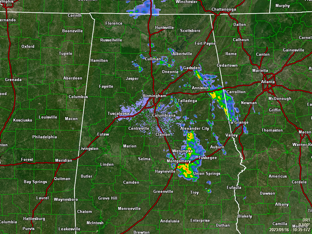
As of 5:37 this morning, we have some scattered shower activity mainly over the eastern half of Central Alabama with most of the activity located around the Alexander City, Wetumpka, and Montgomery areas. And the forecast for today looks to be about the same. The eastern half of the area will see scattered to numerous showers with just a little thunder, while the western half’s rain chances will be a little less. Highs ranging from the upper 70s to the upper 80s from northeast to southwest.
Sunday will be a much drier day as a cool front will have pushed through the area during the overnight hours. A few lingering showers may be left over across the eastern half during the morning hours, but much drier air will be moving in after frontal passage. Clouds will be on the decrease and highs in the 80s.
Monday will be an absolute wonderful day across the area as skies will be sunny and highs in the upper 70s to the upper 80s. High pressure over the east coast will send a northeasterly flow across Central Alabama on Tuesday, which will keep us clear with highs in the upper 70s to the upper 80s.
On Wednesday, ridging starts to develop over the south-central parts of the country and will weaken the flow across Central Alabama, which will bring a slight warm up. Sunny skies with highs in the 80s. The ridge gets forced back to the west on Thursday, and the northeasterly flow across the area strengthens. We’ll have sunny skies with highs in the upper 70s to the upper 80s.
And at the end of the forecast period on Friday… It will pretty much be the same as Thursday as we’ll have sunny skies and highs in the upper 70s to the mid 80s.
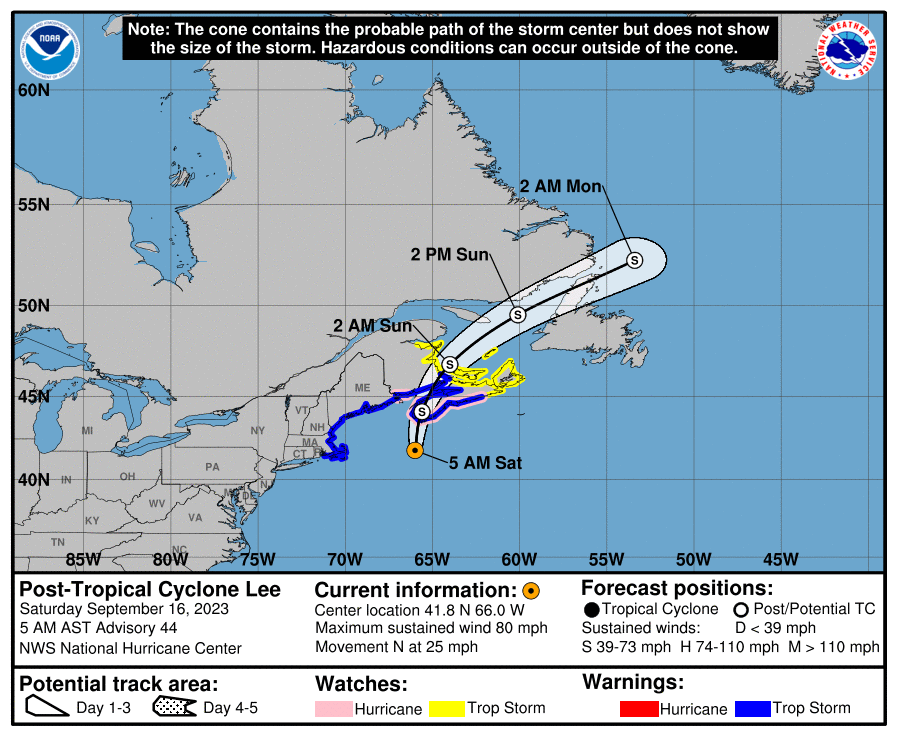
Lee has become post-tropical this morning, but is still producing maximum sustained winds at 80 mph as it continues to move north toward Nova Scotia and move across the extreme eastern parts of Atlantic Canada through the weekend. Lee will eventually be absorbed by another low pressure system after moving out over the Atlantic.
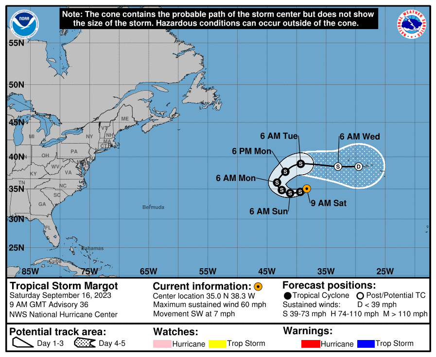
Tropical Storm Margot continues to meander around over the open waters of the Atlantic with maximum sustained winds at 60 mph. A major U-turn is expected as Margot will eventually be absorbed with the same system that gets Lee. While she is no threat to land for now, the current track has Margot moving over the Azores by midweek as a post-tropical depression.
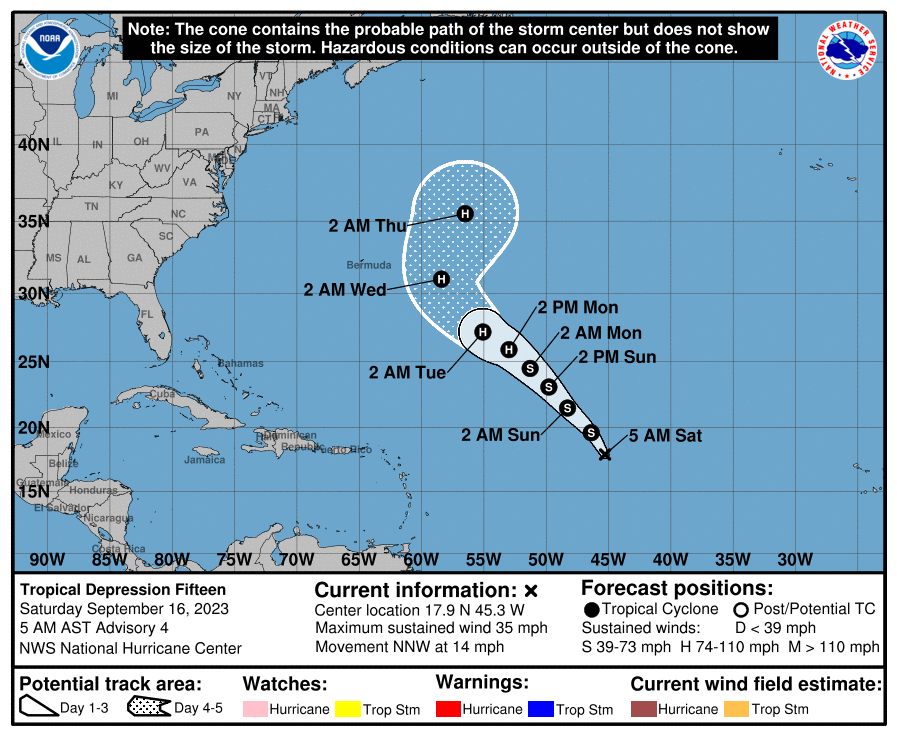
Tropical Depression 15 is located over the Central Tropical Atlantic and is moving to the northwest. Within a few hours, we will see the depression strengthen into Tropical Storm Nigel. Eventually, the system will become a hurricane while moving northwestward, but it will curve away from any landmass and pester the fish and shipping lanes.
Category: Alabama's Weather, ALL POSTS, Tropical, Weather Xtreme Videos
About the Author (Author Profile)
Scott Martin is an operational meteorologist, professional graphic artist, musician, husband, and father. Not only is Scott a member of the National Weather Association, but he is also the Central Alabama Chapter of the NWA president. Scott is also the co-founder of Racecast Weather, which provides forecasts for many racing series across the USA. He also supplies forecasts for the BassMaster Elite Series events including the BassMaster Classic.Subscribe
If you enjoyed this article, subscribe to receive more just like it.


