Midday Nowcast: Plenty of Sunshine
OH SO NICE!!!: The splendid weather continues across Alabama today and the rest of this week. Sunny days, refreshing nights, low humidity, and very tolerable afternoon highs. Highs most of this week will range from the low to upper 80s. Lows will be in the 50s the next several nights before inching back up in those 60s. We will mention the outside chance of a stray shower Thursday as an upper level features swings through the state, but even then, rain chances are less than 10%.
FOOTBALL WEATHER: The sky will be clear for the high school games across Alabama Friday night, with temperatures falling through the 70s, possibly reaching the 60s by the fourth quarter.
Saturday Auburn will travel to College Station to take on Texas A&M (11a CT kickoff)… the sky will be mostly sunny with temperatures rising from near 88 at kickoff to near 93 by the final whistle.
Alabama will host Ole Miss at Bryant-Denny Stadium Saturday (2:30p CT kickoff)… the sky will be mostly sunny with temperatures in the mid 80s.
And, UAB will be in Athens to take on Georgia Saturday evening (6:30p CT kickoff). The weather looks dry with a mostly clear sky… temperatures will fall from near 77 at kickoff, into the 60s by the fourth quarter.
HELLO FALL: With falls official arrival Saturday at 1:49 AM CDT, the pattern doesn’t change much and the weather looks dry with highs holding in the 80s, and lows in the 60s. Lots of sunshine both Saturday and Sunday. Next week starts off the same way, but by midweek, we could have to increase those rain chances as moisture levels begin to rise.
IN THE TROPICS: Hurricane Nigel is moving toward the northwest near 13 mph. The hurricane is forecast to turn northward late today, and then accelerate rapidly northeastward through the rest of the week. Maximum sustained winds have increased to near 90 mph with higher gusts. Nigel could strengthen some more through early Wednesday, but weakening is likely on Thursday and Friday. Nigel is forecast to become a strong post-tropical cyclone on Friday.
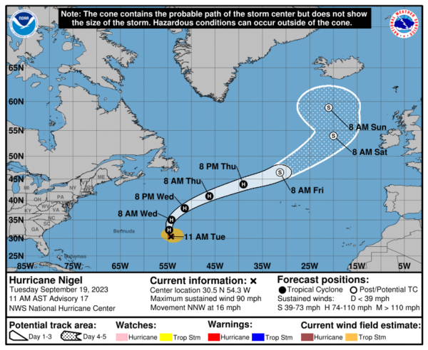
Hurricane-force winds extend outward up to 45 miles from the center and tropical-storm-force winds extend outward up to 175 miles. The estimated minimum central pressure is 975 mb (28.80 inches).
Elsewhere, a tropical wave is expected to move off the west coast of Africa by Wednesday. Environmental conditions are forecast to be conducive for gradual development of the wave thereafter, and a tropical depression is likely to form late this week or this weekend while the system moves generally westward across the eastern and central tropical Atlantic. Formation chance through 7 days…high…70 percent.
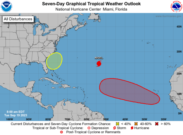
Also, a non-tropical area of low pressure is forecast to form east of the Florida peninsula late this week. This system could acquire some subtropical characteristics this weekend while it moves generally northward. Regardless of subtropical development, this low could bring gusty winds, heavy rain, and high surf conditions to portions of the coastal Carolinas into the coastal Mid-Atlantic states this weekend. Formation chance through 7 days…low…30 percent.
BEACH FORECAST CENTER: Get the latest weather and rip current forecasts for the beaches from Fort Morgan to Panama City on our Beach Forecast Center page. There, you can select the forecast of the region that you are interested in visiting.
WORLD TEMPERATURE EXTREMES: Over the last 24 hours, the highest observation outside the U.S. was 117.1F at Yenbo, Saudi Arabia. The lowest observation was -73.8F Amundsen-Scott South Pole Station, Antarctica.
CONTIGUOUS TEMPERATURE EXTREMES: Over the last 24 hours, the highest observation was 105F at Death Valley, CA. The lowest observation was 22F at Peter Sinks, UT.
Category: Alabama's Weather, ALL POSTS
About the Author (Author Profile)
Macon, Georgia Television Chief Meteorologist, Birmingham native, and long time Contributor on AlabamaWX. Stormchaser. I did not choose Weather, it chose Me. College Football Fanatic. @Ryan_StinnetSubscribe
If you enjoyed this article, subscribe to receive more just like it.


