Midday Nowcast: Sunny Friday; Soon to Be Ophelia
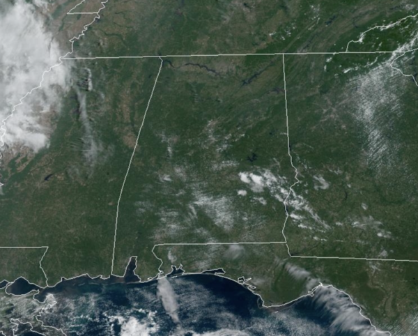
FINAL DAY OF SUMMER: Plenty of sunshine across Alabama today with temperatures near seasonal averages, ranging from the low to upper 80s across the state. Not at all a bad final day of summer 2023.
FRIDAY NIGHT LIGHTS: The sky will be clear for the high school games across Alabama tonight, with temperatures falling through the 70s, possibly reaching the 60s by the fourth quarter.
HELLO FALL: Fall arrives are 1:49 AM CDT, but the weather doesn’t change much of the weekend. More sunshine than clouds both days with highs in the mid to upper 80s. Saturday will be dry, most of Sunday will be as well, but we still need to mention the chance for a few stray showers late in the day, but again, rain chances are less than 20%.
COLLEGE FOOTBALL FORECAST: Tomorrow Auburn will travel to College Station to take on Texas A&M (11a CT kickoff)… the sky will be mostly sunny with temperatures rising from near 88 at kickoff to near 94 by the final whistle.
Alabama will host Ole Miss at Bryant-Denny Stadium tomorrow (2:30p CT kickoff)… the sky will be mostly sunny with temperatures in the mid 80s.
And, UAB will be in Athens to take on Georgia tomorrow evening (6:30p CT kickoff). The weather looks dry with a mostly clear sky… temperatures will fall from near 77 at kickoff, into the 60s by the fourth quarter.
NEXT WEEK: We will mention daily rain chances the first few days of next week, but nothing too heavy or widespread. But there will be a few showers on the radar each days. The days will feature more sunshine than clouds with highs in the low 80s. Nights will be fair with lows in the 60s. By the end of the week, drier air looks to return, removing our rain chances. Highs looks to slip down into the 70s by the following weekend.
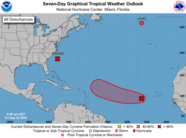
IN THE TROPICS: Nigel has become post-tropical. Potential Tropical Cyclone 16 will likely soon become Ophelia is moving toward the north near 12 mph. A north to north-northwest motion is expected during the next couple of days. On the forecast track, the center of the low will approach the coast of North Carolina tonight, and then move across eastern North Carolina, southeastern Virginia, and the Delmarva Peninsula Saturday and Sunday.
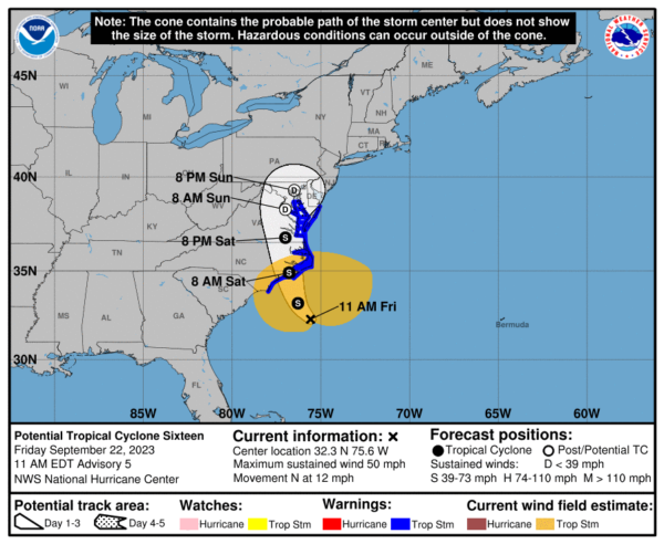
Maximum sustained winds are near 50 mph with higher gusts. Some strengthening is forecast before landfall, and the low is
expected to become a tropical storm before it reaches the coast of North Carolina. Regardless of whether it becomes a tropical storm, the system is expected to bring tropical storm conditions to portions of the southeast and mid-Atlantic coasts.
Tropical-storm-force winds extend outward up to 275 miles from the center. NOAA buoy 41025 at Diamond Shoals, North Carolina,
recently reported a sustained wind of 40 mph and a gust of 51 mph. The estimated minimum central pressure based on surface observations is 996 mb (29.42 inches).
Elsewhere, Shower and thunderstorm activity associated with an area of low pressure located about 600 miles west-southwest of the Cabo Verde Islands continues to show signs of organization. Further development is expected, and a tropical depression is likely to form during the next couple of days while the system moves generally westward at 10 to 15 mph. The system is then expected to turn west-northwestward early next week as it moves over the central tropical Atlantic. Formation chance through 7 days…high…90 percent.
Next names up Philippe and Rina.
BEACH FORECAST CENTER: Get the latest weather and rip current forecasts for the beaches from Fort Morgan to Panama City on our Beach Forecast Center page. There, you can select the forecast of the region that you are interested in visiting.
WORLD TEMPERATURE EXTREMES: Over the last 24 hours, the highest observation outside the U.S. was 114.3F at Basra International Airport, Iraq. The lowest observation was -84.3F Vostok, Antarctica.
CONTIGUOUS TEMPERATURE EXTREMES: Over the last 24 hours, the highest observation was 110F at Rio Grande Village, TX. The lowest observation was 18F at Kirk, OR.
Category: Alabama's Weather, ALL POSTS
About the Author (Author Profile)
Macon, Georgia Television Chief Meteorologist, Birmingham native, and long time Contributor on AlabamaWX. Stormchaser. I did not choose Weather, it chose Me. College Football Fanatic. @Ryan_StinnetSubscribe
If you enjoyed this article, subscribe to receive more just like it.


