Sunday Morning Weather Briefing: Moisture Levels to Increase
Fall started officially early Saturday morning. The autumnal equinox is the point when the center of the Sun passes equator going north to south. Days will be shorter than nights until the winter solstice, which on December 21st. Temperatures in the week ahead will be very near normal for the first week of fall, especially on Monday and beyond.
A WARM SATURDAY: Plenty of sunshine led to a warm afternoon across North and Central Alabama. High temperatures ranged from 88F in Anniston, Birmingham, and Calera to 92F in Tuscaloosa. With drier air that has been rotating into the state from the northeast in the wake of Ophelia, readings across the northeastern quarter of Alabama fell into the 50s overnight, while the rest of the area was in the lower 60s.
FOR YOUR SUNDAY: After this morning crisp and comfortable start, moisture levels will be rising through the day from the west. That will mean a gradual increase in cloudiness through the afternoon hours. Afternoon readings today will be in the lower and middle 80s Northeast, with readings in the upper 80s to near 90F in other areas. Lows tonight will range from 59F around Scottsboro and Fort Payne to the lower and middle 60s across South Central Alabama.
THE WORK WEEK AHEAD: Moisture levels will continue to increase from the west on Monday, and this will lead to some light rain mainly near and west of I-59 Monday afternoon and evening. Expect highs in the upper 80s. A few light showers will continue into Tuesday, and there could be an isolated storm., with highs in the middle and upper 80s. Wednesday will be similar with just an isolated shower or storm, but temperatures will be few degrees cooler. Slight rain chances will continue on Thursday as a back door frontal system tries to wedge in from the northeast. Then much drier will begin to spill in over the weekend, putting an end to rain chances as high-pressure ridges down from the Ohio Valley and New England. Temperatures will be near seasonal norms, in the lower 80s for highs and lower 60s for lows.
VOODOO COUNTRY: The week two forecast period will feature dry and mild weather, just about what you would expect as you transition into October in Alabama, with highs in the lower 80s and lows in the lower 60s.
BEACHCAST: Many folks say that September is the best time to go to the beach, and this weekend is proving that out with lots of sunshine, warm temperatures and no rain. But rain will creep back into the forecast by late Tuesday and it will be a feature into the end of the week. But sprawling high pressure will take over weather across the Gulf Coast and the Deep South by next weekend, giving a period of fine weather to the beautiful beaches of Alabama and Northwest Florida. Water temperatures are in the lower 80s. the rip current risk will be low.
Click here to see the Beach Forecast Center page.
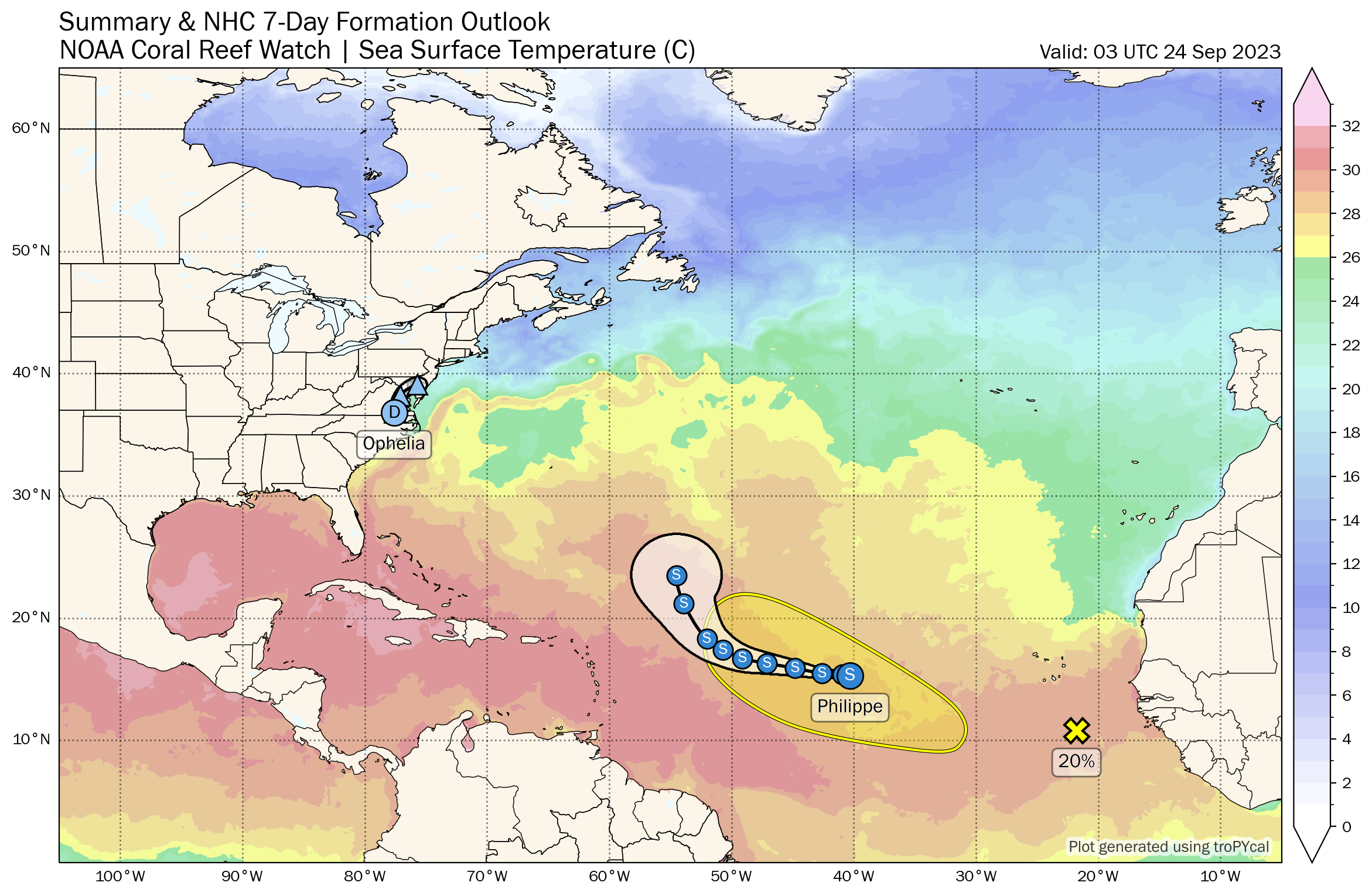
IN THE TROPICS: Ophelia made landfall early yesterday morning around 5:15 a.m. CDT, near Emerald Isle, NC as a 70-mph tropical storm. The system probably reached hurricane status briefly around 9 p.m. Friday night, but it will go into the record books as a tropical storm. The system weakened as it moved inland into North Carolina on Saturday. This morning, the center of the tropical depression is just south of Washington, D.C. Top winds are 35 mph. The depression is executing a sharp right turn this morning and will be back over the Atlantic after passing over southern New Jersey this evening. Tropical storm gusts have been felt from eastern North Carolina through eastern Virginia, the Delmarva, and into southern New Jersey. Some impressive rainfall totals were measured as well, with 9-10 inches estimated to have fallen across parts of Pitt County around Greenville where the Green Mill Run was at a record stage. Flash flooding was reported at several locations in eastern North Carolina with flash flood warnings from the coast to Rocky Mount. There were lots of flooding reports around Grenville. Storm surge reached 4-5 feet in the Pamlico River.
Tropical depression 17 was designated Saturday morning. It became a tropical storm Saturday afternoon and received the name Philippe. It is about 1185 miles east of the island of Guadeloupe this morning, with top winds of 40 mph. The storm will continue steaming westward with little intensity change for the next 2-3 days before beginning to gradually execute a turn to the north well east and northeast of the islands. By Thursday, it should be a 60 mph tropical storm some 800 miles northeast of San Juan. It may stall into the weekend before accelerating to the northeast into the graveyard of the North Atlantic.
The GFS is still hinting at close in development near the Mid-Atlantic coast, perhaps bringing another tropical storm to Virginia and the Delmarva. We will be watching.
NATIONALLY: An atmospheric river is bringing wind and rain to parts of northern California and southern Oregon today and tonight. Hopefully that is a sign of things to come for the West Coast with an active El Nino in place.
DANCING WITH THE STATS: 99F at Roswell NM Friday was a record for the date.
ADVERTISE WITH US: Deliver your message to a highly engaged audience by advertising on the AlabamaWX.com website. We have a lot of big plans for this year. Don’t miss out! We can customize a creative, flexible, and affordable package that will suit your organization’s needs. Contact me, Bill Murray, at (205) 687-0782 and let’s talk.
WEATHERBRAINS: This week, the Guest WeatherBrain will come from the panel as Dr. Neil Jacobs updates us on the latest developments in weather modeling. Check out the show at www.WeatherBrains.com. You can also subscribe on iTunes. You can watch the show live on our new YouTube channel for the show.You will be able to see the show on the James Spann 24×7 weather channel on cable or directly over the air on the dot 2 feed.
ON THIS DATE IN 1939: The “El Cordonazo” tropical storm raked Southern California as it made landfall between Los Angeles and San Diego. September rain records were set at Los Angeles with 5.66 inches and 11.6 inches at Mt. Wilson. Damages was $2 million and 45 people died, all at sea. Winds reached 50 mph. Follow my weather history tweets on Twitter. I am @wxhistorian at Twitter.com.
Category: Alabama's Weather, ALL POSTS, Tropical
About the Author (Author Profile)
Bill Murray is the President of The Weather Factory. He is the site's official weather historian and a weekend forecaster. He also anchors the site's severe weather coverage. Bill Murray is the proud holder of National Weather Association Digital Seal #0001 @wxhistorianSubscribe
If you enjoyed this article, subscribe to receive more just like it.


