Midday Nowcast: Rain on the Radar
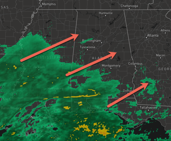
An are of low pressure loaded with tropical moisture is tracking through the Northern Gulf, bringing beneficial rain to portions of Alabama today and tonight. The most widespread and heaviest rain will be over the southern half of the state, where 1-2 inches are possible. The rain will continue to spread north into Central Alabama this afternoon, but rain amount will remain light for places like Birmingham, Tuscaloosa, and Anniston. Rainfall totals should not exceed 1/2 inch, while many locations in the Tennessee Valley are likely to stay dry. Temperatures this afternoon are in the 70s. The rain will end tonight as the surface lows moves to the east. For tomorrow, most of the state will be dry as the sky becomes partly sunny by afternoon. The high tomorrow afternoon will be in the low to mid 70s.
FRIDAY AND THE WEEKEND: An approaching cold front will bring a chance of showers statewide Friday and Friday night. Unfortunately it looks like rain amounts will be rather light and spotty with limited moisture available. Friday will be cloudy with highs in the 70s again. The sky will clear during the day Saturday, and Sunday will feature sunshine in fully supply. The high Saturday will be in the be in the low to mid 70s, then dropping into the 60s Sunday with a cool north breeze.
FOOTBALL WEATHER: For the high school games Friday night, the sky will be mostly cloudy with just a small risk of a shower. Temperatures will fall from near 70 at kickoff to the mid 60s by the final whistle.
Saturday, Alabama hosts Arkansas at Bryant-Denny Stadium (11a CT kickoff). The sky will be partly too mostly sunny with temperatures rising from near 72 at kickoff, into the mid 70s by the fourth quarter.
Auburn will be in Baton Rouge to take on LSU (6:00p CT kickoff). The sky will be clear with temperatures falling from near 76 at kickoff, into the upper 60s by the final whistle.
UAB is also on the road… they will take on UTSA in San Antonio (7:00p CT kickoff). The Roadrunners play their home games at the Alamodome, so weather won’t be an issue one way or another. But for the fans headed that way Saturday will be a sunny day in San Antonio with a high in the mid 80s. It will be clear Saturday night with temperatures falling through the 70s after sunset.
NEXT WEEK: For now most of the week looks dry with sunny pleasant days and clear cool nights; highs will be mostly in the 60s with lows in the 40s. With moderating temperatures into the 70s for the second half of the week. More fantastic fall weather for all of Alabama.
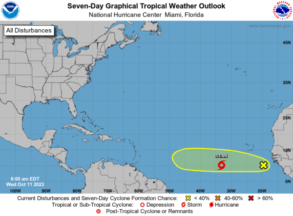
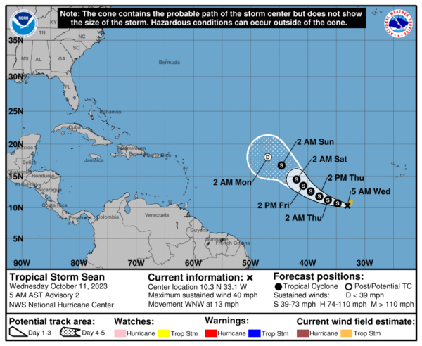
IN THE TROPICS: We have two features: In the far Eastern Tropical Atlantic, the National Hurricane Center is issuing advisories on recently upgraded Tropical Storm Sean. Sean is moving toward the west-northwest near 13 mph. A west-northwestward to northwestward motion is forecast during the next few days. Satellite intensity estimates indicate that the maximum sustained winds are near 40 mph with higher gusts. Little net change in strength is forecast during the next 72 hours. Tropical-storm-force winds extend outward up to 90 miles from the center. The estimated minimum central pressure is 1006 mb (29.71 inches).
Behind Sean, a tropical wave located several hundred miles to the south-southeast of the Cabo Verde Islands is producing a large area of showers and thunderstorms. This activity is showing some signs of organization this morning, and environmental conditions appear conducive for some additional development of this system over the next several days while the wave moves westward across the eastern and central tropical Atlantic. Formation chance through 7 days…low…30 percent.
The remaining names on list this year are Tammy, Vince, and Whitney.
BEACH FORECAST CENTER: Get the latest weather and rip current forecasts for the beaches from Fort Morgan to Panama City on our Beach Forecast Center page. There, you can select the forecast of the region that you are interested in visiting.
WORLD TEMPERATURE EXTREMES: Over the last 24 hours, the highest observation outside the U.S. was 110.8F at Mina, Saudi Arabia. The lowest observation was -85.2F Vostok, Antarctica.
CONTIGUOUS TEMPERATURE EXTREMES: Over the last 24 hours, the highest observation was 102F at Seeley, CA. The lowest observation was 19F at Davis, WV.
Category: Alabama's Weather, ALL POSTS
About the Author (Author Profile)
Macon, Georgia Television Chief Meteorologist, Birmingham native, and long time Contributor on AlabamaWX. Stormchaser. I did not choose Weather, it chose Me. College Football Fanatic. @Ryan_StinnetSubscribe
If you enjoyed this article, subscribe to receive more just like it.


