Midday Nowcast: Sunny, Cool, Breezy Monday
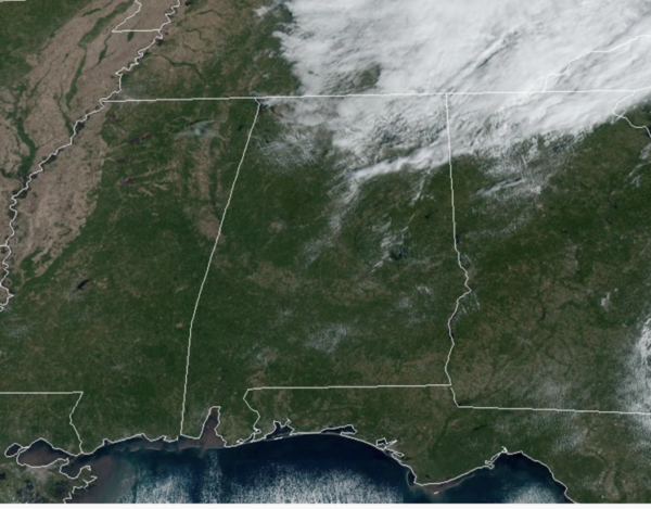
We are seeing a mostly sunny sky across Alabama with afternoon temperatures in the low to mid 60s. There remains a northwest wind of 10-20 mph, which is making it feel even cooler. Tonight will be clear and chilly with lows in the 40s; some of the colder spots across North Alabama will reach the upper 30s.
TOMORROW/WEDNESDAY: Look for sunshine in full supply tomorrow and Wednesday with a slow warming trend; highs will be in the upper 60s tomorrow, followed by low to mid 70s statewide by Wednesday afternoon. Nights will remain chilly with widespread 40s.
LATE WEEK FRONT: Thursday will be dry, but clouds will be increasing, and we will bring in a chance of rain statewide Thursday night and Friday ahead of a surface cold front. Moisture will be limited, and rain amounts will be light; generally under a quarter of an inch. The high Thursday will be in the low 70s. Highs fall back into the mid and upper 60s Friday under a mostly cloudy sky.
ANOTHER FANTASTIC FALL WEEKEND: Another surge of dry air rolls into the state Friday night, and the weekend will feature sunny pleasant days and clear cool nights. Highs will range from the upper 60s to lower 70s; lows mostly in the 40s.
NEXT WEEK: A ridge will build across the Deep South, meaning dry weather is likely through the week with highs mostly in the 70s, and lows in the 40s and 50s.
IN THE TROPICS: A broad area of low pressure located over the central tropical Atlantic about midway between the Windward Islands and western Africa is producing disorganized shower activity. The low-level circulation has become better defined since yesterday and, since environmental conditions are expected to remain conducive for further development, a tropical depression is still likely to form within a few days. This system is forecast to move westward or west-northwestward across the central and western tropical Atlantic during the next several days. Formation chance through 7 days…high…70 percent.
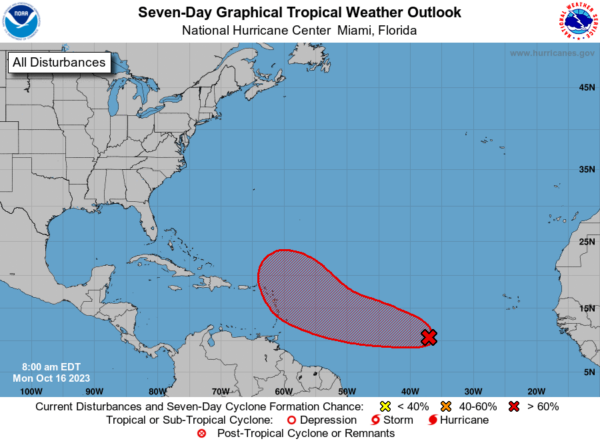
The remaining names on list this year are Tammy, Vince, and Whitney.
BEACH FORECAST CENTER: Get the latest weather and rip current forecasts for the beaches from Fort Morgan to Panama City on our Beach Forecast Center page. There, you can select the forecast of the region that you are interested in visiting.
WORLD TEMPERATURE EXTREMES: Over the last 24 hours, the highest observation outside the U.S. was 122.0F at Siteki, Eswatini. The lowest observation was -88.6F Concordia, Antarctica.
CONTIGUOUS TEMPERATURE EXTREMES: Over the last 24 hours, the highest observation was 103F at Tempe, AZ. The lowest observation was 14F at Angel Fire, NM.
Category: Alabama's Weather, ALL POSTS
About the Author (Author Profile)
Macon, Georgia Television Chief Meteorologist, Birmingham native, and long time Contributor on AlabamaWX. Stormchaser. I did not choose Weather, it chose Me. College Football Fanatic. @Ryan_StinnetSubscribe
If you enjoyed this article, subscribe to receive more just like it.


